Desert Architecture for a New Millenium
![]() No. 47, May 2000
No. 47, May 2000
Desert Architecture for a New Millenium
by Arch. David Pearlmutter
"The spatial requirements of a post-industrial society, whose most valuable commodity is information, may differ quite radically from those which we now take for granted....If the traditional patterns of desert settlement - with geographically self-contained, compact cities attuned to the carrying capacity of the land - seem to be a hopeless historical relic, it might be that technology has in fact given them, and the desert itself, new relevance." |
Part 1: The question of compactnessUrban "compactness" in the desertThe attractiveness of a place is a matter of perception, and the desert has historically faced an image problem. The very word "desert" conjures up images of an inhospitable wilderness - hot, dry and dusty. It is not surprising, then, to find the traditional urban settlement in arid regions built with its back to its surroundings, shutting out the harshness of the open desert and attempting to implant some urban version of an oasis in its midst. In cities of the Middle East and other arid regions, this enclosure commonly evolved as a dense, tightly-knit pattern of contiguous buildings with narrow streets and small courtyards intertwined within the urban fabric. The notion that such vernacular building responses by early desert urbanists were climatically motivated is expressed in the literature on desert architecture: "Urban experience in the arid zones shows that compact forms are effectively adjusted to climatic stress. The necessity of human adaptation to arid zones brought about the development of these compact urban forms, which have microclimates more moderate than those of the environs. The narrow, winding alleys and streets, which block sunlight, are relatively cool and block stormy winds..." (Golany 1980). In the 20th century, this oasis effect has been achieved with an entirely different approach, and the image of the desert city has in some cases been reversed. Development of the "Sun Belt" cities in the American Southwest accelerated in no small measure due to the promise of sunny weather and clean dry air, which attracted migrants in search of a modern urban oasis. How has this transformation occurred? Perhaps it is the ability to transport water great distances, which has in effect converted arid land into local non-deserts with expansive lawns and generous landscaping. Or could it be that a bubble of air-conditioned space, whether for living, working or traveling, is never far away - de-emphasizing the stresses of the outdoor environment and all but trivializing the need for "narrow winding alleys and streets..."? Taken as a whole, these factors could be seen as a directive for "modern" city planning in the desert which is free environmental limitations. It is only when we begin to question the long-term sustainability of the accepted patterns - in which resources such as inexpensive fuel or clean air and water are treated as though they were of unlimited supply - that the inevitable costs of this approach become apparent. Much recent discussion of the "sustainable city" has in fact been accompanied by calls for more "compact" urban planning, based on the observation that commuter suburbs have led to a physical separation of activities within the city and extended resource lines in a particularly unsustainable manner. In most cities, suburban sprawl has had consequences ranging from increased air pollution and traffic accidents, to social inequity and the loss of urban vitality - and nowhere is the tendency toward sprawl greater than in the desert, where a relative abundance of undeveloped land often obscures the notion of limits. |
|
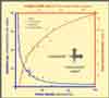
The "compactness" of a city may be expressed in different ways. Population density is a common measure, and one which has been directly correlated with environmental trends that could distinctly be called unsustainable. Cities of the American west have densities some 5-10 times lower, and gasoline consumption nearly 5 times higher, than their typical counterparts in Europe (Herzog, 1980). But a compactly built urban fabric may also be identified by its three-dimensional structure, as represented by the relation between the height of its buildings and the width of streets separating them. This height/width ratio of "urban canyons" has been correlated to what is probably the most intensively observed phenomenon in urban climatology: the so-called urban "heat island," or presence of air temperatures which are higher in and above cities than in the surrounding countryside. While the development of heat islands is known to have a number of probable causes, a compact urban geometry is without doubt a significant contributor. Can a case, then, really be made for compact planning in a hot desert environment? Warmer air would suggest higher air-conditioning loads and less-pleasant outdoor spaces. Other questions complicate the matter further: in desert areas with cold but sunny winters, how can a tightly-packed urban fabric accommodate solar access to individual buildings? And to what extent are desert dwellers interested in higher-density living, which would seem to come at the expense of their quality of life? Patterns of sustainability(Back to top) The obstacles to a more sustainable built environment cut across the typical boundaries - both in terms of scale, ranging from global considerations to local circumstance, and of content, involving economic and political concerns as well as technological. The designer of a passive solar building, for instance, will find his efforts futile if planners have failed to ensure solar access in an urban setting. Going further, the investment in energy-efficient design is not encouraged by clients - whether private developers or public planning officials - as long as the economics of energy consumption do not seem to justify them. And completing the circle, policy-makers are loath to offer incentives for saving energy if the average citizen doesn't demand it. It is this interconnectedness that thwarts many a plan for sustainable development before it can produce any noticeable impact. In a recent paper (Pearlmutter and Meir, 1999), an approach to this dilemma was suggested which is neither a specific plan, nor a general set of principles, but rather a common language which allows local sustainable solutions to be developed within a global context. By allowing the built environment to be considered in a way that is both interdisciplinary and scale interdependent, such a language offers the potential for addressing problems of development in a way that is as far-reaching as the sustainability paradigm itself. Such a language is composed of distinct strategies called "patterns," each of which describes a development process which has been shown to create or contribute to unsustainable trends, and identifies the essential ingredients required for a more sustainable solution. Patterns can exist at all scales and may deal with almost any kind of environmental forces. Within the language, each pattern both fulfills and is reinforced by other patterns, whether larger, smaller, or of similar scale. Rather than being adopted and enforced from above in the form of master plans, ordinances and codes, a language is intended to develop "from below" as well, and one of the most important ways of accomplishing this is through individual projects which set precedents. The present discussion will not focus on pattern languages per se, but rather, by way of illustration, will present a series of case studies from the Negev desert in Israel in which "patterns of sustainability are expressed. While these examples are intentionally drawn from different fields - including research, urban planning, and building design - it is precisely their integration which is intended to shed light on possible paths to more sustainable desert architecture. Urban microclimate in the desert(Back to top) As described by Gradus and Stern (1985), the result of this conceptual transplanting was a mismatch between the intentions of planners and the physical reality of the desert. Internal deserts within the city were created in the vacant areas designated for landscaping, due both to a lack of water and to a lack of interest, on the part of the largely immigrant population, in maintaining ornamental greenery. Inhabitants suffered from extensive walking distances in oppressive heat, and any sense of a cohesive urban fabric was overwhelmed by the feeling of dispersion and disconnectedness. The perception of exacerbated climatic harshness, along with other social and physical factors, led many planners to conclude that the Garden City model and its consequences for the urban structure were inappropriate to the arid Negev. In response to this perception, attempts were made to create denser, more compact residential environments, with one of the goals being the improvement of microclimatic conditions. "Patio house" neighborhoods with a compact structure of walled courtyards and narrow pedestrian paths were built as examples of the "new" approach, though in fact they echoed the traditional urban patterns typically found in the Middle East (and in the old city of Beer-Sheva itself, built during the period of Ottoman rule). While the desirability and attractiveness of such densely built neighborhoods have varied according to social and economic circumstance, the assumption that they are responsible for enhancing the microclimate in desert cities was never confirmed. As mentioned earlier, current knowledge in the field of urban climatology would suggest that compact planning could in fact prove detrimental in a hot climate due the urban heat island effect, and particularly its manifestation at the pedestrian level. Among the reasons for this relative overheating are the trapping of solar radiation (by decreases in both reflection of sunlight and re-emission of heat to the sky), and the substantial impairment of ventilation, that occur within the constricted spaces of urban canyons. While the urban heat island is most pronounced on clear nights, the processes which cause overheating within such street canyons have been found to be prominent during the daytime as well (Oke 1988). |
|
On the other hand, the internal shading of pedestrians and surrounding built surfaces that may occur in deep urban canyons provides relief from physiological heat stress, and this is not necessarily accounted for by measurements of air temperature. Shelter from undesirable winds, whether hot or cold, is also an important factor. As an attempt to make sense of these apparently divergent factors, an in-depth microclimatic analysis (Pearlmutter, 1998) was conducted within one of the previously mentioned patio house neighborhoods, built in the city of Dimona (elevation 600 m, or 1,970 ft) in the arid Negev Highlands. As is typical for many arid zones, the climate of the region is characterized by wide daily and seasonal thermal fluctuations. In summer, daily temperatures range from under 20°C (68°F) to over 32°C (90°F), and are accompanied by low daytime relative humidity, intense solar radiation and strong late afternoon winds, predominantly from the northwest. In winter, while minimum daily temperatures occasionally reach freezing and winds are strong, clear skies and abundant solar radiation prevail in the daytime (Bitan and Rubin, 1991). |
|
The neighborhood is composed of single-story row houses and attached walled courtyards, with a grid of narrow (3 m, or 10 ft) pedestrian streets dividing the rows. Microclimatic conditions during summer and winter seasons were monitored within two perpendicular streets, whose axes are approximately east-west and north-south, respectively, and were compared with those in the relatively open space above the flat roofs of the row house buildings. For a more inclusive picture of the thermal environment, as experienced by a pedestrian in the street, climatic measurements were integrated in a conceptual model (Pearlmutter et al. 1999) of the energy which is absorbed and released by the human body under given conditions. By encompassing both radiative and convective thermal exchanges, the model allows the effects of solar exposure, surface and air temperature, and wind to be evaluated in terms of a single rate of energy exchange between a pedestrian and the urban environment. Heat loss by evaporation is accounted for by converting these values into an Index of Thermal Stress (Givoni, 1963), which quantifies the rate at which the body must sweat in order to balance the environmental heat load. Since this index has been correlated with subjective "thermal sensation" responses in a number of empirical studies, it is possible to estimate the level of thermal comfort which is afforded by a given urban configuration. |
|
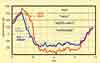
The study's results would seem to reinforce what is suggested by urban climate theory: relatively warm air is indeed found within the street canyons during the peak hours of a summer day, and wind speed is systematically reduced in the constricted spaces. However, a closer inspection reveals that temperature differences between locations are relatively minor and that the attenuation of wind depends very much on street orientation. When the prevailing wind direction is at a sharp angle to the street axis, a compact geometry will most certainly reduce the air flow, but if directed along the street's length, wind is less severely attenuated and may be stronger in a deep canyon than in a shallower one. |
|
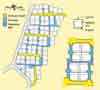
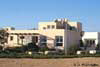
More telling is the pattern of overall thermal stress revealed by the above-mentioned index: despite any observed increase in air temperature or reduction in wind speed, on a summer afternoon a pedestrian inevitably absorbed less thermal energy in the compact street canyon than when standing in the open. This is most pronounced in north-south oriented streets and is naturally a function, above all, of internal shading from the intense desert sun. This factor, though, is joined by others: a narrow street also restricts exposure to diffuse radiation from the sky, and to long-wave radiation emitted from paved surfaces - which are heated by the sun to temperatures far higher than any vertical wall. Easing the thermal burden on a pedestrian means limiting the number of daytime hours during which discomfort is felt. But this relationship has just as much to do with night hours, when the body is losing energy - because though it is doing so more rapidly in the open than it is in the street, night-time heat stress is essentially non-existent anywhere in the urban fabric. It is here that we see the unique climatic advantage of a desert like the Negev, which experiences such rapid nocturnal cooling: whether at the level of a building or of an outdoor space, the planner has an opportunity to ameliorate the periods of most intense discomfort, by taking advantage of natural forces which prevail in the interim. What emerges from this case study, then, is evidence that a compact urban fabric in the desert can in fact contribute to a relative "cool island," in sharp contrast to what is so often emphasized in non-arid cities. Like the urban heat island in general, the micro-scale heating effect shown here is primarily a nocturnal phenomenon, and has far less relevance than it would in more tropical regions. (It is interesting to note that in winter, when the heat island effect is desirable, the compact street canyon was seen to reduce heat loss from the body during nearly all hours - primarily due to protection from cold winds.) It can therefore be suggested, at least for the Negev and similar desert regions, that the general environmental argument for a pattern of more compact cities is reinforced by microclimatic benefits as well. What, though, of the restrictions this may cause - on solar access in winter to the individual building, and on amenities like private open space and vehicular access? To address these questions, we will turn to a less theoretical example of urban design in the desert. Part 2: Toward sustainable desert architectureUrban design in the desert(Back to top) What makes Neve-Zin physically unique is the overall approach to urban design embodied in its development plan, which was designed and written by the Institute's Desert Architecture and Urban Planning Unit (Etzion, 1989). The neighborhood consists of 80 private building lots, with individual houses designed to fit residents' preferences but at the same time conforming to the detailed guidelines spelled out in the plan's building ordinances. |
|
Also detailed in the plan is the nature of the public realm, with an emphasis on creating a pedestrian-friendly atmosphere within the neighborhood fabric. This is first accomplished through the use of relatively narrow brick-paved streets, interlaced with landscape elements of different kinds. More important, though, is the way in which this circulation network is divided into two separate components - each with its own functional, and at the same time climatic, purpose. |
|
The first of these is a series of "main" streets which provide vehicular access into the neighborhood and are generally oriented along an east-west axis. While maintaining a pedestrian character, they are wide enough to accommodate limited two-way traffic. This width also serves one of the central objectives of the plan: to provide sufficient distance between buildings in the north-south direction, so that southern facades will enjoy unobstructed access to low-angle solar radiation in winter. |
|
A secondary network is composed of strictly pedestrian walkways, most of which are aligned north-south. Only 2.5 meters (8 ft) wide, they are shaded during summer morning and afternoon hours by flanking walls, providing the type of benefit for pedestrian comfort described earlier. The shading effect is increased by overhead trellises supporting deciduous vines. In general, water-intensive public landscaping is kept to a minimum, for both financial and ecological reasons. Individual building lots (averaging 600 m2 [6,460 ft2] in area) are typically clustered in groups of four, with each lot containing a "P-point" at its outer corner on which the actual house must stand. This mechanism encourages a pattern by which public paths are tightly defined by the protecting walls of adjacent buildings, while open space at the center of each cluster allows for ample ventilation as well as for private gardening - one of the expressed preferences of the original group of residents. |
|
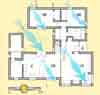
The overall effect of these different strategies is to modulate the urban fabric in a way that responds to seasonally changing solar geometry, encouraging a shaded pedestrian realm in summer and solar access to buildings in winter. Perhaps the most innovative feature of the neighborhood plan, however, is a mechanism which ensures the rights of each dweller to such solar access, by legally limiting the height of neighboring structures in relation to the winter sun. An imaginary "bulk plane" sloping upward at a prescribed angle from each lot's southern building line defines the volumetric limits of the building or any other obstruction to the south, guaranteeing that the house will be free of overshadowing throughout a winter day. This "solar rights" provision is one of many in the neighborhood plan which in fact give direction to the architectural design without in any way dictating the final form. In this way a natural variety is allowed to evolve, but within the context of a common design language which encourages a visually cohesive neighborhood fabric. By specifying, for example, essential features of building morphology and finish materials, this approach addresses the dilemma between monotony and chaos which afflicts so much of the built environment and which is a central motivation in the use of architectural pattern languages (Alexander, 1979). Architectural design in the desert(Back to top) This mutual interdependence may be illustrated by the following example of a single-family residence in Neve-Zin (one with which the author is especially familiar, in the dual capacity of designer and occupant). A central motif in the design of the house was, in fact, the extension of climatically-responsive patterns from the scale of the neighborhood to that of the private dwelling. |
|
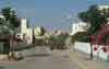
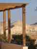
The house is sited, in accordance with its P-point, toward the southeast corner of its lot - and in this way it closely fronts the adjacent brick paved street to the east and is distanced from the open center of the cluster to the northwest. With its entrance directly from the street, the house presents a somewhat urban facade, and casts deep shadows onto the street during late summer afternoon hours. It is precisely this period which is a popular time for outdoor activity, but only in areas which are protected from the intense sun. Private open space to the west is treated to a similar effect, but with different means - using shade trees to filter sunlight and strong breezes, and to create a more private version of man-made oasis. Largely deciduous and drought-resistant (and including a number of fruit-bearing varieties), these trees are the dominant landscape element, providing definition and protection for a small grassy area whose "intensive" treatment contrasts sharply with the "extensive" ground cover of local crushed stone interspersed with succulent flowering desert plants. |
|
An even smaller-scale oasis is created by an internal patio, around which the entire house is spatially organized. While one purpose of this "outdoor room" is to provide an intimate semi-enclosed space where shade and breezes can be enjoyed in relative privacy, another is to facilitate passive climatic strategies in different parts of the house. By spacing the southern wing of the house, which contains the main living areas, apart from the northern two-story bedroom wing, both enjoy access to the winter sun along with cross-ventilation for cooling on summer nights. |
|
Such flexibility requires attention to detail: in this case the patio is covered with an array of seasonally selective panels which transmit the bulk of solar radiation in winter, but in summer both screen out the sun and allow rising warm air to escape. Operable doors in the northwest corner allow for controlled ventilation in summer, and protection from cold winds in winter - transforming the patio into a thermal buffer for the rooms surrounding it. (An additional buffer is found on the north side, where storage areas are stacked against the northern wall in a cascaded form which fits under the lines of solar access to the neighboring lot.) A somewhat different adaptation is required on the south side of the house, where a raised porch overlooks the dramatic desert cliffs of the Zin Canyon. Here, an overhead pergola is fitted with slatted shading panels, which in winter are simply removed to allow full sun to both the sitting area - also protected by the mass of the house from chill winds - and the sliding glass doors of the adjacent dining area. As is the general rule, these glazed openings are protected by insulated operable shutters which not only give shade from direct (and, when necessary, indirect) summer sun, but also reduce heat loss on cold winter nights. The basic envelope construction combines external rigid insulation with internal thermal mass (in the form of concrete floor and roof slabs and block walls) - which together minimize unwanted heat flow and stabilize the desert's sharp temperature swings. |
|
The cumulative effect of these design strategies may be judged, first, in terms of energy. For the majority of the year, including the hottest months of summer, thermally comfortable conditions can be achieved with entirely "passive operation" - which is to say the routine opening and closing of windows and shutters to insure daytime shading and night-time ventilation. In the winter season, solar energy provides over 90% of the heating which is required for "standard" buildings of similar size, with passive strategies alone responsible for a comfortable interior during all but the coldest periods of consecutively cloudy days. |
|
The data, though, in no way convey the intangible qualities of living in the desert in a conscious way, with an ongoing awareness of what the natural world has in store - whether it be dust storms, freezing rain, blissful sun or soothing breezes - and which is so often forgotten when we retreat to the safety of our "bubbles of air-conditioned space." Conclusions(Back to top) While the amenities of suburban life are indeed alluring, we find that many of them can be achieved without losing sight of the ecological price tag - simply by adopting a sane attitude toward basic ingredients like energy, water or soil. A high-quality living environment, providing comfort and even a degree of spaciousness, does not necessarily contradict the need for compactness, which, as illustrated by the case of Neve-Zin, is not just about high-density - but rather about modulating the built fabric to accommodate a number of criteria, of which a central one is microclimatic comfort. What does this example tell us, though, about the compact city in the larger context of sustainability? It should be remembered that "commuter suburbs" are in the end a functional phenomenon, defined by the separation of activities - particularly of the home from the workplace. What makes the community to which Neve-Zin belongs unique, perhaps above all else, is that it defies conventional definitions. Though it is small and isolated, it is not a rural community based on agriculture - but at the same time it is not a suburb, since the majority of its population both live and work within the settlement and therefore the average daily "commute" can be measured in steps rather than freeway exits. Perhaps, we suspect, this example is a quirk - a relic of some village life from the past. We need only open our eyes to see that the automobile is everywhere and cities simply follow its path, and therefore a pedestrian-centered approach tells us nothing about the present. But if we then take a step back, we wonder what it might say about the future. Urban geography has been molded by an industrial economy, which demands that the city be constantly accessible, physically, to the masses. Where, in this scheme of things, do we account for something like "telecommuting?" The spatial requirements of a post-industrial society, whose most valuable commodity is information, may differ quite radically from those which we now take for granted. It is doubtful that planners, let alone market forces, could have predicted even a decade ago the current trajectory of the Internet, whose ramifications - from electronic commerce to cottage industry - allow efficient communication to lessen the burden of wasteful transportation. If the traditional patterns of desert settlement - with geographically self-contained, compact cities attuned to the carrying capacity of the land - seem to be a hopeless historical relic, it might be that technology has in fact given them, and the desert itself, new relevance. If this is the case, how are planners and architects equipped to respond? Good intentions are clearly inadequate, as are isolated solutions detached from any larger context. For this reason we seek to evolve patterns of sustainable planning and building, which encapsulate accumulated wisdom for inhabiting the desert. The preceding discussion has considered the "compact city" as a potentially powerful pattern, because it is reinforced on different levels - and has offered some glimpses into more specific patterns which are needed to give it substance, relating to such issues as mixed land use, urban microclimate, open-space geometry, and bioclimatic design. To the extent that they are integrated into actual practice and stand the test of time, such patterns and others may build upon one another, gradually paving the way toward a shared language of desert architecture. References(Back to top) Bitan, A., and S. Rubin. 1991. Climatic atlas of Israel for physical planning and design. Tel Aviv: Israel Meteorological Service and Ministry of Energy and Infrastructure. Chandler, T.J. 1976. Urban climatology and its relevance to urban design. World Meteorological Organization Technical Note No. 149. Geneva: WMO. Etzion, Y. 1989. A desert solar neighborhood in Sede-Boker, Israel. Architectural Science Review 33:103-109. Givoni, B. 1963. Estimation of the effect of climate on man: Development of a new thermal index. Haifa, Israel: Technion - Israel Institute of Technology. Golany, G. 1980. Planning urban sites in arid zones: the basic considerations. In Urban planning for arid zones, ed. G. Golany. New York: John Wiley & Sons. Gradus, Y., and E. Stern. 1985. From preconceived to responsive planning: Cases of settlement design in arid environments. In Desert development: Man and technology in sparselands, ed. Y. Gradus. D. Dordrecht, Netherlands: Reidel Publishing Co. Herzog, T. 1996. Solar energy in architecture and urban planning. Munich and New York: Prestel-Verlag, p.33. Oke, T.R. 1988. Street design and urban canopy layer climate. Energy and Buildings 11:103-113. Pearlmutter, D. 1998. Street canyon geometry and microclimate: Designing for urban comfort under arid conditions. In Environmentally Friendly Cities, Proceedings of PLEA '98, Lisbon, Portugal, June 1998, eds. E. Maldonado and S. Yannas, 163-166. (Awarded "Best Paper" of PLEA '98 Conference). Pearlmutter, D., A. Bitan, and P. Berliner. 1999. Microclimatic analysis of "compact" urban canyons in an arid zone. Atmospheric Environment 33:4143-4150. Pearlmutter, D., and I.A. Meir. 1999. Building a language for sustainable community development in arid regions. In Sustaining the Future: Proceedings of PLEA'99, Brisbane Australia, September 1999, 783-788. |
![]()
(Back to top)
Architect David Pearlmutter is a researcher at The Desert Architecture and Urban Planning Unit, J. Blaustein Institute for Desert Research, Ben-Gurion University of the Negev, Israel. You can reach him for comment as follows:
Arch. David Pearlmutter
The Center for Desert Architecture and Urban Planning
The Jacob Blaustein Institute for Desert Research
Ben Gurion University of the Negev
Sede-Boqer Campus
Midreshet Ben-Gurion 84990
ISRAEL
Email: davidp@bgumail.bgu.ac.il
Web site: http://www.bgu.ac.il/CDAUP
(Back to top)
Heat Island Group
http://eetd.lbl.gov/heatisland/
The Heat Island Group at the Lawrence Berkeley National Laboratory (U.S.), works to find solutions to summer warming trends occurring in urban areas. Their current focus is the study and development of more reflective surfaces for roadways and buildings.
About the Arid Lands Newsletter