Using geospatial technologies to understand dryland dynamics
![]() No.
51, May/June 2002
No.
51, May/June 2002
Using geospatial technologies to understand dryland
dynamics
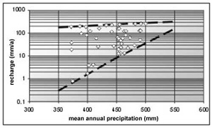
| Plot of calculated groundwater recharge rates with chloride mass balance method vs. mean annual precipitation for wells in Damara lithologies (karstified hard rock). Recharge rates are locally as high as 100 mm/a. |
 |
| Plot of calculated groundwater recharge rates with chloride mass balance method versus mean annual precipitation for wells in areas of Kalahari covered by sandy soils. Recharge rates are generally below 10 mm/a. | 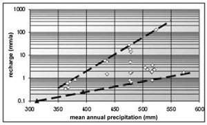 |