Special issue: Selected papers from the IALC Conference:
Assessing Capabilities of Soil and Water Resources in Drylands:
The Role of Information Retrieval and Dissemination Technologies

Special issue: Selected papers from the IALC Conference: Assessing Capabilities of Soil and Water Resources in Drylands: The Role of Information Retrieval and Dissemination Technologies |
|
by Daniel G. Neary, Leonard F. DeBano, and Malchus M. Baker, Jr. (deceased)
| "...the web-based delivery method facilitates better access to management information and technology, ultimately contributing to the increased sustainability of arid and semi-arid watersheds around the globe" |
Background(Back to top) Need for more water Looking into the future, it was quickly recognized that the amount of water available from underground aquifers was finite and that only a limited amount of additional water could be imported from other sources (e.g. the Lower Colorado River via the proposed Central Arizona Project). Likewise, little new water could be obtained by desalinization because only a limited amount of leached irrigation water was returned to the Lower Colorado River and desalinization technology in the 1960s had not advanced sufficiently to satisfy the ever-increasing demand for water. Although watershed managers had an intuitive understanding that the human population of the Southwest was going to increase, they would eventually be shocked by the fact that this region is the fastest- growing in the USA. It was quickly recognized by watershed managers prior to the 1960s, that the density of various forest and shrubland vegetation had increased since the middle of the 19th century, and as a result, streamflow in many of the perennial streams was diminishing. It was suggested that if a reduction in this increased vegetation density could somehow be implemented, then more water would be produced as streamflow from the upland watersheds. This concept led to the initiation of a comprehensive Arizona Watershed Program in Arizona during the late 1950s (Fox et al. 2000). The overall objective of this program was to explore vegetation management techniques that could be used to increase streamflow. Part of this project involved installing numerous experimental watersheds to evaluate the effects of vegetation manipulation on streamflow in mixed conifer and ponderosa pine forests, pinyon-juniper woodlands, and chaparral shrublands (Baker 1999). |
|
|
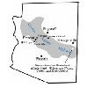
For the Arizona Watershed Program, the experimental watersheds formed a research network which was a collaborative program of public agencies and private groups interested in obtaining more water for future economic growth while maintaining the state's watersheds in good condition. Research watersheds were established at several locations in forests and woodlands of the central and eastern part of Arizona called the Central Arizona Highlands (Baker 1999). Experimental watersheds were established in five different vegetation types. The chaparral, pinyon-juniper, ponderosa pine, mixed conifer, and high elevation grassland ecosystems are situated along altitude-moisture gradients (Figures 1 and 2). Interior Chaparral: This vegetation type is restricted almost entirely to the Lower Colorado River Basin, where it covers about 1.4 million ha (Hibbert 1979). Chaparral species tend to be low-growing shrubs with thick, evergreen leaves well adapted to heat and drought. The type is common on rugged terrain from 1,050 to 2,150 m in elevation (Pase 1982, Brown 1982). Shrub live oak (Q. turbinella) is most abundant, followed by mountain mahogany. Other common shrubs are manzanita (Arctostaphylos spp.), Emory oak (Q. emoryi), silktassel (Garrya wrightii), desert ceanothus (Ceanothus greggii), and sugar sumac (Rhus ovata). Most species sprout prolifically from root crowns after burning or cutting and are difficult to eradicate. Average annual precipitation varies from about 380 mm at the lower limits to 635 mm at the higher elevations (Hibbert 1979). Approximately 60% of the annual precipitation occurs as rain or snow between November and April. Annual potential evaporation rates can approach 900 mm. Water yield varies greatly depending on precipitation, elevation, and soils. The overall average is 25 mm or more; the lower, drier sites produce little, while the wettest sites can yield 75 or 100 mm. Grasslands: Grassland vegetation in the Southwest includes the mountain grassland type, Great Plains grasslands (eastern New Mexico), and desert grasslands. The Arizona Watershed Program studies involved mountain grasslands and the Walnut Gulch program concentrated on the desert grass and shrub ecosystems. Changes in management practices in grasslands over the past century (alterations by grazing, both domestic and wildlife; exclusion of fire; and others) have resulted in an invasion of shrub and other woody plant species from adjacent vegetation zones on many sites. Thus, shrubs and other woody plant species form an intermixed overstory on many areas classified as grasslands at one time (Ffolliott and Thorud 1974). Occurring throughout a range of elevations, individual grassland types that comprise this zone exhibit differences in terms of water yield and other natural resource potentials. Mountain grasslands, small in aggregate area, are scattered throughout the mixed conifer and ponderosa pine forest types (Judd 1962; Lowe 1964). While tree species are not usually part of these communities, isolated trees or shrubs occur through invasion from the adjacent forests on cinder cones and elevated places within the grasslands. Characteristic grasses are timothy (Phleum pratense), Arizona fescue (Festuca arizonica), mountain muhly (Muhlenbergia montana), pine dropseed (Blepharoneuron triholepis), black dropseed (Sporobolus interreptus), mountain brome (Bromus marginatus), and the introduced Kentucky bluegrass (Poa pratensis). Many of these species have high forage value for livestock and wildlife species. Recreation is a valuable resource of these high elevation grasslands because they are intermixed with the relatively cool and esthetic mixed conifer and ponderosa pine forest types. Semi-desert grasslands in the Southwest are found at elevations ranging from 1,200 to 1,400 m (Brown 1982). Annual precipitation averages 250 to 450 mm with over 50% occurring during the April to September period, particularly when monsoon rains enter the Southwest. Pinyon-Juniper: These woodlands are below the ponderosa pine forests, at elevations between 1,500 and 2,300 m (Brown 1982). Colorado pinyon (Pinus edulis) is found throughout, with singleleaf pinyon (Pinus monophylla) occurring on limited areas. North of the Mogollon Rim, Utah juniper (Juniperus osteosperma), Rocky Mountain juniper (J. scopulorum), and one-seed juniper (J. monosperma) are intermixed with pinyon pine, while alligator juniper and Utah juniper are south of the Mogollon Rim. Annual and perennial grasses and grass-like plants, forbs, and half-shrubs and shrubs abound beneath the woodland overstories. Annual precipitation varies from 180 to 560 mm (Pase 1982; Brown 1982). Winter precipitation is usually rain with occasional snow. Evapotranspiration rates are relatively high in the growing season. Only during the coldest months of December through February is precipitation greater than the evapotranspiration rates. |
|
|
Montane Conifer: This forest type consists of the mixed conifer zone found at elevations between 2,438 and 3,048 m, and the ponderosa pine zone at the 1,676 to 2,591 m elevations on areas such as the Mogollon Plateau in Arizona (Pase 1982; Brown 1982). Seven coniferous and one deciduous tree species in a variety of mixtures characterize these high elevation forests. These species include Engelmann spruce (Picea engelmannii), blue spruce (P. pungens), Douglas-fir (Pseudotsuga menziesii var. glauca), white fir (Abies concolor), corkbark fir (A. lasiocarpa var. arizonica), ponderosa pine (Pinus ponderosa), southwestern white pine (P. strobiformis), and quaking aspen (Populus tremuloides). Annual precipitation in high elevation mixed conifer forests (above 2,895 m) ranges from 762 to 1,143 mm and is usually in excess of potential evapotranspiration. As a result, streams originating in this area are often perennial. Streams originating in low elevation mixed conifer forests (2,438 to 2,896 m) are mostly intermittent. Snowmelt runoff is a significant source of annual runoff. The relatively high precipitation amounts in the mixed conifer forest type results in a relatively lush vegetative environment in contrast to the vegetation types found at the lower elevation levels. This fact also contributes to its low potential for erosion and subsequent sedimentation. Ponderosa Pine: Ponderosa pine is the most widely distributed pine in North America, extending from British Columbia, Canada, in the north, to Durango, Mexico, in the south. In the United States, it is found from Nebraska west to the Pacific Coast. Ponderosa pine is found at elevations from sea level to about 2,743 m. Throughout its range, as you move from north to south, the species tends to grow at progressively higher elevations, and it is more restricted to higher elevations in drier climates. Most of the ponderosa pine forests in the Southwest are at elevations between 1,676 and 2,591 m on the Mogollon Plateau in Arizona. Although ponderosa pines dominate these forests, they often contain Douglas-fir, quaking aspen, and southwestern white pine at high elevations, and alligator juniper (Juniper depeanna) and Colorado pinyon (Pinus edulis) and its singleleaf form (P. edulis var. fallax) at low elevations. Gambel oak (Quercus gambelii) is scattered throughout. Grasses and grasslike plants, forbs, and half-shrubs grow beneath ponderosa pine overstories. Ponderosa pine is generally found in regions with arid conditions and summer rainfall. For typical areas where ponderosa pine grows in the United States, average annual precipitation varies from 254 to 533 mm, and the average precipitation during the growing season (May through August) is from 51 to 152 mm. Where ponderosa pine grows in Arizona, 85 % of the total growing seasonal precipitation of 178 mm falls in July and August following the May-June dry period. Summer showers provide little moisture that is useful to young pine seedlings. Total growing season precipitation may mean little to the growth of the trees because of the distribution pattern (small rainfall amounts separated by a period of several days of no rainfall). A young tree seedling must quickly develop its root system to be able to reach the water stored in the soil. Thus, ponderosa pine trees mostly depend upon the water stored in the soil for their growth and survival. High transpiration rates and soil moisture deficiencies can curtail the growth of plants in ponderosa pine, even in forests that receive 500 to 765 mm of annual precipitation. High-elevation forests tend to have greater frequencies and amounts of precipitation than low elevation forests, although this can be altered by storm patterns and topography. Usually only a small amount of summer rain is converted into streamflow. In the high elevation forests, 50 % or more of the annual precipitation occurs during the winter season and is the major source of runoff (95 % of the annual streamflow). Because winter precipitation normally occurs as low intensity rain or snow, and runoff is the product of either low intensity rainfall or snowmelt, erosion potential is energy limited, and the dominant parent materials generally limit the supply of sediment (e.g., heavy clay soil characteristic of volcanic-derived soil) or the transport of the dominant sediment size particles (e.g., coarse-textured soils derived from sedimentary and granitic parent materials) unless runoff is substantially concentrated. Riparian: Three riparian ecosystems, delineated by elevation, are recognized in the semi-arid southwestern United States and northern Mexico. These ecosystems occupy less than 3% of the landscape but are of high importance to the ecology and hydrology of the region Riparian vegetation that occurs along the flood plain of stream channels is typically composed of herbaceous species of Carex, Eleocharis, Juncus, and Scirpus and produce the characteristic dark green edge along the channel systems. Woody plants, including saltcedar (Tamarix pentandra), sycamore (Platanus wrightii), and cottonwood (Populus fremontii), that are often associated with riparian ecosystems are typically found higher up on the terraces next to the flood plains. Above 2,130 m, herbaceous species of sedges (Carex), rushes (Juncus), spikerushes (Eleocharis), and bulrushes (Scirpus) predominate along the edge of the stream channels. Willow, chokecherry (Prunus virens), boxelder (Acer negundo), Rocky Mountain maple (A. glabrum), and various coniferous tree species occupy the higher terraces. Riparian ecosystems between 1,060 and 2,130 m contain the greatest number of plant species and the greatest canopy cover. Besides the characteristic herbaceous plants along the flood plain, cottonwood, willow (Salix spp.), sycamore, ash (Fraxinus velutina), and walnut (Juglans major) are typically found on the terraces, with 3 or 4 species often occurring together. Below 1,060 m, many of the ephemeral streams have broad alluvial floodplains that can support herbaceous plants and terraced bottoms that often support high densities of deep-rooted trees including saltcedar, sycamore, cottonwood, palo verde (Cercidium spp.), and other species. |
|
|
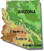
Shrublands: The Walnut Gulch watersheds are located southeast of Tucson, Arizona, on a tributary of the San Pedro river (Figure 3). The study area comprises the upper 150 km2 of the Walnut Gulch drainage basin. There is evidence that much of the area was grassland less than 100 years ago. At the present time, shrubs dominate about 65% of the watershed. Creosote (Larrea tridentata), tarbush (Flourensia cernua), mortonia (Mortonia scabella), and whitethorn (Crategus monogyna) are the most common shrubs. The remaining 33% is still grassland, dominated mainly by black grama (Bouteloua eriopoda), curly mesquite grass (Hilaria belangeri), and tobosa grass (Hileria mutica). Elevations at Walnut Gulch extend from 1219 to 1890 m. Annual precipitation ranges from 250 to 375 mm. Watersheds selected for evaluating the different higher elevation vegetation treatments were located at: (1) the Sierra Ancha Experimental Forest above Roosevelt Lake (chaparral and mixed conifer vegetation); (2) the Three-Bar Wildlife Area west of Roosevelt Lake (high density chaparral); (3) the Whitespar (medium density chaparral), (4) Mingus Mountain (low density chaparral) and Battle Flat watersheds in the vicinity of Prescott (chaparral pilot application program); (5) the Beaver Creek watersheds along the Mogollon Rim south of Flagstaff (pinyon-juniper and ponderosa pine; and (6) Castle Creek (ponderosa pine), Willow and Thomas Creek (mixed conifer), and Seven Springs watersheds (high elevation grasslands) in the White Mountains of eastern Arizona (Figure 2). Other watersheds were instrumented elsewhere on the Mogollon Rim as the need arose (Sturmer Ridge, Rattle Burn, etc.) Data collection, storage and analyses(Back to top) The basic research approach used on all experimental watersheds was a paired watershed analysis technique. This method was used to test the effect of different vegetation manipulation treatments on streamflow, erosion, sedimentation, and water quality. This technique uses one watershed as a control, paired with other watersheds at the same site that receive a treatment that is being evaluated. On all experimental watersheds, weirs or flumes were installed and a pretreatment calibration was performed for up to 10 years before any vegetative treatment was applied. The purpose of the calibration period was to establish sound statistical relationships among the individual watersheds at each experimental site during baseline undisturbed conditions. The length of pre-treatment calibration periods is usually determined by the length of time needed to measure a series of rainfall events up to a pre-selected return interval. Storms with return periods of 25 years are often used as a benchmark for calibration, but shorter time intervals are sometimes used. Calibration periods are generally longer in arid and semi-arid environments. The accuracy length of pretreatment calibration is a function of meteorological equipment and the type of stream gaging structures. The goal is to be able to detect streamflow differences of greater than 10% at the 0.05 probability level. All stream gaging stations were equipped with continuous recording water level recorders to measure streamflow. When the first stream gaging stations were installed in the late 1950s and early 1960s, only mechanical strip-chart recorders were available for collecting streamflow measurements. As technology improved these mechanical devices were replaced with modern digital electronic computer hardware and software systems. Most major study sites (e.g. Beaver Creek, Castle Creek, etc.) were equipped with a weather station for measuring and recording precipitation (rain and snow), rainfall intensities, temperature, humidity, wind speed and direction. At a limited number of research sites, solar radiation was measured for short times where more detailed experiments were being conducted. The field data collected was returned to the office where it was summarized and analyzed. During the early phase of the program, strip chart data was transferred onto punch cards that were summarized by simple software programs to obtain estimates of the different streamflow parameters of interest. Later, as computer technology improved, the initial punch card data sets were converted to modern computer formats and stored in large databases that were further analyzed and made available to interested users. The current status of these data sets and their availability to interested users are described in more detail later in this paper. Remote sensing data A variety of techniques are available for remote sensing of soil and water resources (Lyon 1995). These are particularly useful in arid and semiarid lands where much of the soil and water surfaces are not covered by dense vegetation. These data can be readily incorporated into geographic information systems for use in land management analysis and decision-making. The important remote sensing methods include low- and high-level aerial photography using visible, infrared, thermal infrared, radar, and radiation spectra. Digital elevation model, terrain model, and line graph data are very useful in analyzing watershed resources. A variety of satellite-based sensing and data acquisition systems are now available. These include the USGS Global Land Information System, the Advanced Very High Resolution Radiometer, Landsat Multispectral Scanner, etc. Application of these technologies to water resource assessments has proven to be very valuable and successful. They can be used for planning, site assessment, management, Best Management Practices applications, water quantity and quality assessments, non-point source evaluations, erosion studies, wetlands assessments and permitting, reservoir location, and other monitoring. However, the costs and logistics associated with these technologies are quite high. |
|
|
Different treatments were applied to individual vegetation types (Table 1). These watersheds were gaged for variable lengths of time before treatment effects were statistically validated. The overall philosophy of the treatments was to modify either the vegetation or the micro-topography to increase streamflow. In the mountain grasslands, snow fences were constructed to produce deep snowdrifts that would concentrate the snow in specific locations rather than allowing it to blow across the landscape or be lost by sublimation before melting. Some of the timber harvesting treatments included clearing patches of trees so that snowfall would accumulate on the soil surface rather than in the tree canopies where it was quickly lost. A wide range of timber harvesting techniques that were of interest to managers and scientists during the early 1960s was tested. The treatments applied to mixed conifer forest consisted of removing riparian trees; converting tree stands to a pure grass cover; and harvesting timber using overstory removal and timber selection cutting, patch cutting, and harvesting designs based on single- and group-tree selection. Timber harvesting treatments tested on ponderosa pine were based on cutting irregular blocks, thinning and sanitation cuts, strip cutting, thinning by group selection, and clear-cutting. The pinyon-juniper and chaparral treatments focused on eradicating trees and shrubs using herbicides, mechanical measures, or by the use of prescribed fire and then establishing and maintaining a grass cover. The reader is referred to Baker (1999) for further detail about these treatments, the streamflow responses measured, and a description of the treatments. The responses of these upland vegetation types to different intensities and patterns of vegetation modification showed that mixed conifer forests and chaparral produced the greatest streamflow responses (Hibbert 1979). Interestingly, the conversion of dense stands of chaparral to grass in areas receiving 635mm or more of precipitation annually increased the amount and duration of streamflow to near perennial streamflow. This change in streamflow regime on treated chaparral areas enhanced the reestablishment of riparian vegetation along the banks of previously dry chaparral streams on an experimental watershed near Lake Roosevelt, Arizona (DeBano et al. 1984). Watershed information Hundreds of individual research papers have been written and published on the results of the Arizona Watershed Program. Bibliographies of these publications include over 800 from Beaver Creek alone that are available on the web site described in a following section. Additional bibliographies are being assembled for other research sites that were in the Arizona Watershed Program. The USDA-ARS Southwest Research Center has over 1,000 entries in its bibliographic database. In the mid 1970s, before modern databases became readily available, the research results obtained as of that date were often published for focus areas such as mixed conifer forests, ponderosa pine forests (Brown et al. 1974), pinyon juniper woodlands (Clary et al. 1974), and chaparral (Brown et al. 1974; Hibbert et. al. 1974). In addition, state-of-knowledge papers were also published on range management in the chaparral (Cable 1975) and phreatophyte vegetation (Horton and Campbell 1974). Capability of watershed resources(Back to top) Assessment of watershed capabilities requires a commitment at a national level to provide the scientific personnel and resources necessary for successful efforts. The best efforts in capability assessment involve long-term commitment and persistence. Although useful information can be obtained in intensive, short-term efforts, important long-term trends and capability may be missed entirely, underestimated, or overestimated. Watershed resource capability information can be obtained by a variety of methods such as those mentioned in the previous section. The key to the successful application of these data is professional interpretation by trained and experienced watershed resource experts. Development and maintenance of an adequate cadre of watershed resource experts also requires education of students at national and international scales to ensure continuity of expertise. This also includes on-going continuing education training of working watershed professionals. In the latter half of the 20th century there were several oscillations in the level of commitment and support for watershed resource expertise development. With impending shortages of water projected through the 21st century, organizations and nations need to renew commitments to ensure that adequate numbers of well-trained watershed resource professionals are available to assess the capabilities of watersheds and address the resource production and allocation problems looming in the future (Rango 1995; Neary 2000). Vacik and Lexar (2001) provided an example of watershed resource capability assessment using a SDSS. Their objective was to manage water supply yields for the city of Vienna, Austria. The foundation of their approach was a GIS database that could incorporate, process, store, and organize spatial information to feed into their decision system. Vacik and Lexar (2001) recommended that any SDSS developed for watershed capability assessment should:
Again, Vacik and Lexar (2001) emphasized that the ultimate decisions are made by the watershed resource professional, not the decision support system. Once the capabilities of watershed resources are adequately determined, the information needs be transferred to users. User groups are often very diverse in terms of their interests and technical understanding of watershed information. This step often requires considerable interpretation and condensation of output provided by SDSS's and decisions made by watershed resource professionals. Technology transfer(Back to top) Web site development In 1997, personnel from the USDA Forest Service and faculty from the University of Arizona collaborated on a project to make the research data and reports resulting from year's of watershed management research here in the southwestern United States more accessible (Young and Baker 1998). This project has been jointly supported by the International Arid Lands Consortium (IALC), the University of Arizona, and the USDA Forest Service Rocky Mountain Research Station. Its objective is to deliver this information to the public via the World Wide Web (Web) (Baker et al. 2001; Huebner et al. 2000). A web site, "Managing Arid and Semi-arid Watersheds," [NB: address at end of article] has been developed featuring information and data that can be applied to other arid and semi-arid regions in the world facing similar natural resource management problems (Baker et al. 2001). By creating this web site, resource information and data become much more accessible to interested land managers, researchers, educators, students, and the general public. |
|
|
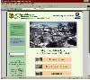
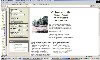
One of the challenges in developing this web site was to provide enough detail to make it useful to professional researchers and land managers and general enough for educators, students, and the general public. The first phase of the project included extensive collection of information to meet a variety of user needs (Young and Baker 1998). The basic focus in constructing this web site was to begin with introductory topics (Figures 4a and 4b) describing research watersheds, watershed management techniques, public land management issues, and to also includes background information on the Central Arizona Highlands (the green button links) (Baker et al. 2001). Other links (blue buttons) include section on a training course in watershed management developed for college students and a listing of Web resources for K-12 teachers and students. There is also information on selected aspects of watersheds, hypertext links to other related resources on the Web, and a search engine for the site. The web site is developed in a hierarchal fashion with access to the most general information and then to more specific information as one goes deeper into web site until you can eventually obtain access to actual field data (e.g., climatic, streamflow, water quality, vegetation, and wildlife) from a given research watershed. To meet more advanced needs of land management professionals and researchers, detailed resource information and actual data collected during operation of the Arizona Watershed Program (Fox et al. 2000) are available. Links (yellow buttons in Figures 4a and 4b) to seven major vegetation types in the southwestern region of the United States allow access to more specific information, including an overview section with vegetation distribution maps, description of climate and streamflow regimes, research site descriptions, watershed treatments and results, management implications of results, lists of plants and animals, actual field data, and a searchable bibliography for each vegetation type (Baker et al. 2001). |
|
|
To illustrate, clicking the ponderosa pine yellow link button (Figure 4b) and then the Beaver Creek watershed link (Figure 5), a user has access to everything from a virtual tour of the watershed (111,300 ha) and watershed statistics of specific research areas, including photographs and treatment descriptions, to the successful designation of the Beaver Creek watershed as a biosphere reserve, a component of a worldwide network of biosphere reserves in UNESCO's Man and the Biosphere (MAB) Program. Detailed information on the Beaver Creek area includes treatment prescriptions and management practices used on the various experimental areas and numerous response data collected throughout the history of the project. Data summaries are accessible both through a text index and through a "clickable" map to identify specific research sites. This web site also includes a searchable bibliography of over 800 references to technical reports and bulletins, articles, theses and dissertations, books, and proceedings that relate to watershed management in arid and semi-arid regions of the southwestern United States (Baker et al. 2001; Baker and Ffolliott 1998). The bibliography can be searched using author names, broad subject categories, vegetation types, and keywords. A searchable image database containing thousands of images collected during the years of research efforts in the Central Arizona Highlands is provided (Baker et al. 2001). Several options are available for searching the image collections using keywords, site names, and vegetation type. Hints, examples, and drop-down lists are provided to assist users. Relational database A relational database is being developed for the watershed management data that has already been collected. It includes a Web-based interface for easy accessibility of the data by potential users. In this way, the data can be used as a decision-making and teaching tool, and the database structure can be used as a template for other watershed data projects in arid and semi-arid regions around the world. Currently, there are seven data categories available from Beaver Creek: precipitation, air temperature and humidity, stream flow, suspended sediment, vegetation (range and timber), along with descriptive information about each data set. Each of these data categories has multiple subsets. For instance, the stream flow data contains subsets for daily, monthly, and annual water volumes and for major discharge flow rates. Remaining data categories, including solar radiation, wind, snow, water quality (precipitation and stream flow), and wildlife will be added eventually. We still want to develop information on how each data set was collected and summarized to assist potential users in their understanding of the data, its collection, quality, and some examples of possible uses of each data type. Some information and data for the Whitespar Experimental watersheds, watersheds in the chaparral vegetation type, are now available and data from the Castle Creek experimental watersheds (mixed conifer vegetation type) is currently being computerized for entering into the database. |
|
|
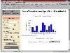
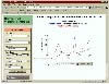
Three interfaces have been developed for accessing these data sets: a table format, a graphic format, and a map-based interface. The first allows the user to select a data category, time period, watershed, and output format. The selected data can then be viewed in a table format (Figure 6) or retrieved in a structured ASCII format that can be easily imported into a spreadsheet or modeling programs for specific user analysis. The second interface allows a graphical view of the data (Figure 7). Developing the capability to graph the data was difficult because the software available within our budget required considerable manipulation to fit the needs of this project. KavaChart requires considerable work to adjust it to our needs, and we expect to find or develop a better tool in the future. It does allow the user to plot data as a bar chart (Figure 7) or as a line graph and to plot two lines on a graph to compare two data sets (Figure 8). This latter capability is particularly effective for comparing results from a treated watershed with results from its control, or results between any two watersheds (e.g., watershed in two different vegetation types). Eventually, we hope to provide the capability of comparing two or more parameters from a given watershed (e.g., precipitation with stream flow). The third interface is map-based, allowing users to choose the watershed or stream gauge of interest and to view their associated data (Figure 9). This Web-based GIS interface has been implemented using the Environmental Systems Research Institute's (ESRI) ArcIMS Internet Map Server. Map layers for a variety of land features help users locate the area they are interested in and provide visual reference to such things as the relationship between elevation, precipitation, vegetation, and geology. The layers currently provided include towns, stream gauges, highways and roads, streams, treatments, watershed boundaries, the BCEW boundary, a 1993 Landsat satellite image, elevation, and shaded relief. This map-based interface is linked to the data interface so the user can select and view data from the same Web page. Summary and conclusions(Back to top) References(Back to top) Baker, M.B. Jr. and P.F. Ffolliott. 1998. Multiple resource evaluations on the Beaver Creek watershed: An annotated bibliography of 40 years of investigations. USDA Forest Service General Technical Report RM-GTR-13. Baker M.B., Jr., D. P. Huebner, and P.F. Ffolliott. 2001. Accessing watershed-related data sets through the world wide web. In Hydrology and water resources in Arizona and the southwest, Vol. 30, ed. M.B. Baker, Jr., 69-72. Proceedings of the 2000 meetings of the hydrology section, Arizona-Nevada Academy of Science, April 15, 2000, Tucson, Arizona. Tucson, Arizona: University of Arizona. Brown, D.E. 1982. Biotic communities of the American Southwest - United States and Mexico. Desert Plants 4:1-342. Brown, H.E., M.B. Baker, Jr., J.J. Rogers, W.P. Clary, J.L. Kovner, R.R. Larson, C.C. Avery, and R.E. Campbell. 1977. Opportunities for increasing water yields and other multiple use values on ponderosa pine forest lands. USDA Forest Service Research paper RM-129. Brown, T.C., P.F. O'Connell, and A.R. Hibbert. 1974. Chaparral conversion potential in Arizona. Part II: An economic analysis. USDA Forest Service Research Paper RM-17. Cable, D.W. 1975. Range management in the chaparral type and its ecological basis; The status of our knowledge. USDA Forest Service Research paper RM-155. Clary, W.P., M.B. Baker, Jr., P.F. O'Connell, T.N. Johnsen, Jr., and R.E. Campbell. 1974. Effects of pinyon-juniper removal on natural resource produces and uses in Arizona. USDA Forest Service Research paper RM-128. DeBano, L. F., J. J. Brejda, and J. H. Brock. 1984. Enhancement of riparian vegetation following shrub control in Arizona chaparral. Journal of Soil and Water Conservation 39: 317-320. DeBano, L.F., M.B. Baker, Jr., and S.T. Overby. 1999. Managing chaparral in Yavapai County. In History of Watershed Research in the Central Highlands, compiler M.B. Baker, Jr., 19-25. USDA Forest Service Research Paper RMRS-GTR-29. Ffolliott, P.F. and Thorud. 1974. Vegetation management for increased water yield in Arizona. Agricultural Experiment Station Technical Bulletin 215. Tucson, Arizona: University of Arizona. Fox, K.M., P.F. Ffolliott, M.B. Baker, Jr., and L.F. DeBano. 2000. More water for Arizona: A history of the Arizona Watershed Program and the Arizona Water Resources Committee. Phoenix, Arizona: Primer Publishers. Hibbert, A. R. 1979. Managing vegetation to increase flow in the Colorado River Basin. USDA Forest Service General Technical Report RM-66. Hibbert, A.R., E.A. Davis, and D.G. Scholl. 1974. Chaparral conversion. Part I: Water yield response and effects on other resources. USDA Forest Service Research Paper RM-17. Holloway, C.A. 1979. Decision making under uncertainty: Models and choices. Englewood Cliffs, New Jersey: Prentice-Hall. Horton, J.S., and C.J. Campbell. 1974. Management of phreatophyte and riparian vegetation for maximum multiple use values. USDA Forest Service Research Paper RM-117. Huebner, D.P., M.B. Baker Jr., and P.F. Ffolliott. 2000. Increasing efficiency of information dissemination and collection through the world wide web. In Land Stewardship in the 21st Century: The Contributions of Watershed Management. USDA Forest Service, Rocky Mountain Research Station Proceedings, RMRS-P-13. Judd, B.I. 1962. Principal forage plants of southwestern ranges. USDA Forest Service, Rocky Mountain Forest and Range Experiment Station, Station Paper 69. Lowe, C.H. 1964. The vertebrates of Arizona. Tucson, Arizona: University of Arizona Press. Lueng, Y. 1997. Intelligent decision support systems. Berlin: Springer-Verlag. Lyon, J.G. 1995. Remote sensing and geographic information systems in hydrology. Chapter 11 in Environmental Hydrology, eds. A.D. Ward and W.J. Elliott, 337-368. Boca Raton, Florida: Lewis Publishers. Neary, D.G. 2000. Changing perceptions of watershed management from a retrospective viewpoint. In Land Stewardship in the 21st Century: The Contributions of Watershed Management, tech. coords. P.F. Ffolliott, M.B. Baker, Jr., C.B. Edminster, M.C. Dillon, and K.L. Mora, 167-176. Fort Collins, Colorado: USDA Forest Service Proceedings RMRS-P-13 Pase, C.P. and D.E. Brown. 1982. Interior chaparral. Desert Plants 4:95-99. Rango, A. 1995. A look to the future in watershed management. In Watershed Management: Planning for the 21st Century, ed. T.J. Ward, 15-22. Proceedings of the Symposium, Watershed Management Committee, Water Resources Engineering Division, American Society of Civil Engineers, August 14-16, 1995, San Antonio. Rich, L.R., and J.R. Thompson. 1974. Watershed management in Arizona's mixed conifer forests: The status of our knowledge. USDA Forest Service Research Paper RM-130. Young, D.J. and M.B. Baker Jr. 1998. Management of semi-arid watersheds: Technology transfer. Hydrology and Water Resources in Arizona and the Southwest 28:81-83. Thompson, J.R., O.D. Knipe, and P.M. Johnson. 1976. Windbreaks may increase water yield from grassland islands in Arizona's mixed conifer forests. Hydrology and Water Resources in Arizona and the Southwest 6:323-329. Vacik, H. and M.J. Lexer. 2001. Application of a spatial decision support system in managing the protection forests of Vienna for sustained yield of water resources. Forest Ecology and Management 143:65-76. |
![]()
(Back to top)
Daniel G. Neary, Rocky Mountain Research Station, Flagstaff, Arizona 86001;
Email: dneary@fs.fed.us
Leonard F. DeBano, The University of Arizona, Tucson, Arizona; Email: debano@ag.arizona.edu
Malchus B. Baker, Jr. (deceased), Rocky Mountain Research Station, Flagstaff, AZ 86001
Managing Arid and Semi-arid Watersheds
http://ag.arizona.edu/OALS/watershed/index.html
About the Arid Lands Newsletter