Using geospatial technologies to develop
participatory tools for natural resources management
![]() No. 53, May/June 2003
No. 53, May/June 2003
Using geospatial technologies to develop
participatory tools for natural resources management
| This image depicts a satellite photo of one of the project's study areas. In this example, the local participants in the project have begun to draw lines on the photo marking the boundaries they perceive between one agroecological zone and another. This is another important step in producing a final agroecological zone map that combines local knowledge with geospatial data. | 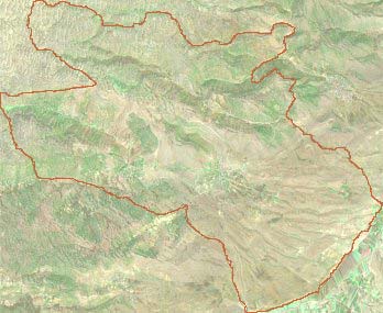 |