|
|
|
MEMP Homepage |
Sustainable Technology Transfer
|
The Malawi Environmental Monitoring Program (MEMP) is being proposed to monitor the potential environmental impacts of increased smallholder production of burley tobacco brought about as a result of the Agricultural Sector Assistance Program (ASAP) policy reforms supported by the United States Agency for International Development (USAID). MEMP will focus on the effects smallholder burley tobacco production has on both the socio-economic processes and natural resource base in Malawi.
MEMP monitoring activities shall be carried out in five small catchments considered indicative (but not necessarily representative) of smallholder burley tobacco production. Casual linkages between changes in land cover, smallholder income, soil erosion, sediment yield, cropping patterns, etc. will be monitored.
MEMP will be a collective effort based on effective cooperation between DREA and five line ministries while capitalizing on the GOM's well deserved reputation for data collection. The goals of this project therefore will be:
(a) to strengthen the technical capability of DREA and all the participating line ministries to more effectively carry out the routine tasks for which they are responsible; and
(b) to strengthen the efficient flow of information between collaborating ministries.
To meet these goals and to assimilate the data demanded for environmental monitoring, new efficient and effective techniques and solutions are called for. New information technologies that manage geographic information offer such a potential for the managers of our environment and will be implemented as a subactivity under MEMP within each of the participating agencies. Until recently, however, the implementation strategies of such tools have concentrated almost exclusively on their technical virtues with only minimal attention given to the technology's organizational and institutional impacts. Thus, the success of the technology transfer component under MEMP will be determined by the extent these issues are addressed.
For the most part environmental data in Malawi are not collected and disseminated in any coordinated or timely fashion. The use of information technologies such as GIS offer quick and powerful manipulation of data, new scenarios to be analyzed, data to be efficiently managed and brought together into a meaningful whole. The hope for implementing these new technologies will be to capitalize on current capacities and capabilities within the Government of Malawi.
Growth in Malawi's agricultural sector has been impressive, but it has been primarily commercial estate based, not smallholder based. The real value of estate production grew by 5.2 percent per annum during the 1980s compared to smallholder production real growth of 0.4 percent. As a result, the benefits of overall growth have not accrued to the overwhelming majority of Malawi's rural population.
The low smallholder growth rate is indicative of conditions amongst customary landholders. Malawi's customary agricultural sector has become increasingly crowded, and is now characterized by very small farms -- 55 percent have less than one hectare which is insufficient to supply the family's basic nutritional needs -- and more than 80 percent have less than two hectares. Credit, inputs, and extension services only tend to find their way to a limited number of farmers due to limited resources. As a result customary landholders generally have difficulty participating in the cash crop economy.
The Agricultural Sector Assistance Program (ASAP), with support from the United States Agency for International Development (USAID), was designed to increase customary smallholder access to inputs, output markets, cash crop alternatives, and labor market information. ASAP is supporting Government of Malawi (GOM) reform initiatives in these areas, as well as the implementation of discrete project activities. The initial focus of the ASAP policy agenda is the liberalization of smallholder burley tobacco production on customary lands.
Malawi is the world's second largest exporter of burley tobacco making it Malawi's premier cash crop. Burley accounts for 60% of Malawi's tobacco exports and 45% of total commodity exports. Consequently, it has become the best opportunity for smallholders having the highest return of any crop per hectare. Recent estimates show that just under 50% of the population is sustained from overall tobacco production.
With 27 percent of Malawi's arable land on steep slopes and with a population density exceeding 225 persons per square km of cropped land in some parts of the country, soil erosion, especially in the Southern and Central Regions, is a serious and growing problem. This heavy erosion is primarily the direct result of increased cultivation and deforestation. Although flue-cured (fired) tobacco requires substantially more forest resources, burley must be dried in curing sheds requiring poles and thatched roofing. In either case, tobacco production has contributed to Malawi having one of the highest rates of deforestation in Africa. These problems have been heightened by the recent influx of approximately 1 million refugees fleeing the civil war in neighboring Mozambique.
Increasing burley tobacco production is intended to improve the income of the rural smallholders, but may in fact further compound negative environmental trends. Recent reports have linked smallholder burley tobacco production with the displacement of established food crops such as maize and sorghum along with damaging crop rotation patterns, including over cropping in order to 'cash-in' on the lucrative market. Government policy for burley production seeks to gradually increase production commensurate with available resources, including extension programs, but it is currently estimated that in some areas up to 70% of production ignores established guidelines for tobacco production. This undermining can increase the difficulty in monitoring production, because, as is often case, this form of production has its own distinct crop input, management and marketing strategies.
The need to monitor the impacts of burley tobacco production is self-evident, and as a result, the GOM has mandated The Department of Environmental Affairs (DREA) to assess these impacts. DREA, residing in the Office of the President and Cabinet, is responsible for assisting ministries, departments and other organizations develop and coordinate policies that help to protect the environment and sustain development. DREA is expected to monitor all ongoing or proposed development activities in Malawi to determine whether they have, or may have, any significant effects on the environment. Where negative environmental effects occur, or are anticipated, the Department will undertake environmental impact analysis to identify the effects in more detail, and if possible, quantify and qualify them and thereafter make recommendations on appropriate action to be taken to reduce the negative effects to an acceptable minimum.
DREA, however, as well as the GOM, is infrastructurally ill-equipped to monitor such impacts. Many government agencies already collect vast amounts of environmental data but it appears at present that there is limited synthesis or analysis of the current data for environmental monitoring, let alone data needed in the future. Although, Malawi does have at its disposal a highly dedicated and capable cadre of environmental manager, a recent report suggests the need for increased information systems management to assist in the coordination of the multi-sectoral effort to monitor environmental impacts due to burley tobacco production policy.
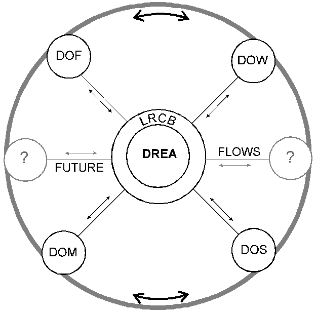
The Malawi Environmental Monitoring Program (MEMP) has been piloted within DREA to address this concern. Involving many government agencies besides DREA, MEMP is intended to be the forerunner of a reporting mechanism for the GOM on environmental impacts. In its initial phases, MEMP will establish procedures for a reporting mechanism with the following agencies: Land Resources and Conservation Branch (LRCB) in the Ministry of Agriculture, Department of Water (DOW), Department of Surveys (DOS), Department of Forestry and National Parks and Wildlife (DF/NPW), Department of Meteorology (DOM). The procedures will initially focus on the environmental impacts of burley tobacco production due to the ongoing government policy reforms, but in the process, a coordinated stream of information with wider implications will be supplied to decision makers throughout the government.
It is also proposed that geographic information technologies, such as GIS and remote sensing, assist in the integration of the vast amounts of data to be collected and aid in fulfilling the coordination mandate for MEMP. However, while interest is heightened in Malawi for the use of these new technologies, the few operational activities are quite isolated and uncoordinated from one another, and for the most part, ineffective. There is need, therefore, for coordinated support for the sustainable transfer of GIS and remote sensing activities for environmental monitoring in the form of: training, hardware, software, and technical support, and especially in the institutionalization of the technology.
To assist DREA and the five line agencies perform MEMP related activities use will be made of newer geographic information technologies. The MEMP system will entail a significant amount of coordination planning, and analysis across many government agencies. The use information technologies will seek to enhance this process. What is outlined below will allow these agencies, in a coordinated fashion, to analyze data and provide the information in contribution to MEMP, and in the long-term, provide the important elements for a broader national-level environmental information system.
Geographic information technologies such as GIS, remote sensing, and global positioning systems are computer aided tools for the collection, storage and analysis of geographic phenomena. These tools, collectively, offer the potential for a higher degree of access to geographic information, for efficient and effective geographic information management and analysis with greater precision than previously used methods. Ultimately, the use of these technologies provide environmental decision makers with more timely and accurate information.
It should be recognized, however, that GIS and remote sensing technologies, specifically, in developing countries have not met with the expected success in trying to alleviate environmental natural resource problems. In part this can be attributed to a number of 'hard' technical issues such as the difficulty in software and sophisticated technologies, user interfaces and the lack of proper training. These factor, for the most part, have been addressed through significant technological advancements.
More substantial explanations, however, have to do with 'soft' issues of technology transfer, specifically two issues: (1) the way in which the technology is demonstrated and applied, a clear failure of most initiatives to deal with specific ongoing problems and to demonstrate the technology in solving these problems; and (2) the way in which the technology is configured within an institution, a more intricate and difficult explanation that involves a significant understanding of the organizational makeup and the decision making processes of the institution to which the technology is to be transferred. These two issues will be given the focus for technology transfer implementation in Malawi. To the extent to which these issues are addressed will they determine the program's success.
Methodologically, the technology transfer program in Malawi is designed around an alternative implementation strategy. Most implementation strategies are characterized by a centralized, top-down approach with a significant reliance on external resources and newly instituted mandates. The methodology for the Malawi technology transfer component of MEMP will be one characterized by a bottom-up, decentralized approach with reliance on existing internal environmental management mandates within each of the line agencies. Although DREA will coordinate overall, DREA and the GOM will be dependent on these line agencies' contribution to the program. Appendix II illustrates this relationship and also reflects the current agencies' structure.
To overcome the dilemmas of the top-down approach to technology transfer, the goals for the Malawi program are:
The methodology for attaining these goals will be through adoption of new technologies within ongoing institutional frameworks. This research will not attempt to claim ad hoc successes through simple enumeration of hardware, trained personnel and maps. Moreover, this research will not attempt to supplant current institutional capabilities. It is instead, a long-term commitment to the transfer and adoption of information technologies in order to strengthen and engage the community of environmental managers in Malawi to make better decisions. By community, we do not only refer to the technicians employing the tools, but most importantly, the decision makers and end-users of information. Our methodology for sustainable technology transfer depends on the incorporation of an amalgamation of users to provide both the scientific and technical basis for the new tool's adoption and the understanding of relationships found within the adopting agencies. The means by which we will characterize and evaluate 'success' will be tied to how; (1) the organizations utilize these new technologies, and (2) the information they provide for environmental and natural resources management.
In the end, benefits and success of the technology transfer process will be realized if the technology contributes to the realization of each of the line agency's goals and objectives which is initially to supply data to MEMP related activities. The identification of these objectives and the information products needed from the technical system will be a result of a collaborative process between all the relevant stakeholders having access to the technology -- staff, decision makers, technicians, and even the catchment communities. Thus, success will also be attained and measured to the extent that the decision makers are involved in the technology transfer process and utilizing the information products generated specifically for the MEMP decision making process, and in general, for the management of natural resources and the environment. We can expect full support for the implementation program, and success, within each of the line agencies if all relevant stakeholders are involved in the process.
Ultimately, technology shapes almost all aspects of how things are done in an organization, not just what is done. Thus, implementation of GIS -- like any other technology -- is not just hardware and software procurement, but ultimately adoption of a process that results in the technology becoming a functional part of the organization.
The technology transfer program in Malawi follows an incremental approach for the transfer of such tools such as GIS and remote sensing. The initial phase of the technology transfer process is technology orientation. Its objectives are two-fold. First, to establish a baseline level of technical capability that can be used to evaluate the technology. Second, to increase general awareness regarding the technology and its potential at the decision making level. Together, a highly trained technical staff and the decision makers within each of the agencies will be involved from the beginning to fulfill the mandates for MEMP.
To begin developing technical capacities, exposure of a small representative group from each of the line agencies to the technology will be facilitated through training and workshops. The technology has potentials that are both positive and negative and to ensure an informed evaluation, a cadre of technicians will be trained to initially assess these potentials. Each of the line agencies will identify two trainees that will carry-on through the life of the project. These candidates will be required to attend all formal training programs, as many as three two-week courses per year. The trainees will not be required to have a computer background. In preparation, however, for the introductory GIS training program, each trainee not having a computer background will complete a two week short-course at the Ministry of Finance's Data Processing Center on Introductory Computers and Windows. The first in a series of GIS and remote sensing training and workshops should be held in Spring, 1994.
Introductory training will be largely analytical, conveying the principles, capabilities, and limitations of GIS and related technologies. Initially, the trainees will develop a minimum-purpose, analytical system that addresses a specific problem within their respective agencies in contribution to MEMP. An example would be the DOF to fully georeference and automate its inventory capacity with an analytical application directed toward forest biomass modeling in relation to burley production, current and future. This approach will develop local capacities and demonstrate the use of the technology for solving relevant problems. This initial focus of the training has disguised benefits and will thus facilitate: (1) a quick and useful in-house demonstration project with limited data collection; and (2) quick development of an in-house GIS capability.
Ultimately, development of more elaborate and extensive systems may be undertaken, but only when there is sufficient demand to support them and the appropriate institutional capacities have been developed to absorb them. The process will evolve in phases and will reflect the evolving organizational goals and human capabilities within each of the line agencies.
In addition to the technical issues to be addressed there will also be an emphasis on the organizational issues surrounding the GIS technology transfer throughout the training process. This aspect will emphasize GIS as a decision support tool rather than a technical black box. The trainees themselves will facilitate a process by which the decision making capabilities of the technology are heightened within their respective agencies. Initially, this will be carried out through sensitization programs. To facilitate this process, immediately following the GIS introductory training, site visits to each of the five line agencies will ensue for the purpose of organizational sensitization, especially with the decision makers.
As outlined in an earlier section, each of the line agencies have specific requirements to fulfill for MEMP. During the initial training stages provisional teams will be established across the agencies that will be instrumental in fulfilling these requirements. These teams will prove important in order to share resources, data and information across line agencies and other government departments. This group will be able to assess benefits and limitations of the technologies, identify additional needs, and enlist support from other interested parties. Specifically, these teams will provide the following information for each of their agencies:
Initially comprised of those directly participating in the training, at later stages these teams will become the basis for a broader user group committee, including decision makers. A larger coordinated effort is essential to move toward the establishment of a broader more comprehensive national environmental information system.
In addition to the immediate environmental data needs of MEMP, as stated earlier, international organizations are promoting programs for the development of national environmental plans and environmental information systems. To support such efforts, it is necessary to effectively and efficiently gather and analyze vast amounts of environmental and socio-economic data. Malawi is confronted with this urgent need to establish such a national system. In keeping with the bottom-up MEMP methodology and building on its decentralized base, we propose to broaden and deepen the capabilities within key ministries that will allow them to routinely assess environmental conditions at the national level. Specific goals will be to: (1) establish a national level committee to assess the use of information technologies for environmental monitoring; (2) establish work groups from within line agencies that can be assign specific fact finding tasks related to establishing a national information system; and (3) broaden the decision making process that incorporates and utilizes information products from the system.
The training program, application development and institutionalization of information technologies within each agency will be an ongoing activity over the life of the project. As each agency develops their capacity to use the technology, advanced training and individual involvement and collaboration will become more prevalent in order to develop specific analysis and reporting capacities. However, as a system working within a dynamic organization, it must continue to evolve after the initial implementation to meet changing objectives and human skills. It will thus need continual monitoring, evaluation, and support.
A mid-term evaluation will be conducted, Spring 1995, to determine if the technology addresses the demands of MEMP, i.e., if it is delivering the expected results to the decision makers within the GOM. Positive factors contributing to the decision making process, as well as negative barriers, will be determined. Also important in the evaluation process is the system's accessibility to analysts and decision makers, user performance, and overall technical performance. In all likelihood, users will not work with the system efficiently, and may abandon it altogether, if the system is not meeting its stated and anticipated objectives. Adjustments should be expected, at the very least, due to rapidly changing technologies.
|
|