
|
|
|
MEMP Homepage |
ENVIRONMENTAL REPORT
|
Executive Summary
*
Introduction *
Background *
Sources of Information *
Assessment of impacts *
Conclusions *
Recommendations *
Environmental Report*
"Are the makers of such policies (market liberalisation) aware that we are suffering now?" Blazio Jairosi, Village Headman Kasale Village Group Meeting, January 1999
*
Introduction *
Background to Study *
Purpose of Study *
Description of the Study Area *
Methodology *
Emerging Themes *
Key Questions and Findings *
Conclusions *
Recommendations *
Annexes *
Bibliography *
This report is the result of a negative determination from the Initial Environmental Examination of USAID’s Agriculture Sector Assistance Project (ASAP) which among other policy reforms, provided the opportunity for smallholder farmers to enter directly into Malawi’s lucrative cash crop export sector. The report is specifically written to meet USAID’s environmental reporting requirements developed as part of USAID’s Environmental Monitoring, Evaluation and Mitigation Plans (EMEMP). The report and methodologies used to complete it reflect several efforts to assess the impact of policy reform that began in 1993 with an intensive study of water quality in small watersheds. The results of the earlier in-depth intensive data collection are reported on in a separate document recently completed by the Environmental Affairs Department.
Investigations for this report were carried out at a time when a number of changes, triggered by a set of macroeconomic policies, including the agricultural reform policy and other national events were starting to take effect. Key among them were the shift to multi-party democracy, the implementation of fiscal reform measures, and the removal of pricing subsidies. Each had different impacts but the central ones ranged from the collapse of the mechanisms for the enforcement of natural resource laws and regulations, the devaluation of the local currency, and the significant increases in the pricing of fertilizer. Many of these changes occurred in 1994 and resulted in a number of cross cutting environmental and social impacts which make the assessment of a single policy reform measure difficult to isolate and assess. In addition, environmental change, like else where in the world, is an ongoing process often accelerated by policy changes.
A number of the findings from this assessment are not only related to agriculture policy reform, but to the pursuit of improved environmental management through Malawi’s current cross-sectoral natural resource policy and legislative reforms under the NATURE program. These include the apparent lasting effects of Malawi’s political history resulting in low levels of community organization and a distinct lack of initiative on the part of some communities members and their leaders to seek local solutions to declining local and hinterland environmental conditions.
[ Table of Contents]This report draws information principally from three sources. First, analysis of national level trends in water quality changes including sediment loads and pesticide prevalence are summarized from the recently completed Water Quality Report of the Lake Malawi/Nyasa Biodiversity Conservation Project. Secondly, a specific assessment of the impact of agriculture practices under different cropping systems, analysis of water quality from farmers fields, and control plots was drawn from the Final Technical Environmental Monitoring Report using data collected during the 1998/99 growing season in the Kamundi catchment.
Finally, quantitative assessment and qualitative characterization of environmental change was conducted in the Nsipe Extension Planning Area (EPA) during the 1998/99 growing season by Clark University, the University of Arizona, the Department of Forestry, and Bunda College. While the four catchments selected in 1993 for purposes of monitoring policy change, ultimately showed increases in two catchments, the Nsipe EPA has a history of cash cropping predating policy of market liberalization and continuing to the present. It was selected as a representative site where the impact of market liberalisation on the environment could be carried out. This followed a four year period of inconclusive results from earlier monitoring efforts carried out by the Environmental Affairs Department (USAID/Malawi 1995).
The two reports, Water Quality Report of the Lake Malawi/Nyasa Biodiversity Conservation Project and Final Technical Environmental Monitoring Report though separate in terms of time and scope provide complimentary evidence used to answer the question regarding environmental change. When considered together with the results of the Nsipe EPA study the contributory effect of market liberalization to environmental change is established.
Methodology for Assessment of Impacts
Studies on water in large and small watersheds were based on monitoring and measurements of actual the Nsipe study used a methodology that coupled macro and micro levels of environmental analyses. Developed by Clark University in the early days of MEMP, the methodology entails the use of satellite image analysis in the initial instance to establish and locate environmental "hot spots" such as severely deforested landscapes. Once the "hot spots" are established explanations for the changes are sought at micro level involving the local farmers. At this level participatory research methods are used to explore explanations of some of the "hot thematic changes" noted by micro level analysis.
The major findings relating to the specific questions raised in the Initial Environmental Examination and the processes referred to are grouped under aquatic and land use impacts.
Aquatic impacts
Records in the Water Quality Report show an increase in the import of agro-chemicals from 1990 to 1992 but the same report does not distinguish between imports for use by Malawi’s agricultural sectors. Regardless, there has been subsequent to 1992, a decline in fertilizer use by small holder farmers due to an increase in price resulting from the removal of subsidies . Initially, fertilizer application has been exclusively on cash crops and high yielding maize varieties. A change was noted in the late 1970s and early 1980s when the use of fertilizer on maize by smallholder farmers became a widespread phenomenon. This was due to the availability of subsidized fertilizer accessed through Maize Clubs. Smallholder farmers in Nsipe refer to this period as the "golden age of rural farming" (Focus Group Discussion, Khuzi Village, January 1999).
Recent declines in the fertility of the soil accompanied by declining yields have convinced farmers of the centrality of fertilizers to their farming enterprises. There has been a further shift though by farmers with sufficient income to increase fertilizer applications to non-cash crops (i.e. maize) while those without are clamoring for government assistance in he purchase of fertilizer (Personal communication).
The Water Quality Report summarizes a project study showing low levels of persistent pesticides, organophospahtes and organocholrines in Lake Malawi. In addition, the levels of persistent pesticides in the tissues of fish species consumed by humans are also within acceptable limits. "Concentrations of persistent pesticides, PCBs and mercury in most fish from Lake Malawi are low. DDT is the most predominant organochlorine found in these fish, and was found at the highest concentrations in fish high in lipid and in the top predators of the lake."
Analysis of water and soil samples taken from the Kamundi Catchment reveal the presence of organophospahtes and organocholrines which are most likely persistent residuals of aldrin and/or deldrin.
Water quality can be separated between that for Lake Malawi and the Shire River as there is relatively little outflow from the Lake to the River compared to surface and deep water mixing within the lake itself. Therefore while there is considerable concern over siltation and the impact on hydroelectric facilities along the Shire River, the concern for Lake Malawi is the impact of sediment on the nutrient balance and budget for the fisheries of the lake and how it may effect biodiversity. The Water Quality Report indicates that sediment delivery by the rivers flowing into Lake Malawi has been increasing since1983. The report identifies what are termed ‘disturbed’ and ‘undisturbed’ rivers and for the former the Dwangwa and Linthipe have experienced considerable agriculture expansion which, in conjunction with increasing population pressure and land clearing explain the increasing sediment delivery into the lake. Both the Linthipe and Dwangwa have areas of cash cropping much of which is associated with large estates and the expansion of small estates during the 1970s.
"The southern Linthipe and Dwangwa are the largest riverine contributors of N and P to Lake Malawi/Nyasa. These rivers also have the most variable flows and significant outputs of nitrate and sulfate. Nitrate release is characteristic of catchments losing vegetative cover while sulfate is yielded from wetlands when they are drained and disturbed. The most disturbed southern catchments are exhibiting higher suspended sediment, total phosphorus, and total nitrogen maximum concentrations which are 10, 5 and 9 times higher respectively than concentrations in rivers with less extensive agriculture and land use clearance."
"The estimated inputs of critical nutrients, nitrogen (N) and phosphorus (P), from rivers are much higher than previously estimated. Phosphorus inputs from all rivers are three times higher than previously thought, while nitrogen is six times higher."
Contrary to what had been expected, but of concern in relation to the above findings, the small catchment studies at Kamundi from 1998/99 indicate higher nitrate and phsophorus losses in maize crops than the burley.
The field work at Kamundi indicate that contour ridges and vetiver grass in both maize and burley tobacco plots significantly reduced runoff and losses of soil and nutrients which resulted in less pollutant loading in receiving streams. As would be expected, the bare soil runoff plots with no ridges produced the most runoff, followed by the maize plots and then burley.
The small catchment studies collaborate the large catchment findings from the Lake Malawi/Nyasa Biodiversity Conservation Project, that accelerating change accompanying agriculture expansion and population pressure are of as much concern as environmental change that could be attributed to market liberalization.
Landuse Impacts
The Nsipe EPA study, though concentrating on purely qualitative data, was able to establish that there are some changes in both water quality and quantity. While issues surrounding water quantity are explained through annual deficits, those relating to quality were only noted through changes in the taste and odors in the water. Such changes were claimed in one major tobacco-growing village – Semu Chimwala.
This question was addressed in Nsipe EPA study through a combination of biophysical and social analyses. The study established that the cultivation of marginal and unsuitable areas was a function of how mechanisms for the enforcement of natural resource laws and regulations were managed by the various governments from colonial to the post-Banda government of today. In the post-Banda period, which coincided with market liberalization, environmental legislation was quietly ignored. Regardless, the study showed that there was limited agricultural expansion into these areas. Where expansion did take place (as in Khuzi village), the farmers claimed they were driven by poor quality soils, increasing household members, inequalities in the distribution of land, and landlesssness and not necessarily by the desire to grow cash crops.
Market liberalization did not singly contribute to agricultural expansion.
The Nsipe EPA study shows that this area was settled at the turn of the century and most of the land suitable for agriculture was allocated circa 1920, as part of the centralization policies of the settler colonial government. In addition, these lands have been sub-divided for family members, ruling out fallowing as a soil fertility management strategy. Further, the same lands, under the same crops (maize, groundnuts, millet, beans, and cassava) have been more or less under continuous cultivation for close to eight decades. The impact in the reduction in the lengths of the fallow periods vis-à-vis agricultural production was ameliorated in part by the introduction of high yielding maize varieties and fertilizers in the 1950s and sustained by the fertilizer subsidies of the 1970s and 80s. The negative impact could also have been further reduced by the adoption of ridging as both the primary land preparation process and a soil and water conservation measure.
For Nsipe EPA, market liberalization did not, in any way alter the trend of continuous cultivation, but affected fertility management by pushing fertilizers beyond the reach of small holder farmers.
Continuous cultivation and deforestation combine very well to create conditions for severe erosion. First, deforestation is as much a problem of the past, as it is of the present. Deforestation was noted as taking place in the riverine areas, open grazing areas, as well as arable lands. The reasons for tree loss are many and varied. Notable among them, is the ever-increasing demand for fuel wood for use in the household, village industries, and for sale outside the village. Secondly, continuous cultivation as already noted, is a feature of the farmers’ agricultural practices. While continuous cultivation has rendered the soils friable, ridging has compacted the soils in between the ridges, creating perfect conditions for excessive run off.
The combined effects of tree loss and continuous cultivation are leading to widespread erosion across the EPA.
Farmers claim that market liberalization has contributed to deforestation through the opening up of markets for wood and wood by-products. Farmers are particularly concerned about the continued removal of trees along riverine areas.
The claim that the construction of tobacco sheds has contributed to deforestation is not a robust argument as most tobacco farmers build semi-permanent structures that last up to three years. As for mitigation measures against soil erosion the study noted that there is knowledge among farmers that box ridges reduce soil loss. More significantly, they are seeking alternatives to fertilizer, hence the resurgence of soil fertility approaches such as the incorporation of crop residues, application of animal manure, and composting.
There is nothing to suggest that increased rural incomes are leading to the adoption of soil and water conservation practices. There seems instead to be a conflict of interest between investing in soil and water conservation works and the acquisition of symbols of accumulation. Incomes earned from the sale of tobacco by farmers in Semu Chimwala, Khuzi, and Pheza are used to buy bicycles (considered as multipurpose machines), radios, and other household goods. Food also features as a major expense item.
The failure to invest in soil and water conservation works is partly due to the fact that most of the tobacco farmers belong to tobacco clubs and obtain fertilizer through credit. Thus entrenching the view that soil fertility problems can be solved through the use of fertilizers.
Where an investment is made, it is in the form of hiring labor to make and/or repair ridges – an activity that is tantamount to land preparation under any other land use system. Thus investments in soil and water conservation works are hardly noticeable.
Although this question was part of the Initial Environmental Examination, it was discussed with USAID and in the light of the apparent lack of evidence of non-biodegradable plastic material in rural areas as not critical to the assessment.
[ Table of Contents]Market liberalization had both negative and positive impacts on the environment. The conclusions drawn here are based on the Nsipe Study as well as other documents that were available.
The fact that the enactment of market liberalization coincided with democratic changes, the rise of the mwachifuniro chake ethic among smallholder farmers, and the lack of enforcement of conservation law, the overall environmental impact of market liberalization is rather unclear.
This report integrates information generated by two separate but complimentary processes. On one the hand are the findings on the trends in water quality contained in the Water Quality Report for Lake Malawi/Nyasa Biodiversity Conservation Project and Assessment of Agrochemical Impacts on Surface Water in Kamundi Catchment detailing point and non-point sources of pollution respectively. Albeit, this was done in the absence of any integrated report from four years of intensive monitoring in four small catchments, and the absence of useful data from efforts to build a national monitoring program through the development of area based sampling frame. On the other hand the Nsipe Extension Planning Area (EPA) Study carried out by Clark University, the Depatrtment of Forestry, and Bunda College sought to assess both qualitative and quantitative environmental change in six villages drawn from the whole of Nsipe.
In the main the findings show that market liberalization did not have a significant impact on land cover change but altered approaches to land use and cropping patterns as farmers switched from food to cash crops (i.e. tobacco, paprika, and pepper). While increases in fertilizer prices had an immediate impact on how farmers practice agriculture the lack of fertilizer is having a positive effect on soil fertility management as farmers are actively adopting organic approaches to soil fertility.
This report is made up of six sections starting with a general background through a set of emerging themes to conclusions and recommendations.
This report is part of an overall framework designed to gain an understanding of the impact of USAID’s financial assistance to Malawi. The program in question, the liberalization of the agricultural sector, was meant to improve the overall production and marketing environment for both cash and food crops for smallholder farmers. Central to this program was the support provided to the Malawi government to enable small holder farmers primarily those with holdings of 1.5 ha or less to access the lucrative tobacco and other cash crop markets. Malawi’s agricultural system is trimodal (Mhone 1987) with a smallholder sector, located wholly within customary lands (MoG 1993), that is plagued by problems of serious soil erosion, deforestation, and general land and water resource degradation (USAID/MALAWI 1991). This sector was for a time neglected as no extension was provided (Mhone 1987). This envisaged program was to usher a new era in smallholder farming and with it a whole new suite of environmental problems. The general supposition then was that most of the degradation was agriculturally induced and the situation was likely to deteriorate due to market liberalization and appropriately a monitoring program was designed and put into place.
The concern centered on the supposition that the cultivation of tobacco by smallholder farmers would induce crop-switching, demand for more land for cultivation or increased fertilizer. The new land to be opened for cultivation was likely to be marginal or unsuitable thus inducing soil erosion while increased fertilizer and agrochemical use would lead to water pollution. In the same vein it was thought that any expansions in agricultural land and the construction of tobacco sheds would increase deforestation. It was also noted that the tobacco plant is heavy on plant nutrients and provides poor soil surface cover during the early days of the crop thus requiring adequate physical conservation measures (Goodland, Watson and Ladec 1984). The poor state of soil and water conservation in the farmers’ fields was noted but it was thought that the farmers would use the higher incomes from tobacco to establish soil and water conservation works on their lands.
Soil erosion, deforestation, and related environmental change processes are located at the confluence of ecological and social systems (Holling et al. 1995). The interactions and linkages that exist between social and ecological systems mean that as one of the systems changes so does the other. Thus environmental changes that may occur in a given place and time may b due to the processes outlined above but may be accelerated by external and/or internal shocks. For example macroeconomic policies have been known to trigger widespread environmental degradation (Young and Solbrig 1993). Following this line of thinking one could argue that the overall performance of both ecological and social systems at the micro level is determined by the macroeconomic policies in place. In addition, interactions between ecological and social systems also occur in a historical time frame and thus it is imperative that the environmental history of a given place be understood (Worster 1990). In studying the process of environmental change, one must fully understand the evolution of the policy environment, the environmental history, the impacts (intended and unintended), and the related political issues and events. This thinking provided an important underpinning to this study.
[ Table of Contents]"Serious soil erosion, deforestation, and general land and water resources degradation taking place in Malawi without being properly monitored." (USAID/MALAWI 1991)
The Nsipe EPA study sought to provide an in-depth analysis of the environmental impacts of cash cropping by smallholder farmers. One of the guiding assumptions of the introduction of cash crops among smallholder farmers, especially tobacco, was that there would be widespread environmental degradation. In order to counter this obvious impact an environmental monitoring program, known as the Malawi Environment Monitoring Program (MEMP) was put into place. The monitoring program described below sought to understand the environmental impacts of cash crop growing and in particular burley tobacco.
The Government of Malawi developed the MEMP program in conjunction with USAID advisors as part of the Evaluation, Monitoring, Evaluation and Mitigation Plans (EMEMP) process. Details of the evolution of the MEMP program are summarized in the Final Report for MEMP II. Briefly, prior to the post Banda era, Malawi was seen as a country rich in data and poor in information or reporting products. Technical assistance was to provide assistance in analyzing, interpretation, and reporting of cross sectoral data collected by technical agencies from four small catchments averaging about 1,000 hectares in size.
Due to the need to collect new data to monitor change associated with policy revision, the MEMP quickly became an intensive data collection program rather than a technical support activity to improve environmental analysis and reporting. Efforts to streamline data collection, or make it more representative of Malawi as a whole, through the development of an area sample frame, were impeded by technical and institutional limitations. As a result, only one report for one small catchment was produced in four years. A final report that summarizes the available data from the MEMP activity was produced recently as part of the closure of the project.
As the first report was only seen as establishing a baseline, and in the absence of any conclusive findings subsequent to the initial report, a more focused study in an area with a known history of cash crop cultivation was deemed essential. Such an area, once chosen would help to explain, through the examination of cropping and production figures, the impact of market liberalization on both the environment as well as the smallholder farmers themselves. Such a study was planned for the Nsipe Extension Planning Area during the 1998/99 growing season.
The Nsipe EPA sought to establish, through a two pronged methodology linking macro and micro levels of environmental analysis, farmer based explanations of environmental change. In addition, the study sought to understand the political and economic actions carried out by the farmers in response to market liberalisation, the perceived impacts of the actions, and the farmers’ collective futuristic vision of their environment.
This report presents some of the study results as well as a social and environmental analysis of change across the Nsipe EPA.
[ Table of Contents]The Malawi National Environmental Action Plan ranks soil erosion as the county’s number one environmental problem (DREA 1994). According to DREA the areas that are most affected are the customary lands where 85% of Malawi’s population resides. In these areas agriculture provides both income and employment (Kapila and Mwafongo 1995). The average land holding is less than 1 ha/household and the farmers have over the years experienced reductions in yields, increasing soil loss, and low returns from agriculture. In a bid to stimulate this sector smallholder farmers were, in 1994 as part of a market liberalization process allowed to engage in cash cropping, especially burley tobacco. The vision was that the farmers would not only realise higher returns for their efforts but also use the returns to construct and maintain robust soil and water conservation measures.
Nsipe Extension Planning Area (EPA) is located in the Ntcheu District, 190km from Lilongwe, the Capital of Malawi and was chosen for this study because of the mixed cropping that is practised there. The EPA is made up of a total of 162 villages, with a population of 23 675 people is physically a complex mosaic of arable fields, hilly areas, dambos, and patches of woodlands. It has an area of 80 000 ha of which 23.75% (or 19 000 ha) is arable. The EPA is wholly under Miombo woodlands dominated by species of Brachystegia, Julbernardia, Isoberlinia and their associates. Soils are variable, mainly sands derived from granites with sandy loams and clays in the valley bottoms. Soil loss of has been noted as a major problem. At national level the deforestation rate is given as 3.5% per annum (Soulsby 1996, SADC/SACCAR 1997). This figure shows that the woodlands are under pressure and most of it is from the ever increasing population with a growth rate of 3.7% per annum and will continue to decrease due to the increasing demand for wood and non-wood forest products.
Agriculturally Nsipe offers a mixed cropping pattern over an intricate network of ridges. The dominant crops are maize, groundnuts, tobacco, cassava, millet, and other low order crops such as beans, pepper, pumpkins, and sweet potatoes. Of note is the fact that the EPA was reported as having close to 800 peer-formed tobacco clubs (Mr. S. K. Neba, Development Officer, Nsipe EPA, personal communication). The differentiated cropping and agricultural system of Nsipe offered a good setting for the study in that the team was able to look at the overall environmental impact of market liberalisation on a diverse agricultural production system rather than a single on cash crop. More so, a better understanding of the contribution of tobacco to land use and land cover change and any other environment problems can be better understood within a differentiated and variegated agricultural landscape.
Other criteria for selecting the Nsipe EPA included a desire to demonstrate a linkage between current mitigation and implementation programs supported by USAID, the Malawi Agroforestry Extension Project (MAFE) and Small Holder Agribusiness Development Project (SADP) respectively, and the monitoring program. The monitoring program originally was developed to support the provision of data to incorporate into an Environmental Information System (EIS). Initial efforts in the development of the EIS centered on a prototype to address problems of siltation in the middle Shire River. The headwaters for the Rivi Rivi river catchment, an area previously identified as a key contributor of sediment to the Shire, were also found in the Nsipe EPA.
The monitoring of water quality changes in major watersheds such as the Rivi Rivi compliment the micro level examinations of environmental change in places like Nsipe EPA. In addition, macro level assessments of water quality such as those completed over the past two years as part of the Lake Malawi/Nyasa Biodiversity Conservation Project also help to provide a better understanding of the local. That project, while focusing on the watersheds which directly provide runoff to Lake Malawi\Nyasa, also sought to understand how changes on land use influence changes which may impact upon aquatic ecosystems and the conservation of the endemic fish species on a lake-wide basis.
Two methodologies were used. The first relates to the monitoring of water quality and the second to the Nsipe study. Although MEMP was a capacity building activity it did not achieve its goal of developing environmental data sets for small catchments. The Lake Malawi/Nyasa Biodiversity Conservation Project was able to capture data on concentrations of nutrients and suspended sediments that were combined with flow data for the major contributing rivers to Lake Malawi. These data are of importance to the original goals of the MEMP and if coupled with the small plot data collected during 1998/99 from Kamundi a relationship between off site and on site pollution sources can be developed.
The Nsipe EPA study employed a methodology that coupled macro and micro levels of environmental analysis. Developed by Clark University in the early days of MEMP entails the use of satellite image analysis to establish and locate environmental "hot spots" such as severely deforested landscapes. Once the "hot spots" are established explanations for the changes are sought at micro level through the involvement of local farmers. At this level participatory research methods are used to explore explanations of some of the "hot thematic changes" noted by micro level analysis. Such explanations vary but in the main are based on historical antecedents, land use policies, and the roles of the decision-making processes of the farmers themselves (Croll and Parkin 1992). This methodology compels that a cross-section of complimentary methods of inquiry and analyses, encompassing and directly addressing both the biophysical and social contexts of the smallholder farmer are used (Batterbury et al. 1997).
This approach was used for the Nsipe to answer a set of specific questions. The study commenced with the classification of the remotely sensed data (1994 and 1998) thus enabling the team to establish land cover changes across the whole of Nsipe EPA. In addition to change detection the study also utilized a set of criteria to select villages. This was followed by a half-morning meeting of key district officials wherein villages in Nsipe EPA were classified as per criteria according to the knowledge of the field officers. Discussions in this meeting also considered EPA and FEWS cropping data. A total of four villages were selected per set of criteria. The next step was to travel to each of the villages (24 in all) and through rapid rural appraisal techniques as well as the land cover map derived from remotely sensed data one village was selected per set of criteria. Once the villages were selected the next stage entailed the selection of Village Based Enumerators (VBEs) who formed a core of the farmer-based research and monitoring technique used in this study. A training program was mounted where participatory rural appraisal techniques and other community based research approaches were imparted to the six VBEs.
Out of the 6 villages a proportional sample of households was selected taking into account the fact that some of the villages were matri-local. A total of 231 households were studied through the use of a bifurcated survey instrument where both close and open-ended questions were asked (see Annex I). The information from the household interviews was complemented by focus group interviews, transects, historical profiles ad trend analysis. In designing this study sight was not lost of the fact that the outputs would be both a method of work and the actual analysis that was to be used to inform policy. In this manner the environmental impacts of tobacco growing were examined in the context of the land users’ experiences, land management approaches, opportunities and constraints.
[ Table of Contents]Household, focus group, and key informant interviews in conjunction with social transects, trend analysis, seasonal calendars, and historical profiles produced a set of overarching outputs that helped explain the impact of market liberalization on smallholder farming sector in Malawi. The broad and commonly recurring themes are as follows:
"I can always remind the village headman that this is my land." (Comment from a farmer during the Kasale Village Group Meeting, January 1999)
Not only does this kind of mentality erode the Village Headman’s power but it also effectively negates the effectiveness of local environmental rules and regulations. The lack of commons land to allocate has caused a power shift in the villages where the village headman’s role is now seen as in conflict resolution only.
"The village is concerned that extension workers no longer enforce the law, or even teach us like they used to do in the olden days." (Farmer, Khuzi Village Group Meeting, January 1999)
The problem is deeper than the farmers can fathom. The ratio of Field Assistant to farmer is 1:1983 (Mrs Mwandire, personal communication, October 1998) and some villages do not even have Field Assistants. Of even greater concern is the level of environmental awareness among the officers themselves that was found to be questionable especially that they were allowing farmers to site tobacco nurseries on steep slopes with little or no conservation measures in place. The apparent lack of environmental awareness may be attributed to the fact that extension as a whole is commodity driven.
"How can you say the government cannot do it. Look at the Starter program. Where did the money come from?" (Semu Chimwala village group meeting, January 1999)
With this kind of mentality a lot of work is needed to ensure that the farmers can take responsibility for their lives.
[ Table of Contents]The Study’s ‘Big Question" – What is the effect of market liberalization on the environment? The broad assumption of this study is that environmental change and degradation were already taking place in most parts of Malawi, Nsipe included, but were accelerated by a combination of market liberalization and other driving forces. The study carried out in Nsipe EPA focused on smallholder agricultural production. Environmental change in an agricultural setting was viewed as exhibiting itself through land use and cover change as well as increased levels of chemical pollution in surface water bodies. The following key findings were established.
Although the methods employed in this study do not readily answer this question, the survey instrument sought to establish some noted changes in both the quality and quantity of water. Some of the observed changes are as follows:
Household and focus group interviews addressed this question and the outcomes indicate that expansion of agricultural lands into marginal areas has been minimal. More importantly farmers point out that they have been cultivating the same pieces of land since the centralizaton policies of the 1930s (see diagram above). Expansion into marginal and unsuitable lands has tended to be event or government transition specific (refer to diagram above). Notable are the cycles of the suspension of the enforcement of conservation laws or the adoption of extension programs that often coincided with changes in governments. The following observations help to explain some of the central issues to this question.
Farmers in all the six villages indicate that they have been cultivating the same pieces of land for the last eight decades. The same pieces of land have been sub-divided to family members. Thus the land holdings per individual household are getting smaller and smaller so much so that fallowing is no longer a soil fertility management option. The issues that emerge from this analysis are:
The major land use of this area is arable farming and most changes noted center on the adoption of new crops and the subsequent crop mixes overtime. All the farmers claim that continuous cultivation has led to losses of soil fertility and structure, rendering them unproductive and susceptible to erosion. The envisaged solution to soil infertility is fertilizer while erosion is addressed through ridging. A few observations from the study are laid out below:
Deforestation is widespread in all the six villages but its effects are more pronounced in Pheza, Khuzi and Kanjati. The villages of Semu Chimwala, Pheza and to a lesser extent Khuzi blame tobacco farmers for this development. The element of individualism and the management of community property do no go hand in hand.
"We own the trees and we can use them the way we want." (Pheza Village Group Meeting, January 1999).
Statements like these do not suggest good stewardship and to some extent explain why the farmers explain deforestation as having been externally induced. Some of the explanations advanced as follows:
The adoption of soil and water conservation measure was noted as being highest in Pheza but not necessarily in Semu Chimwala that has made the most money from tobacco. Adoption of conservation measures in Pheza dates back to the 1940s, and though not related to tobacco growing and the conditions under which the adoption of these measures took place had nothing to do with investments in conservation works. The following key issues were noted.
Village selection for the study was carried out through a three-step process where land cover change and a set of criteria were used to group villages. District and Extension Planing Area level extension personnel were consulted and village crop production data analyzed. Four villages per set of criteria were selected and then through rapid rural appraisal a choice of the most representative village was made. The selection of households was less problematic. Three village lists (FEWS, EPA, and Seed Starter Pack project) were compared and their consistency established. A stratified random sample was selected per village with the assumption that a proportional representation of all sections of the community, and in particular female headed households.
The actual study used a set of methods that included transect walks, in-depth household, focus group and key informant interview, timelines, village mapping, and literature search. By working in this way the information so generated by each tool was corroborated with that from other tools. Triangulation is an essential part of participatory approaches.
The construction of conclusions to the study on the environmental impact of market liberalization of smallholder agriculture in Malawi is confounded by the advent of democracy in that country. The new wind of change triggered a set of political and structural changes and in the environment sector unmasked environmental degradation, invented the mwachifuniro chake ethic among smallholder farmers, and froze mechanisms for the enforcement of conservation laws and regulations. Besides market liberalization was part of a national structural adjustment program some of whose requirements were cut backs in the civil service that in turn affected the delivery of extension advice or even law enforcement. It is against this background that the following conclusions and recommendations are made.
STATUS OF REMOTE SENSING ANALYSIS FOR NSIPE STUDY
The Nsipe case study on market liberalization effects on the environment and rural livelihoods includes both social and land use/cover analyses. This section describes the methodologies and preliminary findings of the remote sensing analysis of land use/cover change for the Nsipe EPA.
Three time periods are utilized for this study: 1984, 1994, and 1998. With the market liberalization policies taking effect in roughly 1994, it is assumed that these dates can capture significant changes before and after the policy events. While the land use/cover analysis can show changes, however, it is premature to attribute the causes of these changes to market liberalization policies, especially in the Malawi context of a very dynamic political economy in the past 5 years. The social analysis over the next 5 months will assist in understanding the relationship between political economic events and land cover change.
To produce land use/cover change maps from 1984 to 1998, Landsat thematic mapper 30 meter resolution satellite imagery will be classified for the three time periods. To date, much progress has been made with the 1994 and 1998 imagery, and the 1984 image will be classified with the help of aerial photograph interpretation. For purposes of this study, five land use/cover categories are interpreted from the imagery:
The landscape in Nsipe is dominated by highly fragmented land management systems. That is, in a small area there is typically a mix of land covers; and thus classifying such an environment is a challenge. Because of this uncertainty, the social analysis includes village mapping and environmental histories so as to verify the generalized remote sensing results.
The preliminary results for 1994 and 1998 are displayed below. One difficulty in comparing these images is that the 1994 image is from the dry season and the 1998 image is from the wet season. It would be highly preferable to conduct this comparison with images representing similar seasons. Even so, these images begin to tell a story about how, when, and where the landscape is changing.
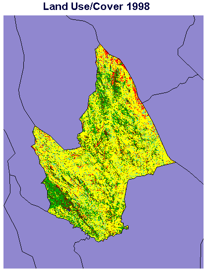
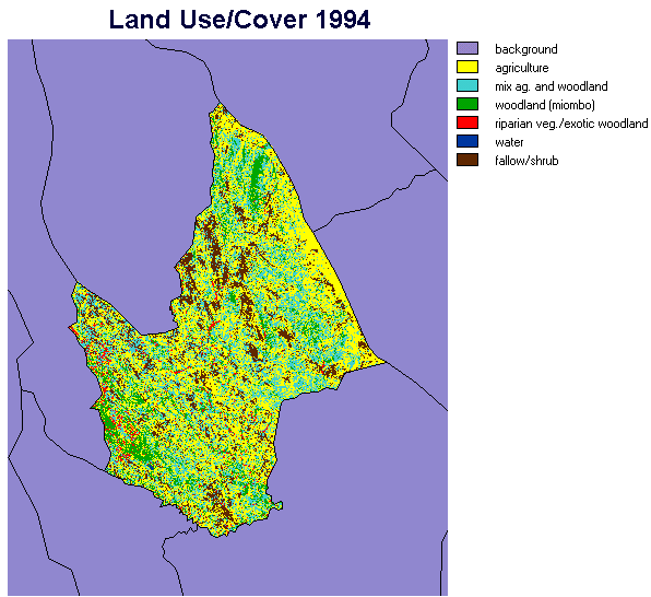
Briefly, these preliminary results show an overall decrease in the combined categories of "mixed agriculture with woodlands" and "woodlands" from 35% to 28% between the time periods. Of note, the "mixed agriculture with woodlands" from 1994 have dominantly become agriculture by 1998. Additionally, the area to the northwest of Mpira dam has experienced significant reforestation following the imposed watershed management of the area, which included the eviction of farming activities from this area. These initial maps will be ground truthed and further improved in the coming months. Additionally, the 1984 image will be classified with the assistance of aerial photography.
Annexes
Nsipe EPA 4 Study: Survey Instrument
Name of Enumerator ____________________________ Village ________________
Headman _______________________ Traditional Authority ________________
Section A: Household Profile
A1 Name of respondent_______________________
A2 Sex of Respondent (circle one) M/F
A3 Head of Household (circle one) M/F
A4 Ethnic group (circle one)
Ngoni
Yao
Lomwe
Chewa
Other, specify
A5 Religious affiliation (circle one of the following)
Christian
Moslem
None
Other, please specify
A6 If the answer to A5 is Christian to which of the following denominations does the head of household belong?
Abraham Church
Assemblies of God
CCAP
Independent Assemblies of God
Jehova’s Witness
Roman Catholic
Seventh Day Adventist
Zion
Other, specify
A7 Was Head of household born in this village? Yes/No (circle one)
A8 If the answer to A7 is No why did he/she come to this village?
A9 Where did they come from?
_______________________________________
A10 Who of the following allocated the residential plot?
Parents
Family head
Village headman
Group village headman
Traditional Authority
If inherited, from whom
Other, specify
A11 Which of the following village organizations does the head of household belong to?
Agora
Community Development committee
Farm Club, specify
Nutrition club
Tobacco club
Water committee
Other, please specify
A12 Which of these influences your decisions on agricultural practices most and why?
A13 How many household members normally reside in this household?
|
Column 1 4 |
5 |
|||||
|
Name of H/H Member |
Relation to H/H Head |
Sex |
Age |
Occupation |
||
Section B: Natural Resources Base: Land
B1 Who usually allocates land in this village? _________________________
B2 Types of lands allocated to the household.
|
Land allocated to household |
Main reason for acquisition |
Village land set aside for |
When allocated |
Period of use |
Allocated by |
Rights |
B3 Has the head of household ever extended arable land since 1994? Yes/No
B4 If Yes, why and how much?
B5 If the response to B4 is No, how has the household sustained crop production?
B6 Can you meet your household’s basic food security from the arable land(s) currently available to you? Yes/No
B7 If the answer to B6 is No, how are you going to meet the food requirements of your household?
Section C: Buildings
C1 Has the household built a tobacco shed for its own use? Yes/No
C2 Does the household share the use of a tobacco shed? Yes/No
C3 Has the household been involved in the construction of any of the following in buildings in the last 4 years?
Bathroom
Cattle kraal
Chicken coop
Goat pen
Granary
Kitchen
Pig sty
Tobacco shed
Toilet
Other, specify
C4 If labor and other materials were paid for where did the money come from?
C5 What tangible possessions (eg equipment and/or livestock) did the household
purchase in the last 4 years and which one(s) do you still in your possession?
|
Equipment/livestock |
Source of money |
Available/sold |
Section D: Household Economy
D1 What are the household’s main sources of income?
|
Major income source |
Gender of person involved |
|
Beer brewing |
|
|
Brick making |
|
|
Craft sales |
|
|
Crop sales |
|
|
Firewood sales |
|
|
Fruit sales |
|
|
Hiring out Labor (Ganyu) |
|
|
Home baking |
|
|
Livestock sales |
|
|
Off farm employment |
|
|
Remittances |
|
|
Sungwi |
|
|
Tobacco sales |
|
|
Trading |
|
|
Other, specify below |
D2 Of these which contributes the greatest percentage of the income?
D3 What are the household’s other sources of income?
|
Secondary income source |
Gender of person involved |
|
Craft sales |
|
|
Firewood sales |
|
|
Fruit sales |
|
|
Livestock sales |
|
|
Meat sales |
|
|
Tobacco sales |
|
|
Vegetable sales |
|
|
Other, specify below |
D4 What does the household spend its money on?
D5 Do you use hired labor and for which periods in the agricultural calendar?
Section E: Crops
E1 Crops grown in 1997/98 season (add unlisted crops in the extra spaces provided)
|
Crop |
Purpose |
Yield |
Percent Sold |
Income Earned |
Seed Source |
Fertility Mangmnt |
Controlled by (M/F) |
|
Beans |
|||||||
|
Cassava |
|||||||
|
Ground nuts |
|||||||
|
Irish potato |
|||||||
|
Maize |
|||||||
|
Millet |
|||||||
|
Pepper |
|||||||
|
Sorghum |
|||||||
|
Sweet potato |
|||||||
|
Tobacco |
|||||||
E2 Indicate by ranking which of the following problems affect crop production?
E3 What are you actually doing about the first problem you have identified above?
E4 Do you have access to credit through any of the following? (Enumerator, indicate of the response is No)
APIP
Agora
Club
MRFC
SACCO
Other, specify
E5 Have you applied any the following soil conservation or improvement measures to your arable lands? (Rank by effectiveness) (Enumerators please indicate those whose response is none)
|
Conservation measure |
Rank |
|
Animal manure |
|
|
Box ridging |
|
|
Burying plant residues |
|
|
Ridge on the contour |
|
|
Crop rotation |
|
|
Early planting |
|
|
Fertilizer application. |
|
|
Ridging |
|
|
Tree planting |
|
E7 Why do you consider your first choice as the most effective?
Section F: Livestock Ownership
F1 Animals in household.
|
Animal Type |
Number |
Owner (M/F) |
How Obtained |
Cash, Draft, or Subsistence |
Section G: Natural resources Base: Woodlands and Grazing
G1 What woodland products does the household use? (List)
G2 Are your needs related to woodlands products satisfied
Yes/No
G3 If no, why is this the case?
G4 Are your sacred woodlands changing. Yes/No
G5 If Yes on what changes are taking place in and around these woodlands?
G6 What are the main sources of firewood used by your household?
G7 Is the grazing available to you adequate?
Yes/no
Section H: Natural resources Base: Water
H1 From the table below indicate your source(s) of water for household use and
indicate the major source.
|
Borehole |
|
|
Dam |
|
|
Stream |
|
|
Spring |
|
|
Tap |
|
H2 Does the main source of water for household use last throughout the year?
H3 Have you noticed any changes in the quality of the water?
H4 What do you consider to be the main threats to your water source?
Section I: Sources of Information
I1 Which organizations extend resource management information to the household?
|
Message about |
Organization |
|
Animal and crop diseases |
|
|
Credit |
|
|
Crop prices |
|
|
Fertilizer |
|
|
New agricultural policies |
|
|
New seed |
|
|
Woodlands |
|
|
Water |
|
|
Other, specify |
|
I2 Are you aware of the national policy on market liberalization? Yes/No
I3 If the response to I2 is Yes, how did you learn about it?
Section J: Change
J1 Have you noticed any changes in the woodlands (in last 5 years)?
J2 In what ways have these changes in woodlands affected the household?
J3 What did you think are the reasons for these changes?
J4 How have you addressed these changes as an individual?
J5 How have you addressed these changes as a community?
J6 Have you noticed any changes in the soils (in last 5 years)?
J7 In what ways have these changes in soil affected the household?
J8 What did you think are the reasons for these changes?
J9 How have you addressed these changes as an individual?
J10 How have you addressed these changes as a community?
J11 Have you noticed any changes in the potable water (in last 5 years)?
J12 In what ways have these changes in water affected the household?
J13 What did you think are the reasons for these changes?
J14 How have you addressed these changes as an individual?
J15 How have you addressed these changes as a community?
J16 Five years ago did the food you produced last throughout the year?
J17 Has there been any change in the amount of food you produce since 5 years ago?
J18 Which crops are important to the household and have these changed since 5 years ago?
J19 These days are you relying more or less on tubers and roots to feed your family
(as compared to 5 years ago)?
J20 If Yes, why is this case?
J21 These days are you purchasing more food than 5 years ago? Why?
J22 If yes, do you prefer this strategy over producing your own food?
J23 If No, then why do you continue to grow cash crops?
J24 What overall affects have market liberalization had on your household?
J25 Have these affects been beneficial to your household or not? In what ways?
J27 Do you think that market liberalization has enhance your household food security?
J28 Has market liberalization increased the available cash in your household?
J29 If yes, how is this money spent? (list/describe)
J30 Has market liberalization affected the way decisions are made in the community?
J31 How has market liberalization affected natural resources?
J32 Has market liberalization caused any conflicts concerning the use of natural resources? List types of conflicts between households/communities, villages.
J33 What is being done to resolve these conflicts?
J34 What changes have you noticed in conservation laws and their enforcement?
J35 What measures should be take to correct this situation?
Section K: Future
K1 5 years from now, what do you expect the natural resources to be like?
K2 5 years from now, do you think your food security will be increased or decreased?
K3 If you expect a decrease, what are you going to do about it?
K4 What role do you think the government has to ensure food security?
K5 In the future, what role do you think the government should have in managing local woodlands?
Batterbury, S., T. Forsth and K. Thomson. 1997. Environmental Transformation in Developing Countries: hybrid research and democratic policy. The Geographical Journal 163: 126-132.
Botkin, D. B. 1990. Discordant Harmonies. New York: Oxford University Press.
Coote, C., 1998. Soil Fertility in Malawi: A review of policies, Productivity and Perceptions. University of Greenwich: Natural Resources Institute
Croll, E., and D. Parkin. eds. 1992. Bush Base: Forest Farm, Culture, Environment, and Development. London: Routledge.
Department of Research and Environment Affairs. 1994. Malawi: National Environment Action Plan. Government of Malawi: Lilongwe
Hecky R. and H. Bootsma (1998). Water Qualitty Report Lake Malawi/Nyasa Biodiversity Conservation Project, SADC/GEF Lake Malawi Nyasa Biodiversity Conservation Project.
Holling, C. S., Gunderson, L. H. and S. Light. 1995. Barriers and Bridges to the Renewal of Ecosystems and Institutions. New York: Columbia University Press
Kamperewera, A., A. Banda, P. Salifu (1999). Malawi Environmental Monitoring Program (MEMP) A Final Technical Environmental Monitoring Report. Lilongwe, Environmental Affairs Department: 95.
Kamperewera, A. (1999). Assessment of Agrochemical Impacts of Surface Water in Kamundi Catchment. Pullman, Washington State University.
Kapila, M. L. M., and Mwatongo, W.W.K. 1995. Status of Soil Erosion and Degradation in Malawi: Paper presented at the SADC workshop on Soil Erosion and degradation monitoring methods and techniques. Harare, Zimbabwe: December 1995
Kidd, K., L. L., D. Muir and P. Wilkerson (1998). Metals, Pesticides and Other Persistent Contaminants in Water, Sediments and Biota from Lake Malawi/Nyasa. Manitoba, Freshwater Institute and National Water Research Institute: 40.
Mhone, G. 1987. Agriculture and Food Policy in Malawi: a review, in Mkandawire, T and N. Bourenaine, (eds). The State and Agriculture in Africa. London: CODESRIA books
Mhone, G. 1992. The Political Economy of Malawi: An Overview, in Guy Mhone, editor. Malawi at Crossroads: the post colonial Political Economy. Harare: SAPES Books.
Ministry of Agriculture. 1993. Agricultural Sector Study: under TAF/ADF Grant. Draft Final Doc Vol. V: Natural Resources. CODA and Partners and Haskoning
Pryor, F. L. 1990. Malawi and Madagascar: The Political Economy of Poverty, Equity, and Growth. A World Bank Comparative Study. The World Bank: Oxford University Press.
SADC/SACCAR. 1997. Regional Priorities in the Natural Resources Sector. Southern African Center for Cooperation and Natural Resource Research training. Gaberone. Botswana.
Seymour, T. 1998. Policies for Natural Resources Management: an analysis of resource management issues and themes for policy reform. Mimeo. Environmental Affairs Department/USAID Nature Program. Soulsby, J. A. 1996. "An Assessment of Vegetation Cover and Soil Erosion Hazard in Malawi Using Landsat MSS Imagery"' in M. Eden and John Parry (eds). Land Degradation in the Tropics: Environmental and Policy Issues. Global Development and the Environment Series: New York: Pinter
USAID/MALAWI. 1991. Agricultural Sector Assistance Program, Vols I-III. USAID/MALAWI, Lilongwe
USAID/MALAWI. 1995. Malawi: Natural Resources Management and Environmental Support Program (ASAP) 612-0239,PAAD Amendment. USAID/MALAWI, Lilongwe
Wadec, R., Watson, C., and Ladec, G. 1984. Environmental Management in Tropical Agriculture. Westview Press: Boulder
Walker, P. (1994). MEMP Report on the Socio-Economic Survey. Lilongwe, Harvard Institute for International Development: 33.
Worster, D., 1990. "Seeing beyond culture' in "A Rountable: environmental history", Journal of American History 76: 1078 -106.
Young, M. D. and Solbrig, O. T. (eds). 1993. The World's Savannas: Economic Driving Forces, Ecological Constraints and policy Options for sustainable Land Use. UNESCO: The Parthenon Publishing Group.