
|
|
|
MEMP Homepage |
Proposal for Research to Support Erosion Hazard Assessment in MalawiMarch, 1999
|
I. INTRODUCTION
Erosion has been identified by a variety of researchers and policy makers as the most serious environmental problem in Malawi, as evidenced by references in the National Environmental Action Plan, the State of the Environment Report, and numerous World Bank and other donor-sponsored studies. Country reports by the Government, USAID, World Bank and other investigators have given very different estimates of average national annual soil loss ranging from between 1.2ton/ha to 37ton/ha.
Soil erosion results in falling yields and subsequent reduced cover, which then exposes more soil to erosion. Off site effects of erosion including sedimentation can also negatively impact the environment.
Because of the negative effects of soil erosion in Malawi, several organizations are implementing soil conservation programs. For example, the Malawi Agroforestry Extension Project (MAFEP) is identifying sound and adoptable technologies and agroforestry species while PROCSARP is assisting land users in implementing soil and water conservation practices and crop diversification to improve soil fertility and food security at household and village levels. Furthermore the Agricultural Services Project (ASP) and the Smallholder Food Security Project (SFSP) also promote soil and water management and crop diversification.
However, to best target intervention measures, conservationists and decision makers need a method to prioritize and direct their efforts. Unfortunately, erosion is one of the most difficult environmental problems to measure in absolute terms and monitor at different scales
Furthermore, in Malawi, the problem of erosion hazard assessment is particularly acute because there are few studies to describe on erosion under the types of cropping patterns that occur in Malawi. Most estimates to date have been based on the results of plot-based empirical modelling, most commonly with the various derivations of the Soil Loss Estimation Model for Southern Africa (SLEMSA), developed initially for Zimbabwe (Elwell et al.1978). (The SLEMSA model is described in more detail in Attachment A.).
Models for hillslope erosion estimation, including SLEMSA, are generally based on the factors influencing the likelihood of soil loss. These include the cover over the soil, the erosive effect of the rainfall, the erodibility of the soil, the topographic conditions, and the land use practices employed on the soil. Each of these are identified in SLEMSA, but are calculated primarily under conditions conducive to agriculture and livestock grazing, and in most cases based on the Zimbabwean example. Therefore, SLEMSA has not been specifically adapted to describe the types of cropping patterns that occur in Malawi. Other conditions (i.e. rainfall regimes, characteristics of cover, land use practices) vary enough from those currently captured in standard soil loss estimation models to warrant further research so that proper modifications can be made to suit Malawi.
However, as a conservation planning tool, SLEMSA is particularly useful for describing the effect of plant canopy cover changes on soil erosion, and its data requirements are less demanding than the more widely used Universal Soil Loss Equation. As such, while limited, SLEMSA is useful for describing the effect of deforestation on soil erosion or the effect of changes in conservation strategies on soil erosion.
For decision makers, the primary use of SLEMSA has been to improve regional and national reporting of the overall erosion problem to identify high risk areas in order to better target mitigation efforts. In Malawi erosion is exacerbated by the need to farm not only the prime agricultural lands but also marginal areas often well above 20% slopes which cannot even be assessed with SLEMSA. As such, SLEMSA, the most commonly-used erosion hazard assessment technology in Malawi, is unable to characterize the relative erosion hazard under the most common Malawi cropping patterns, or under some of the most high risk situations. Therefore, there is not currently a way to effectively characterize the hazard posed by the most important environmental problem in Malawi, soil erosion.
Despite the clear problems with application of the SLEMSA model to Malawi conditions, there has been no verification that SLEMSA works under Malawi conditions. A recent modification of the SLEMSA model to suit Malawi conditions (Paris, 1990?) did no field trials or verification, and as such the changes suggested for the model may not in fact improve erosion hazard assessment.
Because of the many gaps in the understanding of erosion hazard assessment, it is necessary to first develop an overall strategy and then initiate research on a portion of this. A long term strategy has been described elsewhere (Bonda et al., 1998). The proposed project that follows addresses only the first phase of that research. Research will be conducted through the University of Malawi system (UNIMA), and will contribute to the education of several students who will do their thesis in research carried out in this project.
II PROJECT STRUCTURE
Problem Statement
SLEMSA has been used in Malawi to estimate average soil loss and assess soil erosion hazard without having been validated and calibrated despite the differences between Malawian conditions and the conditions under which the model was developed. This necessitates improved understanding of Malawian conditions and efforts to incorporate those conditions into the SLEMSA model.
Goal
The goal of this project is to improve the ability to assess erosion hazard so that policy makers and organizations working to prevent soil erosion and land degradation can better target their efforts.
Themes
The key themes underlying this proposal are twofold as follows:
Component Objectives:
The objectives of each project component are as follows:
Expected Outcomes:
This project will result in more meaningful estimates for the effects of climate, topography, cropping patterns and cultivation practices on soil erosion in Malawi. Such improved estimates will result in improved capability to assess soil erosion hazard, effectiveness of soil and water management practices and prioritize intervention strategies.
Furthermore, since the research will be carried out by students and researchers in the UNIMA, one outcome will be more educated people able to address problems associated with soil erosion, the most important environmental problem in Malawi. At least five Bachelor of Science students will be expected to do their thesis research on this project.
Strategy
Since gathering more data is both time consuming and expensive, as much as possible, this research will use data from previous efforts in order to accomplish the objectives. In many cases, the existing data should be adequate to generate an estimate of the parameter value of interest. In most cases, these existing data sets have been identified, and are accessible.
A primary focus of the research will be to keep well-documented information on the data collected so that the data can be used by other researchers at a future date. While all aspects of the research will be gathered together at the completion of the project, each component addresses a separate research topic.
Institutional Arrangements
Research will be undertaken at the Polytechnic in Blantyre and at Bunda College of Agriculture in Lilongwe. Research at the Polytechnic will have a general focus in spatial characterization of erosion, while research at the Bunda College of Agriculture will concentrate on erosion processes, especially at the plot scale. Researchers will meet on a regular basis to update each other on progress.
While the research will be undertaken in the UNIMA system, it will be necessary to coordinate with the government. In particular, the researchers will coordinate and share data with the Department of Research and Environmental Affairs which is currently conducting research in soil erosion at the Kamundi Catchment near Mangochi. There will also be coordination with the Land Resouces and Metorology Department. Finally, improvements in the understanding of soil erosion processes will be communicate to Mr. Meshak Kapila, the director of the National Environmental Information System (NEIS) so that policy and decision makers will be in a position to benefit from the findings of this research.
Workplan
A workplan listing the major tasks and expected time required to complete each project component is given in Table 1.

III DESCRIPTION OF THE COMPONENTS
1.0 Performing a sensitivity analysis on the SLEMSA model.
Objective: The objective of this component is to determine which factors in the SLEMSA model will need the most accurate estimates in order to improve erosion hazard assessment in Malawi.
Justification: The relative impact each factor may have in a particular soil loss model is critical, particularly if attempts are to be made to modify a model to suit Malawian conditions. In Malawi, only a crude sensitivity analysis for computing erosion hazard units based on SLEMSA has been performed by Khonje et al (1987). Therefore, conducting a sensitivity analysis of the model input parameters aids in determining data collection and experimental needs and provides further insights into the physical processes.
Approach: The sensitivity index will be used to determine the relative importance of each input parameter (energy interception, rainfall energy, soil erodibility, adjustments to soil erodibility to account for cultivation practices and the topographic factors of slope steepness and slope length). While one parameter is analysed, values for all other parameters will be held constant.
For this research, we propose to consider sensitvity anaysis separately for agricultural and natural cover types since natural cover protects well in the range of values observed for natural cover. Furthermore, a more thorough test of the sensitivity will be made using the sensitivity index. The sensitivity index is a a common method for determining the relative impact of a parameter. The details of the calculation are described in Attachment B. The sensitivity index represents a relative normalised change in output to a normalised change in input, allowing a valid means of comparing sensitivities for different input parameters that have different orders of magnitude.
2.0 Estimating the Effect of Malawi Ridging on Soil Erodibility
Objective: The objective of this component is to develop a correction factor for the soil erodibility function (F) in SLEMSA to account for the ridging practices used in Malawi as well as assessing the resultant runoff and erosion under different soil and rainfall conditions.
Justification: The soil erodibility value (F) in SLEMSA is the sum of a base soil erodibility value (Fb) and correction factors based largely on Practice (P) factors, which account for cultivation practices, previous cropping conditions and other factors. The existing ridging factor to modify the overall F value is based on ridges as constructed by farmers in Zimbabwe. Since the cultivation practices in Malawi are different from those in Zimbabwe, there is a need to develop correction factors in SLEMSA to account for Malawian conditions. Furthermore, it has been recommended by the Soil Fertility Initiative (1998) that contour crop ridges need to be reassessed urgently in the light of water detention, concentrated runoff and erosion of the ridges.
Also, it is essential to have a realistic estimate for the effect of Malawi ridging practices on soil erodibility in order to accurately estimate the effect of any other variable on soil erodibility. In other words, without being able to isolate the effect of ridging from a particular cover type, it is impossible to determine whether the value calculated in SLEMSA reflects the effect of the ridging or the crop cover type.
The base soil erodibility value (Fb) can be estimated based solely on soil texture with 4 being a starting value for sand, and 6 being an initial value for clay (HM5, SLEMSA Manual). Data in the Land Resources Evaluation Project (LREP) soils and physiography map would easily lend itself to estimating a base soil erodibility value.
However, Elwell (1996) indicated that the soil erodibility factors are not easily determined, and expert opinion plays a major role in selection. Therefore it may be wise to try to improve the estimate of Fb by relating it not just to texture, but to other factors.
Approach: This component will use both existing data and a rainfall simulator to improve estimates for the effect of Malawi ridging on erosion. Some data exist from different years at the Kamundi Catchment that will provide an initial estimate for the effect of ridging under Malawi conditions. However, since this data were collected in different years with different rainfall characteristics, and only a single soil type was tested, the data are limited.
For this reason, a rainfall simulator, after being constructed and calibrated, will be used to induce erosion on bare conventionally-till and bare ridged plots to determine the effect of ridging on soil erodibility for several different soil types. With rainfall simulation it will be possible to assess the effect of ridging on soils of several different textures and rainfall intensities more rapidly than under natural rainfall.
Data collected will include soil characteristics, ridge height, runoff rates, number of broken ridges and sediment concentration. Soil loss will then be estimated from which Fb (the base soil erodibility) and Fc (the correction for ridging) will be calculated for all soil types.
Objective: The objective of this project is to develop parameter estimation guidelines for estimating the effect of the cover factor under mixed crop agriculture.
Justification: Agricultural cover typically provides less protection against the erosive effect of rainfall than other types of cover. This effect is illustrated in Figure 1. Various cropping mixtures with leguminous plants have been promoted into existing farming systems in order to restore and maintain soil fertility. However, there are no current guidelines for estimating the effect of cover for the mixed crop agriculture most commonly practiced in Malawi. Therefore, we do not currently have the ability to assess the relative erosion hazard under the most sensitive cover type.
Non-agriculture cover types are also of concern in Malawi, particularly where forested areas are now under pressure for cultivation. However the impact of vegetation cover, and the resultant estimated erosion hazard value, for covers exceeding 50% (as is the case in wetlands, tree plantations, natural woodland and exotic woodland in Malawi) does not vary greatly when using SLEMSA (Figure 1).
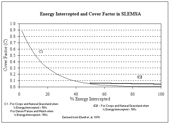
Figure 1. Relationship between energy intercepted and cover in SLEMSA.
In SLEMSA, the energy intercepted has been related to the cover factor (C). This cover factor varies exponentially between 0 and 1. Elwell prepared a set of percent cover/yield curves for different crops in Zimbabwe. He then went on to relate crop emergence date to energy interception values for different yields and different crops in the Zimbabwe Highveld. Therefore, the percent interception values presented cannot be used directly for conditions in Malawi where percent cover over time and rainfall energy over time may vary significantly. The current SLEMSA cover factor information must be modified to better suit Malawian conditions. Therefore with these types of relationships, both rainfall and cover are needed to develop a C factor.
Approach: The approach will be to develop a preliminary estimate for C using existing data, and to set up field trials to develop parameter estimation methods for C.
Development of the preliminary estimate for C will involve reviewing existing rainfall data from meteorological department, MEMP and LRCD. Crop Growth Relationships and Crop Cover Measurements data from Bvumbwe and Chitedze research stations. Using these a desktop estimate of C will be determined.
Percent cover versus time graphs exists for three years for the mixed cover conditions at the Bvumbwe Agricultural Station prepared for the Bvumbwe catchment study. This can provide a first approximation to percent cover versus. time. It might also be necessary to use the rain gage data from Bvumbwe to understand the protection provided by the canopy through time. Furthermore, it may be possible to determine canopy cover vs. time relationships for the MEMP plots in Kamundi and Chilindamadji as well using existing data sets.
With the percent cover and length of the growing season known, it is possible to adjust the C factor to account for regional differences in long term rainfall patterns. Therefore, preliminary estimates of C will be generated for different locations using the percent canopy cover vs. time relationships and differing rainfall patterns from these ten stations.
Then experimental plots with different crop mixtures will be set up at Bunda College of Agriculture and a recording rain gauge will be installed at the site.
All told, 10 different plots will be set up. These plots will be as follows:
Data to be collected will include rainfall, runoff, soil loss, crop emergency dates, plant spacing and height, and % crop cover and canopy using photos from a platform at 10-day periods through the growing season. At the end of the growing season root and plant mass and yield will be measured. Finally data analysis will be done in order to determine the effects of mixed crop cover as well as guidelines for establishing the cover factor.
4.0 Improving and refining methods for estimating the topographic factor in SLEMSA
Objective: The objective of this component is to revise the SLEMSA to include the RUSLE topographic factor which has been tested at slopes up to 84%, and to develop guidelines for selecting effective slope lengths for use in GIS.
Justification: The topographic factor is the means by which the SLEMSA model accounts for the difference in scale between the standard plot and actual hillslopes. Steeper and longer slopes will have higher topographic factors and higher soil loss.
The topographic factor currently in use in SLEMSA is only valid for slopes up to 20%. Furthermore, the slope length clearly varies in the field; as such it is not clear what effective slope length should be used in GIS application.
There is also an issue of the relationship with the slope length selected, the actual percent slope, and the resulting topographic factor, particularly for steep slopes (Figure 2). This is of particular concern when efforts are made to use a model such as SLEMSA to map relative soil erosion hazard at scales larger than the field. In addition Figure 2 shows that SLEMSA is not sensitive to slopes less than 20%. These shallow slopes represent extremely important agricultural lands, making this a serious limitation. The curves representing changing slope length appear to fall into several groups with similar slopes. The SLEMSA topographic factor becomes more sensitive to slope length on slopes steeper than 40%.
Slope length can easily be estimated in the field. However, it is not clear how the slope length factor should be applied in larger-scale spatial applications. However, the topographic submodel currently used in SLEMSA is limited to conditions with less than 120 m slope lengths and 20% slopes. As such it is not applicable to many parts of Malawi. On the other hand, the RUSLE topographic model allows for slopes as long as 300 m. Furthermore, the RUSLE slope relationship has been tested at up to 84% slopes.
Approach: Since the RUSLE topographic model has been tested at slopes up to 84%, it should be incorporated into SLEMSA. This will require some minor modification, so that the model is adjusted to the standard plot size in SLEMSA. Developing guidelines for estimating effective slope length will require both field and office work. We have speculated that it may be possible to estimate effective slope lengths for different covers in different physiographic regions. Therefore, it will be necessary to select physiographic regions that have distinct different cover types such as agriculture, savanna and woodlands. A statistical sampling of slope lengths would then serve as a basis for estimating an effective slope length based on physiographic region.
A simplifying strategy would be to use high-resolution topographic maps as a basis for estimating slope length. With such maps, it would be necessary to field verify slope lengths. It might also be necessary to do statistical sampling in a few areas with different characteristics, and then develop a regional estimate based on the proportion of each area with different characteristics.
We will identify five subwatersheds in each of the physiographic regions for each cover type and in each subwatershed, slope length, percent slope and stream order of drainage (i.e. 1,2,3) data will be collected at approximately 10 locations. Then regression equations for slope length (as a function of physiographic unit, % slope etc.) will be calculated having looked at indicators of central tendency for slope length as a function of physiographic unit and cover type (mean, median) and scatter (perhaps incorporate CV of slope length into SLEMSA).
5.0 Adjusting rainfall energy relationships for Malawi.
Objective: The objectives of this component are twofold: 1.) to identify areas of regionally different rainfall patterns, and 2.) to develop rainfall energy relationships that are valid for each of these different rainfall regions.
Problem Statement: The erosive energy relationships in SLEMSA are not appropriate for Malawi. The existing relationships have been based on the guti and non-guti rainfall relationships found in Zimbabwe, which do not occur in Malawi. Rainfall in Malawi varies greatly, and rainfall depths are up to twice the depths used to develop the rainfall energy relationships used in SLEMSA. As such, it is necessary to identify areas of different rainfall patterns in Malawi, and to develop regression equations for these areas relating rainfall depth and rainfall energy.
Justification: Rainfall energy (E in SLEMSA) is currently calculated based on the rainfall depth using relationships developed in Zimbabwe for non-guti areas (E = 18.846 P). Paris (1990) used this rainfall energy relationship for rainfall depths between 800 to 1200mm. Unfortunately, rainfall in parts of Malawi (Figure 4) exceeds twice the annual rainfall for the station with the highest rainfall used to produce the original non-guti regression relationship (958mm at Gokwe in Zimbabwe). In the one case for rainfall greater than 2000 mm for Zimbabwe (for Guti Rain from Stapleford Forest) the rainfall energy regression relationship seems to be a reasonable predictor of rainfall energy for higher rainfall depths for Guti areas of Zimbabwe. However, it is not clear what the rainfall depth/energy relationships are for non-Guti areas receiving greater than 958mm of rain, such as occurs in Malawi.
Rainfall energy remains a major question mark in the applicability of SLEMSA in Malawi because the rainfall depths in Malawi can be significantly higher than in Zimbabwe. Furthermore, the rainfall energy regression relationships developed in Zimbabwe may not be appropriate for Malawi.
Research is required to determine rainfall pattern distributions through time and space. This analysis could be achieved through analysis of existing decadal and monthly rainfall depth data. It is necessary to have an understanding of temporal variability so that the relationship between crop growth and rainfall energy can be better understood since the phase of greatest erosion hazard is the period when the crop is small and rainfall energy is high. It will also be important to identify zones where rainfall patterns and types are similar so that these rainfall energy/crop growth curves relationships can be grouped into a workable number.
Another important area of research would be the verification of the relationship between rainfall depth and rainfall energy in Malawi. This could be conducted with existing Malawi Environmental Monitoring Programme (MEMP) plot data, along with supplemental digitised rain gage charts from Meteorology to evaluate the return period for Malawian storms. To determine the rainfall depth/ rainfall energy relationships it will be necessary to use recording rain gage data that have both rainfall intensities (from which rainfall energy can be calculated), and rainfall depths. At present, there are four years of data from the four MEMP plots in different parts of the country. It will probably be necessary to supplement this with longer periods of record from 25 Meteorology Department rain gage stations with recording rain gage charts, though these are not currently digitised. These data should be digitised in phases as it becomes clear which types of data and locations would improve estimates.
Approach: Since the regional rainfall patterns will need to be identified for Malawi prior to looking at rainfall energy relationships, the first step will be to examine regional rainfall patterns. This will be done in coordination with the Meteorology Department of the Government of Malawi who has compiled information on rainfall patterns, and who has long term normal rainfall data.
The Meteorology Department is currently in the process of determining the rainfall intensities and durations for 25 rain guages over a period of 10 years. This data will allow researchers to determine the rainfall energy relationships for different regions of Malawi. Once temporal and spatial variation of rainfall is understood, this can be used to determine when the greatest period of erosion hazard occurs (i.e. when the crops are small and rainfall durations and intensities are high) for different regions of the country.
6.0 Further verify a monitoring and rapid assessment technique based on counting the number of broken ridges.
Objective: The objective of this research is to verify the monitoring and rapid assessment technique based on counting the number of broken ridges.
Problem Statement: A soil erosion monitoring and rapid assessment technique developed based on a single year of data may not work well in other years with different rainfall and crop growth characteristics. Therefore, there is a need to verify a soil erosion monitoring and rapid assessment technology with additional data before the technology is widely distributed.
Justification: The Malawi Environmental Monitoring Program developed a method to estimate the relative soil loss by counting the number of broken ridges in farmer’s fields. It was extended to include rapid appraisal methods based on interviews. This method was developed based on a single year of data analysis (1997-1998). A second year of broken ridge data were collected during the 1998-1999 growing season. The first year’s results were very promising. The data showed that the cummulative number of broken ridges was highly correlated with soil loss from field plots.
However, the method needs to be verified further before it can be widely applied. Since the MEMP will no longer be analyzing data collected on the broken ridges, the data would otherwise not be analyzed. Since soil erosion is the most important environmental problem in Malawi, there is a need to develop a simple means to monitor this erosion. Unfortunately, quantitative methods for soil erosion monitoring require expensive and complex equipment. Therefore, there is a need to develop a simple monitoring methodology.
Approach: The approach that will be followed will be similar to the approach used with the data collected in 1997-1998 (Mohamoud, 1998). The number of broken ridges will be compared with factors controlling erosion which include crop height, slope and rainfall intensity. Furthermore, the number of broken ridges will be compared with the sediment yield in the stream, and the soil loss from the small plots.
Since both the factors controlling erosion, soil loss and sediment yield were all well-correlated with number of broken ridges in 1997-1998, it will be important to verify that these relationships are consistent and predictable. Therefore, analysis of the 1998-1999 data on broken ridges will help to determine if the analysis of broken ridges provides a robust indicator of soil erosion under conditions in Malawi.
Attachment A: The SLEMSA Model
A. Introduction
The Soil Loss Estimation Model for Southern Africa (SLEMSA), is an attempt to get a quantitative estimate of soil loss from a simplified way of describing a relatively complex process. The SLEMSA, like all models, is a useful way to describe how a process works. To describe the details of the soil erosion process is typically not feasible or convenient. Furthermore, it should be recognized that soil erosion prediction is highly inexact. Errors up to an order of magnitude are not unusual. The SLEMSA is an attempt to describe the relationship between observed sediment loss and easily measured controlling factors.
Since SLEMSA is empirical, it cannot be used with confidence for conditions outside those for which it was developed. Therefore, since the model was developed for the highveld in Zimbabwe, it cannot be used with confidence in conditions markedly different from those in the highveld. While Paris (1990) has presented some modifications to the SLEMSA for Malawi, it is not clear whether these proposed modifications are based on experimental data. In fact, some of the changes appear to be a restating of information in the SLEMSA manual, and lumping for more simplified use. The following discussion is an attempt to describe the conditions in Malawi are similar to the conditions for which the SLEMSA was developed.
Soil erosion can occur as a result of wind, water or mass wasting, but most soil erosion prediction technology has focused on erosion by water. Since changes in land cover and practices often causes accelerated soil erosion, much of the prediction technology has addressed hillslope erosion processes rather than channel erosion processes. Furthermore, since prediction is highly inexact, the predictive methods are far more useful as a comparative tool for planning, than as a quantitative predictive tool.
On hillslopes, soil can be detatched by either raindrop impact or flowing water. As such, conditions which reduce the effects of either detatchment process reduces erosion. Therefore, a more dense plant canopy can reduce the impact of raindrops which reduces erosion. Likewise, water will flow faster on a steeper slope. The longer the slope, the more water will accumulate at the base of the slope. If grass or stubble is present where water is flowing, it tends to slow the water, reducing the potential for erosion.
While the erosion processses are easily-understood, being able to predict erosion based on them is more problematic. The data to begin to describe the processes, and measure the soil lost is only available at highly-insturmented research watersheds. The most widely-used predictive technology for soil erosion is the Universal Soil Loss Equation (USLE) which was based on years of soil erosion data from small plot studies in the southeastern United States. While the USLE does not describe the physics of the erosion processes, it accounts for the main factors thought to control erosion, which are:
In practice, a value is estimated for each of these factors from field data or a nomagraph, and the values are multiplied together to get an estimate of the annual erosion from a particular field. Since this is an empirical approach, it is strictly-speaking, a method applicable only for conditions in the southeastern United States for which the equation was developed. However, the model has been verified for other parts of the United States as well. Furthermore, it has been applied in other countries where the relationships have not been directly verified.
C. Development of the SLEMSA
Elwell (1980) developed the Soil Loss Estimation Model for Southern Africa (SLEMSA) in part because the conditions in Southern Africa are different from those in the United States. In particular, Elwell found that the EI30 index (maximum 30 minute intensity multiplied by maximum 30 minute rainfall depth) used to estimate rainfall erosivity in the USLE was not well correlated with soil losses for plot studies in Zimbabwe. Amphlett (1986) also found that the EI30 index was not well-correlated with soil loss for a small watershed in Malawi.
Elwell did however find that the total seasonal rainfall energy (i.e. sum of the energy imparted by all raindrops per unit area) was well-correlated with soil loss for small plots in Zimbabwe. Furthermore, he showed that this energy could be estimated from the rainfall depth for conditions in Southern Africa.
SLEMSA calculates soil loss (Z in tons/ha/yr) as follows:
![]()
Where:
The bare soil condition model predicts annual soil loss from a conventionally-tilled bare soil at 4.5 percent slopes 30m long. It is calculated from the following equation:
![]()
Where:
The soil erodibility ratings are based on an initial classification from texture on a scale of 1 to 10 from most erodible to least erodible soils. Additions or subtractions are made to the model for profile characteristics, tillage and management practices. Elwell does not know the origin of the indexing method, but says that it is thought to have been originally developed in the United States.
Elwell admits that the indexing system is very crude, and says that there is much work that could be done to improve estimates. For example, there has been no effort to relate erodibility directly to rainfall energy, such as could be done with a rainfall simulator.
Rainfall energy is given as the mean seasonal rainfall energy for the growing season. For SLEMSA, this has been calculated based on recording rain gage data from seven locations in Zimbabwe for periods of more than 20 years. These have also been supplemented with data from 22 sites with 10 years or less data, and intensity data for six different intensity classes.
Since rainfall energy can only be calculated with data from a recording rain gage, Elwell developed a regression relationship between rainfall depth (P) and rainfall energy (E) for the available stations. This is divided into orographic (guti) rainfall and non-orographic (non-guti) rainfall as follows:
E = 17.368 P (guti)
E = 18.846 P (non-guti)
Note: There are both linear and non-linear means to calculate rainfall energy. SLEMSA uses the relationship of Hudson (1965) which is:
![]() Where:
Where:
Energy is in J/m2/(mm of rainfall)
I = rainfall intensity (mm/hr)
For I > 25 mm/hr
For I < 25 mm/hr, energy = 0
This value is then multiplied by the rainfall depth for the storm (in mm) to get rainfall energy for each event in J/m2. All events for the year are summed to get the total rainfall energy for the year.
The value of C is the ratio of soil lost from a cropped plot to that lost from bare fallow land. The crop production submodel for SLEMSA is based on extensive yield data from the Zimbabwe highveld and lowveld. Essentially it assumes that the plant canopies intercept the rainfall, thus minimizing the effect of rainfall impact. The amount of energy intercepted depends on the planting date and the yield of the plant being considered. If the canopy is small when the most intense storms come, erosion rates are high. In contrast, if the canopy is large at the time of the most intense storms, the erosion rates are lower.
The energy interception value (i) is taken from a table listing the crop, the yield and the emergence date. Then depending on the type of crop, the following relationships are used:
C1 = e (-0.06i)
For crops and natural grassland when i < 50%
For dense pastures and mulch when i > 50%
C2 = (2.3-0.01I)/30
For crops and natural grassland when i > 50%
The value of X is the ratio of loss from a plot length (L) and slope percent (S) to the standard plot as used in the bare soil submodel (K). The developers of SLEMSA did not attempt to develop a topographic model directly, because adequate data were not available from the plot studies. Instead, they used the slope factor expression from the USLE adjusted to reflect a 4.5% slope 30m long plot, instead of the 22m long 9% slope plots used for the USLE. The relationship is as follows:
X = L 0.5 (0.76 + 0.53S + 0.076S2)/25.65
Another description for the topographic factor is also widely used in Malawi. This is as follows:
X = S(L) 0.5 /(10.742S + 8.038)
This second relationship may be flawed in that it does not result in a value of 1.0 for standard plot conditions (i.e. 30m long plot with 4.5% slope).
Attachment B – Sensitivity Index
The relative impact each factor may have in a particular soil loss model is critical, particularly if attempts are to be made to modify a model to suit Malawian conditions. Therefore it is recommended that sensitivity analysis be conducted before and after any new developments are made with any factor. Sensitivity analysis of a model such as SLEMSA or RUSLE is defined here as a method to determine the relative and absolute significance of model input parameters in affecting the model output. Implementing/performing/conducting a sensitivity analysis of the model input parameters aids in determining data collection and experimental needs and provides further insights into the physical processes.
Khonje et. al (1987) performed a crude sensitivity analysis for computing erosion hazard units (EHU) that was based on SLEMSA. In their analyses they investigated the effects of increasing and decreasing the subfactors by an arbitrary percentage and, in the case of the erodibility factor (F) by +/- 1. This method showed that the EHU computation is first sensitive to the crop factor and secondly to the erodibility factor (F factor) and the sensitivity to slope steepness and erosivity is weak. Mughogho (1998) performed an sensitivity analysis by increasing the three control variable (F,i,S) each by 15%. She found that the most sensitive parameter is the K factor since the 15% increase in the F factor caused a ~ 22% decrease in the resultant Z. The same analysis for the topographic ratio revealed a 15% increase in S resulted in a 15% increase in soil loss (Z). The last variable increased by 15%, the I value, resulted in only a small percent decrease in soil loss, ~4%. Mughogho used the following equation
Percent change = ![]()
where Iv is the varied variable or the variable with a 15% increase and Ib is the base value for that variable.
Where as the above methods provide insight into of the sensitivity of each parameter, the sensitivity index permits incorporation of a whole range of variations. It also permits calculation of the sensitivity over a large range rather than for simply one or two variations such as increasing each variable by 15% or increasing as well as decreasing the input values for a variable by an arbitrary +/-10%.
The sensitivity index is determined for each input parameter: energy interception, rainfall energy, soil erodibility, and the topographic factors of slope steepness and slope length. While one parameter is analysed, values for all other parameters are held constant. The sensitivity index represents a relative normalised change in output to a normalised change in input, allowing a valid means of comparing sensitivities for different input parameters that have different orders of magnitude.
The sensitivity index, SI, is given by
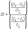
where I1 and I2 are the least and greatest values of input used, respectively, I12 is the average of I1 and I2, O1 and O2 are the associated outputs for the two input values, and O12 is the average of the two outputs.
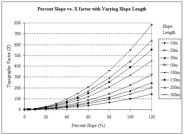 Figure 2. Percent slope combined with varying slope lengths can significantly impact the topographic factor and thus the overall results of SLEMSA for steep slopes (including many marginal cultivation areas) while have relatively no impact on the shallow slopes (prime farmland).