|
|
|
MEMP Homepage |
Final Report: GIS Technology Transfer: An Ecological ApproachJ. Ronald Eastman and James ToledanoThe Clark Labs for Cartographic Technology and Geographic Analysis
|
Acknowledgments
The development of the GIS technology transfer approach described in this report was funded by the United States Agency for International Development (USAID), Bureau for Africa, Office of Sustainable Development, and the Productive Sector Growth and Environment Division (AFR/SD/PSGE), under contract DHR5452-A-009083-12 and with subsequent assistance from the USAID/Malawi, to the SARSA (Systems Approach to Regional Income and Sustainable Resource Assistance), Clark University Cooperative Agreement. The authors wish to express their sincere thanks to Dan Dworkin for his assistance. Also, Kurt Rockeman for his enthusiastic support in-country and to Kent Burger, in-country Technical Advisor. Thanks are also extended to the Government of Malawi and their dedicated government staff, especially Ralph Kabwaza, Environmental Coordinator, Ministry of Research and Environmental Affairs.
Executive Summary
The GIS technology transfer approach described here addresses the issue of sustainable technology transfer in a development setting. It was prompted by a growing discontent within the development community, and the Bureau for Africa, USAID in particular, with the high cost and inconsistent results of GIS technology transfer projects in the area of environmental management. These poor results are due to the fact that most interventions primarily address the technological issues of the technology transfer process and not the more substantive issues that relate to the organizational and social issues of the process. In contrast to a traditional approach to technology transfer we have come to shape what we call the Ecological Approach -- one which is focused not on the technology per se, but rather, on the organization which adopts the technology, its role in society, and the manner in which the technology enhances or detracts from an organization's ability to function in a responsible, productive and sustainable fashion.
The Ecologiical Approach was developed in conjunction with MEMP, the Malawi Enviornmental Monitoring Program. MEMP is a collective effort between The University of Arizona and Clark University with the support of USAID/Malawi as part of the Agricultural Sector Assistance Program (ASAP). MEMP's goals are to strengthen the capacities of the Ministry of Research and Environmental Affairs (MOREA) and other line agencies to more effectively carry out the routine tasks related to environmental monitoring, and ultimately, to strengthen the efficient flow of information to effect environmental decision making. In order to meet these goals and to assimilate the data demands for environmental monitoring, new technologies and methodologies are being explored. The implementation of these new technologies, in particular GIS and Remote Sensing, is being conducted as a subactivity under MEMP by Clark University with six participating Malawi government agencies: Land Resources and Conservation Branch, Ministry of Agriculture; Department of Water; Department of Surveys; Department of Meteorology; Department of Fisheries; and MOREA. This report reflects only the research undertaken for this subactivity as it applies to the development of the Ecological Approach over a two year period from 1993 - 1995.
Geographic information technologies such as GIS, remote sensing, and global positioning systems are computer aided tools for the collection, storage and analysis of geographic phenomena. These tools, collectively, offer the potential for a higher degree of access to and management of geographic information and analysis. The use of these technologies can provide environmental decision makers with more timely and accurate information. The task of the technology transfer subactivity is to allow the participating agencies, in a coordinated fashion, to employ new geographic technologies to analyze data and provide environmental information in contribution to MEMP, and in the long-term, provide the important elements for a broader based national-level environmental information system.
It is from the Ecological Approach to technology transfer that we have developed a set of guidelines for implementing GIS. The result has been the development of a GIS implementation design strategy that includes five phases of implementation: 1) In-Country Orientation and Infrastructural Assessment; 2) Building Technology Awareness and Development of Core Teams; 3) Developing Management Support; 4) Applications, EIS and Human Resources Development; and 5) Transitional Phase. It is our contention that to be effective in fostering a sustainable and responsible technology, broad participation is required from stakeholders both within and outside of the organization in shaping the specific implementation process to be used. This participation focuses especially on the manner in which the organization transforms its procedures in order to accommodate the technology, the changes in infrastructure required, and the mechanisms that are put in place to allow it to continue to respond to change as though it were in a constant process of technology adoption. Finally, the transfer process must strive to fulfill the function that the technology is meant to serve in an efficient and socially-responsible manner.
The implementation of this component of MEMP has resulted in a variety of activities during the past two years, primarily in-country orientation and infrastructural assessment, training and development of core technical teams, technology awareness campaigns and developing of management support. A total of 18 GOM officers have now completed an intensive in-country GIS training course. To increase awareness about both the technology and its potential, a host of application projects have been completed in-country by the trainees primarily using local data and resources. These projects have demonstrated, for example, the use of GIS for managing forest resources, modeling landuse changes using satellite imagery, or monitoring drought. The first stages of this project culminated in a Decision Maker's Workshop which brought together all the participating agencies and senior level management and staff. This two day workshop was a forum for these agencies to articulate concerns and needs and to assist in the planning of subsequent follow-on activities.
The progress made during these initial stages of the project is strongly associated with the adoption of the Ecological Approach. In general, the approach has tried to remain flexible in order to address the diversity of issues pertaining to the socio-technical adoption process overall. This approach was also appropriate in accommodating the multi-agency approach adopted by MEMP in general. It can not be over emphasized that the transfer of innovations must be a planned, long-term process. So often this process is planned unilaterally without participation. This has become a prescription for failure. The one major advancement that the first stages of this project has come away with thus far is that the GOM, as well as the donors themselves, especially USAID, have embraced a process of technology transfer that is socio-technical in nature, and not with what has become traditionally associated with GIS technology transfer, the mere procurement of hardware and software. Both USAID and the GOM are committed to the continuation of the GIS technology transfer component under MEMP.
Glossary of Acronyms and Abbreviations
ADD: Agricultural Development Division
AIDS: Acquired Immune Deficiency Syndrome
ASAP: Agricultural Sector Assistance Program
AVHRR: Advanced Very High Resolution Radiometer
CCD: Cold Cloud Duration
DEM: Digital Elevation Model
DOF: Department of Forestry
DOM: Department of Meteorology
DOS: Department of Surveys
DOW: Department of Water
EIS: Environmental Information System
ENSO: El Niño / Southern Oscillation
EPA: Extension Planning Area
GEF: Global Environmental Fund
GIS: Geographic Information System
GOM: Government of Malawi
GPS: Global Positioning Systems
LRCB: Land Resources and Conservation Branch, formerly Land Husbandry
(Ministry of Agriculture)
LULC: Landuse / Landcover
MEMP: Malawi Environmental Monitoring Program
MET: Department of Meteorology
MOREA: Ministry of Research and Environmental Affairs
MSS: Multispectral Scanner
NDVI: Normalized Difference Vegetation Index
NEAP: National Environmental Action Plans
NOAA: National Oceanic and Atmospheric Administration
OSS: Observatoire du Sahara et du Sahel
RDP: Rural Development Project
SARSA: Systems Approach to Regional Income and Sustainable Resource Assistance
(Clark University)
SPOT: Systeme Pour l'Observation de la Terre
UN: United Nations
UNITAR: United Nations Institute for Training and Research
UNSO: United Nations Sudano-Sahelian Office
USAID: United States Agency for International Development
WRI: World Resources Institute
Introduction
Geographic information technologies, such as GIS, Remote Sensing, and Global Positioning Systems (GPS) are computer-assisted tools for the collection, storage, analysis and display of environmental phenomena. These tools, collectively, offer the potential for a higher degree of access to geographic information for the efficient and effective management and analysis of geographic phenomena while maintaining greater precision than previously-used methods. Ultimately, the use of these technologies can provide environmental decision makers with more timely and accurate information, and a more explicitly reasoned decision making process.
Although the use of these technologies shows significant promise for environmental management, it should be recognized that they have not met with expected success in development settings. GIS has been demonstrated and used successfully at the project level, but long-term sustainable implementation of this technology has not been forthcoming. In part this can be attributed to a number of technological issues such as effective training in the use of highly technical software, accessible user interfaces, stable computing environments, access to data networks, and the like. However, while these are important issues, to which significant resources are being directed, the more substantive problems related to sustainable technology transfer are associated with organizational and social issues.
The project described in this report addresses the issue of sustainable GIS technology transfer in a development setting. It was prompted by a growing discontent within the development community, and the Africa Bureau of USAID in particular, with the high cost and inconsistent results of GIS technology transfer projects in the area of environmental management. This project does not focus, however, on the technological issues of technology transfer (which are addressed in a previous USAID publication). Instead, the focus of the project is on the more substantive issues of technology transfer from the perspective of the organization which adopts the technology, its role in society, and the manner in which the technology enhances or detracts from its ability to function in a responsible, productive and sustainable fashion.
Such a perspective might appropriately be called an ecological approach since it is very specifically focused on the organization itself, and the role the technology plays in carrying out its functions. Such an approach is necessarily socio-technical in nature with significant emphasis being placed on understanding the character of decisions the organization is charged with making, the information products and analytical procedures needed to support these decisions, their frequency, accuracy and precision required, the infrastructure which is used to furnish these products, and the implications of the new technology for changing the quality, efficiency, and social acceptability of the process. It is the contention of this report that many of the failures that have been witnessed in GIS technology transfer relate to their focus on the technological issues rather than the ecological issues of technology use.
As a medium for developing and exploring this approach, it was decided to attach this project to an effort within the USAID Mission in Malawi in order to facilitate the development of an environmental monitoring system, as part of a larger agricultural assistance program. Although there was an understood risk that monitoring program development needs might detract from the central requirements of the project described here, it was felt that the discipline of an externally-defined case study would provide an important setting for exploring the issues concerned. Thus, many parts of this report talk specifically about the experiences gained in the Malawian context. However, it remained the overall objective of the project to explore the issues for sustainable geographic information technology transfer in Africa.
The Malawi Case Study
The Agricultural Sector Assistance Program (ASAP), with support from the United States Agency for International Development Malawi Mission, was designed to increase customary smallholder access to inputs, output markets, cash crop alternatives, and labor market information. ASAP was designed to support Government of Malawi (GOM) reform initiatives in these areas, as well as the implementation of discrete project activities. The initial focus of the ASAP policy agenda has been the liberalization of smallholder burley tobacco production on customary lands. More recent extensions extend this focus into other arenas.
Malawi is the world's second largest exporter of burley tobacco making it Malawi's premier cash crop. Burley accounts for 60% of Malawi's tobacco exports and 45% of total commodity exports. Consequently, it has become the best cash cropping opportunity for smallholders, having the highest return of any crop per hectare. Recent estimates show that just under 50% of the population is sustained from overall tobacco production.
With 27 percent of Malawi's arable land on steep slopes and with a population density exceeding 225 persons per square kilometer of cropped land in some parts of the country, soil erosion, especially in the Southern and Central Regions, is a serious and growing problem. This heavy erosion is primarily the result of increased cultivation and deforestation. Although flue-cured (fired) tobacco requires substantially more forest resources, burley must be dried in curing sheds requiring poles and thatched roofing. In either case, tobacco production has contributed to Malawi having one of the highest rates of deforestation in Africa.
Liberalization of burley tobacco production was intended to improve the income of rural smallholders, but may in fact further compound negative environmental trends. Recent reports have linked smallholder burley tobacco production with the displacement of established food crops such as maize and sorghum along with damaging crop rotation patterns, including over-cropping in order to "cash-in" on the lucrative market. Government policy for burley production seeks to gradually increase production commensurate with available resources, including extension programs, but it is currently estimated that in some areas up to 70% of production ignores established guidelines for tobacco production. This undermining can increase the difficulty in monitoring production, because, as is often the case, this form of production has its own distinct crop input, management and marketing strategies.
The need to monitor the impacts of burley tobacco production is self-evident, and as a result, the GOM has mandated the Ministry of Research and Environmental Affairs (Morea) to assess these impacts. MOREA is responsible for assisting ministries, departments and other organizations develop and coordinate policies and development initiatives that impact the environment. MOREA is expected to monitor all ongoing or proposed development activities in Malawi to determine whether they have, or may have, any significant environmental effects. Where negative environmental effects occur, or are anticipated, the Ministry is charged to undertake environmental impact analyses to identify the effects in more detail, and where possible, quantify and qualify them and thereafter make recommendations on the appropriate action to be taken to reduce the negative effects to an acceptable minimum.
USAID has a similar requirement to assess the environmental impacts of project activities. Thus, ASAP directly addressed the need to monitor environmental impacts due to changes in burley tobacco production policy. However, it was understood that MOREA was ill-equipped to monitor such impacts. In addition, it was clearly recognized that the problem would require inputs from a variety of similarly ill-equipped sectoral agencies. As a consequence, ASAP included the provision for assistance in the development by GOM of a multi-sectoral Malawi Environmental Monitoring Program (MEMP).
The Malawi Environmental Monitoring Program, as conceptualized under this assistance, would rely upon MOREA as the primary coordinating and reporting agency. However, strong reliance was to be placed on the cooperative contributions of agencies such as: Land Resources and Conservation Branch (LRCB), Ministry of Agriculture; Department of Water (DOW); Department of Surveys (DOS); Department of Forestry and National Parks and Wildlife (DF/NPW); and the Department of Meteorology (DOM). It was thus proposed that geographic information technologies, such as GIS and Remote Sensing, be used to assist in the integration of the vast amounts of data collected in fulfilling MEMP's coordination mandate and environmental decision making needs. However, while interest is heightened in Malawi for the use of these new technologies, the few activities that were already present in Malawi were quite isolated and uncoordinated from one another, and for the most part, ineffective. There was a need, therefore, for coordinated support for the sustainable transfer of GIS and Remote Sensing activities for environmental monitoring in the form of: training, hardware, software, technical support, and most importantly, in the institutionalization of the technology.
It was envisioned that the monitoring procedures developed for the MEMP would initially focus on the environmental impacts of burley tobacco production, but that in the process, a coordinated stream of information with wider implications would be supplied to decision makers throughout the government. It was within this context of facilitating more efficient and effective environmental decision making that the current project was attached to the MEMP capacity building effort.
Perspectives on Technology Transfer
Impressive strides have been made in the last two decades in the development and implementation of geographic technologies such as Remote Sensing and Geographic Information Systems. In concert with dramatic developments in computer technology, computer-assisted geographic information technologies have shown enormous potential in enhancing the manner in which we collect, manage, analyze and display environmental data for policy formulation and resource allocation. GIS and related technologies have become so widely adopted and successful in so many application areas that it is generally accepted by most in the industry that the technology is both extremely useful and cost effective, especially in the area of environmental decision making. It is not surprising, therefore, that expectations would be high for the role of GIS in enhancing environmental and natural resource management in developing countries. History, however, would seem to want to play itself over again.
During the early phase of GIS development, a seminal assessment of a group of implementation projects in Canada and the US observed that most had failed for reasons that has little to do with the technology itself. Rather, they faltered because they failed to address quite explicitly the needs of the organization they were designed for and the human aspects of technology implementation. However, as is amply demonstrated by Eason, this problem is not the exclusive domain of GIS. A commitment to information technologies is, more often than not, an implicit commitment to reorganize, and agencies rarely reinvent themselves without pain. If we look to the example of the recent history of GIS in the industrialized world, there is now a reasonably well-established (and growing) perspective on implementation strategies for GIS at the government level that properly views the process as one that is essentially ecological in nature. However, this perspective does not appear to be prevalent among development projects.
Perhaps because they are conceived in the context of limited duration projects, GIS implementation strategies in the development arena are typically focused less on long-term strategies for infrastructural reorganization, and more on short-term strategies for technology acquisition. As a consequence, the dramatic proliferation and success of GIS within industrialized nations has not been matched by the sustainable implementation of this technology in the developing world, especially in Africa. USAID and others in the donor community have been, for the most part, genuinely enthusiastic about the use of geographic information technologies for environmental management. However, this enthusiasm has been tempered by a growing awareness of these difficulties in moving beyond demonstrations to the development of sustainable implementations. The following four examples highlight some of the reasons for this growing concern.
The proposed projects, for the most part, were a vehicle for procuring hardware and software and not for the ultimate development of information for decision makers managing India's vast wastelands. They were developed with virtually no participation or involvement with intra-agency personnel, end-users, or local communities directly impacted by the wastelands. An alternative approach, which was initially met with much resistance, stressed a program that looked at specific problems on the ground and involved a broader participation with the ultimate beneficiaries and decision makers impacted within each case study. Subsequent proposals were later developed from this approach.
Upon arrival in 1992, the USAID evaluation team found two enthusiastic trainees but having virtually no support from the University, and more importantly, no support from their respective governmental agencies. The team's subsequent evaluation reported to USAID was that Oregon's "success story" consisted of no more than the transfer of hardware and software and the training of two government officers overseas. No attempt had been made to link the technology transfer program to the institutional needs and demands for the technology within the government agencies they resided in on a sustainable basis.
In 1992, a Swedish company was contracted through the GOM to facilitate the development of a national forest inventory of Malawi. The project involved the visual interpretation of Landsat remotely sensed imagery and subsequent digitization using Arc/Info GIS to facilitate the development of maps. The work was carried out almost entirely by the Swedish staff, however. Although efforts were undertaken to train two Department of Forestry personnel in the use of the Arc/Info software system and the methodologies employed for landuse/landcover change analysis using satellite imagery, the training was brief and the two government officers can not be considered functional users in any of the software used for the study. Moreover, less than two years after completion of the project the personnel trained had moved on to new posts leaving the agency still without an indigenous ability to carry out forest inventories using Remote Sensing and GIS.
In 1988 French government assistance led to the development of a Remote Sensing lab within the Land Resources and Conservation Branch of the Malawian Ministry of Agriculture. However, a specific configuration of French-manufactured hardware was installed despite the fact that there was no local technical support and extremely limited software for the analysis of remotely sensed imagery. It would be easy to identify this as the main problem with the project. However, ultimately, the more damaging factor was that the project was completed without a firmly established work mandate, no long-term fiscal plan, no plan for continuing software development, and no plan for continuing development of human resources. By 1993 the project was left with a single staff member, not a single piece of functioning equipment, and no plans for further activity.
These four cases help to explain the growing reluctance of USAID, and many others in the international community, in funding information technology projects. In an oft-cited article, Hastings and Clark correctly state that "African countries have unique challenges for the development and use of geographic information systems, resulting from their history, culture, politics, economics, needs and resources." Their solutions, however, are focused around the technology itself: those of improving software functionality, user interfaces, data integration, documentation and training aids. It is the argument here, however, that the problem lies not with the seed (to use an analogy), but rather with the ground in which the seed is sown. There is ample evidence that technology acquisition is all too often mistaken for technology implementation. It is simple; it is fast; it is glamorous; and it is (relatively) cheap. Vendors play a strong role in this process. All that is needed is the right hardware and the right software, or the right operating system. Donors also play a role. Technology acquisition is fundable and produces tangible evidence of work over the short-term life of the typical project; functional and sustainable implementation seldom is.
Solutions that primarily focus on or give too much importance to technology acquisition dominate the international development implementation strategies which have resulted in unsustainable GIS programs. The dominant approach typically relies upon a centralized strategy whose programs are primarily focused upon the development of a facility -- designed and installed by foreign experts. Functionally, the emphasis is often upon extensive data collection with little consideration of what the data will be used for. With regard to implementation, the reliance is characteristically on external resources: training programs abroad for a few promising candidates, and substantial purchases of donor country GIS-related hardware and software. Given limited project time frames, the implementation strategy typically calls for a 'big-bang' approach with the rapid creation of demonstration projects and pilot databases. Because it is often short-term in nature, directed toward accomplishing an initial application, this dominant approach does not allow for adequate local training or capacity building and often entails a significant amount of funding that has little long-term, or short-term, local contribution. More importantly, as the examples above serve to illustrate, these implementation schemes are centralized in nature with superimposed political or bureaucratic mandates for overseeing the implementation of these new technologies without significant participation from preexisting institutions.
The result of this technology acquisition implementation strategy is most often associated with the development of centralized GIS resource centers that have as a mandate to develop, coordinate, and maintain activities related to geographic information technologies. There is, however, little in the way of developing a self-reliant indigenous GIS infrastructure. More importantly, perhaps, little has been done to supply the relevant environmental decision makers with efficient and effective information on resources and environmental processes. In the end, these schemes only hinder the future use and implementation of GIS by barring participation of end-users and benefactors in the design process. This technology-driven approach has characterized the implementation of Environmental Information Systems (EIS) in general and GIS technology specifically in Africa.
An Ecological Approach to GIS Implementation
An Alternative Strategy
As was outlined in the previous section, the dominant strategy for GIS technology transfer in the developing world might be described as a Technological Approach -- one which is focused on the acquisition of technology, often in showcase organizational structures superimposed on existing governmental frameworks, with little regard for the development of indigenous capabilities and the long term resources required to maintain its activity. These centralized, top-down implementations rely heavily on continued technical and financial assistance from the donor community -- a fragile resource given the limited time frame of most donor projects.
As an alternative strategy, the technology transfer program developed for Malawi, on the one hand, embraces a focus on existing governmental structures and their socio-technical evolution, and on the other, takes recognition of the limitations imposed by a context driven by donor funding and set within a framework of developing national government structures. In essence, it tries to balance the need for a rapid initial development to fit the limited time frame of typical project designs (e.g., 3-5 years) with the need to prepare the ground for the seed of GIS to take root, by addressing the nature of the organization itself, its role in society, and the role the technology can play in carrying out its functions. As indicated at the outset, such an approach is necessarily socio-technical in nature with significant emphasis being placed on understanding the character of decisions the organization is charged with making, the information products and analytical procedures needed to support these decisions, their frequency, accuracy and precision required, the infrastructure which is used to furnish these products, and the implications of the new technology for changing the quality, efficiency, and social acceptability of the process. We call this an Ecological Approach in the sense that is focuses on the manner in which technology affects the relationship between an organization and the governmental environment in which it must function.
In contrast to the dominant implementation strategy currently employed in the developing world, the strategy advocated here is not oriented to the centralized acquisition of technology through the development of a new facility superimposed upon existing government structures. Rather, it is expressly oriented to the incorporation of new geographic information technologies within existing agencies. As such, it can be characterized as a decentralized, bottom-up, problem-oriented approach that looks at the functional role of the organization and how GIS can be used to enhance that role.
Clearly, typical project time frames do not permit the full evolution of such an approach to take place. However, unlike the dominant approach, this need for an initial rapid implementation does not imply a "big bang" short-term approach. Rather, the intention is to establish a fertile ground in which a rapidly germinated seed can grow on its own. It is thus oriented to a long-term evolutionary implementation, relying heavily on the internal resources of the organization for continuing nourishment. Thus, it is necessarily participatory in nature rather than being imposed by external agencies using foreign resources. Table 1 contrasts this alternative approach with that which dominates current strategies.
Table 1: GIS Implementation Strategies
|
Technological Approach |
Ecological Approach |
|
Centralized |
Decentralized |
|
Top-Down |
Bottom-Up |
|
Technology Focus |
Problem Focus |
|
Imposed |
Participatory |
|
"Big-Bang" |
Evolutionary |
|
Short-Term |
Long-Term |
This is an ambitious undertaking, and one that is clearly experimental in the context of this paper. In part its origins derive from a long history of experiences in technology implementation in the developed world focused by a wide range of personal experiences in various aspects of GIS technology transfer for the UN and USAID. However, it also derives its origins from a trend in the development field that attempts to counter traditional development approaches that tends to wed development to economic determinants and goals, executed through centralized authorities with little or no ties to the beneficiaries of development projects and programs.
In reaction to these past approaches, a participatory approach has been adopted as an alternative strategy in development schemes in recent years. This approach is a people-centered development approach that advocates a process of development and not an orchestrated blue-print. This process, implying long-term involvement and commitment, includes such methodologies as institution building, enabling capabilities and individual end-user participation. Participatory methodologies are centered around a learning process approach, the heart of which is the empowerment and participation of those whom development projects are intended to address. The learning process seeks commitments to building local problem-solving capacities in order for people and communities to sustainably participate in their own development process.
By engaging in this learning process approach, we alter the current notion that change and development are good if the measured results are rapid and readily quantifiable. The learning process adopts a phased development approach rather than an initial encompassing comprehensive plan. Instead, it focuses on creating enabling settings and the development of organizations within local institutional frameworks. The challenge is to integrate methods of trial and error, action-taking, knowledge-creation, and institution-building into a coherent and sustained development or learning process. The process and settings internalize people and the environment to incorporate human goals into the decision making framework. "The dominant logic of this new paradigm is that of a balanced human ecology, its dominant resources are the inexhaustible resources of information and creative initiative, and its dominant goal is human growth defined in terms of greater realization of human potentials." It is "the logic of place, people, and resources bound into locally, self-sustaining human ecological systems."
This is Korten's philosophy for change, an approach to development, one that puts forth new thoughts, beliefs, and basic ideas for viewing other realities and addressing fundamental development problems, such as, poverty, environmental deterioration, and empowerment. It counters dominant development theory that is production-centered, that externalize people and seeks objectivity, and instead, advocates methodologies that tend to internalize people and the environment by not favoring value-free scientific approaches.
In the context of this project, the GIS implementation strategy proposed here is both ecologically-oriented and participatory in nature. It seeks to empower existing agencies and the personnel that make them function. It focuses on the process of technology implementation by concentrating on a planned, phased and facilitated evolution of internal capabilities. As a consequence, it is naturally oriented to the function of the organization, the physical and human resources it can muster, and the manner in which these resources can be shaped and strengthened to foster the evolution that is envisioned.
The Ecological Approach: A Strategy for Technology Transfer
Given the above, we outline here a strategy for technology transfer that has formed the basis for the case study undertaken in Malawi. The key issues that are addressed in this strategy are sustainability and feasibility -- sustainable in the sense that the technology introduced becomes a natural and supportable feature of the functioning organization, and feasible in that it can be implemented within the expected constraints of a developing nation context and initiation through donor assistance within the limited time frame of typical donor projects (3-5 years). It is argued here that to be sustainable, the technology transfer project must be:
The project should use, as a continual reference and benchmark against which to gauge progress, the responsibility of the organization to society, and the role of the technology in facilitating the effective fulfillment of that responsibility. In doing so, the project will need to articulate the decisions and/or products the organization is responsible for, the information products needed to fulfill that role, the frequency with which they are required, and the data and analytical procedures needed to produce them. It will also need to articulate the resources and organizational structures required to fulfill this role.
This focus is so fundamental that it gives its name to the entire approach. Only when the technology meets stated organizational goals and needs will implementation move towards sustainability. It is also important to stress that this focus is not a one-time static evaluation. Rather, it is a continual process of assessment that serves to allow the organization to adapt to constantly changing needs, resources and technologies.
As a result of the ecological focus, it must be clear that there is a well articulated need for the technology being introduced. It must be clear that the technology provides either a more cost-effective means of producing existing products or decisions, or that it offers significant enhancements in their quality or character, or that it affords the possibility of new products or decisions that result in an enhancement of the organization's societal role. In the case of GIS and related technologies, likely candidates include the introduction of new data acquisition technologies (such as GPS, Softcopy Photogrammetry, and Remote Sensing), product development technologies (such as Desktop Mapping and Pre-Press technologies), and decision support and analysis technologies (such as GIS). However, in each case, a well-articulated end-user group needs to be identified and consulted for any adequate statement of demand.
Participation is fundamental to the strategy articulated here. In a context of public service, each person in the organization under study and the constituency it serves are stakeholders. It is logical that stakeholders are more likely to embrace and facilitate a change if they feel that the technology adoption proposed is consistent with their needs and represents an enhancement of the capabilities of that organization. Similarly, it is reasonable to expect that the technology transfer project will most likely meet a demand-driven mandate if the stakeholders concerned are directly involved in the articulation of the adoption process and the character of the technology to be introduced. In the context of GIS and related technologies, likely stakeholder groups include end-users of the products and decisions the organization is charged with, management, and production personnel including technicians and research analysts.
As a corollary to the above, it has become clear from recent evaluations of the introduction of information technologies that the participatory procedures advocated must include a focus not only on the products and procedures used, but also the people involved. Technological change has strong implications for job security, appropriateness of educational background, changes of job description, and disruptive training and implementation procedures. Stakeholders truly hold a stake that in many cases lies at the very heart of their professional and personal lives. Technology implementation is difficult enough without fighting enemies from within. Members of the organization need to clearly understand the reasons why the technology is being proposed, the benefits that will accrue and the personal implications that result. Particular care needs to be addressed to the manner in which the transition in technology is to be achieved and ways in which stakeholders can be involved without being left behind.
This is a commonly understood perspective in the field of international development, and yet it is all too frequently violated in the interests of positioning technologies within the international community. There is a natural and understandable tendency on the part of national development agencies to push the best technologies their countries can offer. There is also a natural tendency on the part of host country institutions to want to be on the cutting edge by implementing state of the art technologies. This orientation is further fueled by vendors who have a strong economic incentive to promote their wares regardless of ultimate appropriateness. However, in a context in which one envisions an organization to go through a process of evolution in its needs and capabilities, it is unlikely that a single technological configuration will be appropriate through the lifetime of the implementation process. Appropriate technologies are those that address the needs of the organization at the specific stage of their evolutionary implementation, for which adequate financial and human resources can be addressed without unbalancing the resources that must be directed to other activities.
As a final requirement for sustainability, the project must be strongly focused on self reliance. Given the limited time frame in which a donor-funded implementation project can be undertaken, it is clear that the organization in question is going to be left with the major part of the process on its own. Thus major efforts must be focused on the development of self reliance, both in terms of human and financial resources. By the end of donor funding, firm procedures should be in place for the provision of a continuing stream of trained staff and a long term financial plan.
These are basic conditions that are necessary for sustainable implementation. However, to be feasible in the context of a donor-funded project in a developing nation, the project will further need to be:
It is perhaps unfortunate that we use the term technology to refer to GIS and related environmental information technologies since it too easily conveys the notion of some thing that can be acquired. While there certainly are physical components to these technologies (such as hardware and software), the mere possession of a GIS does not imply that one can use a GIS, nor that one can produce useful products. There is a process of learning and adaptation that is, to many, surprisingly long. GIS is foremost a way of thinking, and for an individual, the route to full productivity can take years. For an organization, however, the process is exaggerated, with the many adjustments required for full functionality taking perhaps a decade or two rather than years. This almost certainly dictates that the route to full implementation lies beyond the scope of the typical donor-funded project. Thus the focus needs to be very clearly steered away from the concept of acquisition to the process of implementation.
Given that implementation is best characterized as a long-term process, the project will need to articulate a phased approach with clear objectives and a funding strategy articulated with each phase. To accept that the process is a long-term one with only the final objectives being specified, and no sense of the stages that lie between, is almost a certain formula for failure. At the outset, probably the only phases that can be clearly articulated are those for which donor funding will be used. However, at the very least, this specification should include a transitional phase in which the organization takes over full responsibility for the conceptualization and administration of the project, with only backup technical assistance being provided by the donor technology transfer team.
Phased Evolution: GIS Implementation Design Strategy
The above are guidelines to be used for developing a sustainable GIS implementation design. Together, these guidelines address the critical areas in the design process, i.e., the technological, organizational and social issues. In general, there are three phases to the design process.
Phase One: In-Country Orientation and Technology Awareness
The first phase of the technology transfer process is information gathering and technology awareness. Its objectives are three-fold. First, to gather information on institutional, cultural, technical and bureaucratic issues in order to assess the immediate needs and potential barriers at the organizational level to do environmental monitoring, as well as, to assess the degree to which technologies already play a role in decision making processes. The second objective is to begin an awareness campaign at the decision making level regarding the potential of the technology for environmental management. Together, a highly trained technical staff and the decision makers should be involved from the very beginning to fulfill organizational mandates, and hopefully, in the end, be part of a future long-term technology implementation design team. The third objective is to identify potential candidates for technology training activities who will ultimately become the foundation of any future technical capability.
Phase Two: Geographic Technology Training and Application Development
This phase will develop local capacities within organizations while demonstrating the use of the technology for solving relevant problems. This phase will move into more elaborate training with particular emphasis on developing applications. Through broader organizational participation and consultation with decision makers, quick demonstration applications, or pilot projects, should be developed that address specific problems within respective participating organizations. These demonstration projects will facilitate: (1) a quick and useful in-house demonstration with limited data collection; (2) further development of an in-house GIS capability; and (3) a broader technology awareness campaign within and outside the participating agencies. There should also be an emphasis during the training process on the organizational issues surrounding GIS technology transfer. These issues should emphasize GIS as a decision support tool rather than as a technical black box.
Phase Three: Long-Term System Design and Development of Sustainable Implementation Strategies
The final phase of the project has two objectives: (1) to evaluate the progress of the preliminary implementation process based on its participatory design approach at the organizational level; and more importantly (2) to the extent possible, elicit from a broader end-user group their concerns and perspectives for long-term technology implementation. In essence, this last step will lay the foundation for a more formalized system design process and the eventual development of National Environmental Information Systems.
Phased Evolution: The Malawi Case Study Example
Although specific designs will vary with the specifics of the context involved, the phases that were initially envisioned for the Malawi case study are perhaps typical of those that might be articulated for many such projects. In this particular case it was envisioned that the first stage of available funding would allow, after identification of host country institutions and acquisition of funding, two years of in-country technology transfer activities. It was also understood, however, that although not certain, there were likely to be funding mechanisms that might allow the activity to continue for perhaps 2-3 years further. More specific details about each of these phases are provided in the next section. However, a brief outline of the phases envisioned for this funding horizon provide a good illustration of a phased evolution design using an ecological approach when adapted to a specific case example in Malawi.
Phase One: In-Country Orientation and Infrastructural Assessment
This is an inevitable phase in which logistical details are worked out. However, a key element is an initial assessment of the government infrastructure in which the project will be developed. In the context of the Malawi case study, where a decentralized system involving six agencies was envisioned, this promised to be an extensive process. However, with this many agencies involved, an equal concern was a mapping of the donor project context since each of these agencies was or could potentially be involved in similar projects that might articulate divergent or conflicting goals. Also of concern was an assessment of the educational system, the state of professional development in GIS and environmental management, and an identification of cultural and political impediments to the implementation process.
Phase Two: Building Technology Awareness and the Development of Core Teams
The second stage was envisioned as one in which technology awareness would be rapidly built through the development of a core team within each of the participating agencies. From the context of the MEMP, this team was envisioned as the main technical team that would support agency participation in this multi-agency activity. However, from the context of the long-term capacity building objective of the MEMP activity, and the specific needs of this project, the core team was envisioned as the main vehicle by which awareness of GIS and related technologies would be spread within each agency. Effort was therefore concentrated on the development of a research capability using GIS through an intensive program of in-country trainings. Efforts were also undertaken to facilitate the development of a professional association and links with international professional arenas such as AFRICAGIS. Besides participation in specific MEMP project activities, these core teams were envisioned as playing a major role in the next project phase.
Phase Three: Developing Management Support
From interviews in Phase One, it was determined that the most effective means of developing management support would be through the development of pilot projects that could effectively demonstrate the potential application of GIS and related technologies to specific agency needs and the potential of agency personnel to carry out the work. The culmination of this process was envisioned as a Decision Maker's Workshop in which, along with general overviews of the technology, agency personnel drawn from the core teams would present their pilot projects to upper level decision makers of all the agencies in the MEMP program. From this it was intended that the groundwork would be laid for the institutionalization of selected key applications along with a favorable orientation to the development of an in-house implementation initiative at a later stage. As a part of this preparation, it was planned that senior-level decision makers would also be apprised of the general character of the technology transfer and institutional implementation process.
Phase Four: Applications and Human Resources Development
As a follow-on to the development of management support, it was envisioned that the project would move to a phase of developing specific key applications within each agency as an in-road to institutionalizing GIS and related technologies. However, it was envisioned that major attention would also need to be focused on the development of a continuing flow of trained personnel: in part through continued in-country trainings, but increasingly through the development of an in-country university-based training and education capability.
Phase Five: Transitional Phase
The final phase that was envisioned for the anticipated five years of donor-funded activity is unquestionably the most ambitious. It concerns the transfer part of technology transfer, not as a packaged donation of goods, but as the handing over of a process of implementation. Because of the individual nature of each agency involved, details of this phase were not sketched out at the time of project design, nor have they been as yet. However, it is anticipated that this phase will involve the internal establishment of a development team, a formal needs assessment, establishment of an initial project design, and the development of short- and medium-range fiscal and human resource development plans. In the specific context of the Malawi case study, however, it is also envisioned that this stage will see the articulation of a national Environmental Information System (EIS) as a distributed set of data provision and analysis activities in support of a wide range of environmental initiatives.
Post-Transitional Implementation
To have the final phase of donor-funded activity be called the Transitional Phase underscores the emphasis on self-reliance in the Ecological Approach. By the end of this stage, it is envisioned that each agency will in fact be productive with GIS and related technologies to a certain degree. Primarily this will be of the nature of the provision of a limited number of specific information products along with the general capability to support the use of these technologies as part of specific research initiatives. However, for each of the agencies involved, it is likely that the process of articulating the potential applications of these technologies to the functional operations of that agency will uncover a much more far-reaching role for which a long-term implementation strategy will be required. Activities during post-transitional stages will likely include the development of standardized information products as part of a national mapping program (a key element of an EIS), the establishment of a formal management subsystem, with companion subsystems for continuing data provision and information product use, and a continuous process of self-analysis and respecification of technological needs and implementation strategies.
Project Evaluation
As a final consideration, the problem arises as to how to evaluate a project of the nature described in this document, when the avowed intention is to hand over the process at an intermediate stage. Clearly it would be easy to sidestep the issue in this context. However, the eight characteristics of the Ecological Approach sketched out above, and in conjunction with the five phase objectives as well, can also serve as criteria for the evaluation of the project at the time of the transitional phase. Evaluation would thus include an assessment of the degree to which the project has identified the issues targeted and established a process in which these criteria and objectives are being addressed:
In the next section, the specifics of the Malawi case study design will be enumerated, followed by an evaluation using these criteria as the structure not only for an assessment of progress made in the specific case of Malawi, but also of the potential of the Ecological Approach to address the problem of sustainable technology transfer in the developing world.
Malawi Case Study Project Implementation
Introduction
Given the general character of the Ecological Approach that has been outlined in this report, we now turn to the specific details of the Malawi case study.
As was mentioned in an earlier section, the Malawi case study was conceptualized as a capacity-building project in support of the Government of Malawi's Malawi Environmental Monitoring Program, under assistance from the USAID Agricultural Sector Assistance Program (ASAP). As designed, the MEMP was intended to function as a distributed multi-sectoral system under the coordination of the Ministry of Research and Environmental Affairs (MOREA). Participating agencies were initially envisioned to include: Land Resources and Conservation Branch; Ministry of Agriculture; Department of Water; Department of Surveys; Department of Forestry and National Parks and Wildlife; and the Department of Meteorology. Although the overall USAID assistance to GOM for the MEMP included a broad range of assistance inputs to facilitate the monitoring of environmental effects related to policy liberalization in the area of burley tobacco production, the specific component that forms the focus of this case study was the development of a supporting capability in environmental reporting and analysis using GIS, Remote Sensing, and related environmental technologies. Because of this focus, the Department of Fisheries was added as a seventh agency as a result of a specific request relayed by the World Bank.
It is important to distinguish here between the MEMP development project and its initial mandate to monitor the impacts of burley production versus the more specific GIS implementation project described here. The overall infrastructure of the MEMP was developed by GOM with assistance from the USAID Mission in Malawi. Logistical support for that activity, and specific support for the burley monitoring component was provided, through USAID assistance, by the University of Arizona, in close cooperation with the Clark University team who was primarily responsible for the component described here. Given this breakdown of responsibilities, the GIS implementation project was not directly concerned with the nature of the MEMP infrastructure and any specific activities related to the burley monitoring. However, there was a close collaboration between USAID/Malawi and the Clark and Arizona teams, and priority was given to accommodating any specific needs that arose in the context of the evolving MEMP development. In addition, while the specific mandates of the various groups involved were clear, all groups worked in close cooperation. Thus, while the GIS implementation activities addressed by this project were derived from a broader capacity building mandate, many of the activities undertaken incorporated specific details related to immediate needs arising from the burley monitoring program.
As an overall project objective, the GIS implementation project sought to establish a sustainable capability in the use of GIS and related environmental information technologies in support of MEMP environmental monitoring and analysis activities. However, because each of these agencies was brought into the MEMP on the basis of their existing roles in the collection and analysis of environmental data, interest in GIS and related environmental information technologies often went beyond the more specific needs of the MEMP.
As was outlined earlier, the GIS implementation project was set out in five phases. These are covered in more detail here. However, it should be noted that this project is on-going, and that work has not yet begun on phases four and five. Thus the report and evaluation on this specific case study must be viewed as an interim report.
Phase One: In-Country Orientation and Infrastructural Assessment
The first phase of the project began in November of 1993 as an in-country orientation and infrastructural assessment. The intention was to establish a relationship with host institutions and undertake an initial assessment of indigenous capabilities, broad infrastructural characteristics, and gain an orientation to the educational, cultural and political contexts in which the project would be set.
MEMP Structure
The first logical step was to establish the structure in which the project would be developed. Briefly, it was established that the Ministry of Research and Environmental Affairs (MOREA) would act as the overall coordinating and reporting agency for the MEMP. As such, it would logically be responsible to the National Committee on the Environment (NCE) -- a senior government-level environmental policy development body. However, while MOREA might be charged with reporting on the state of the environment and specific research questions, it was envisioned in the MEMP development plan that it would do so based on data collected and analyzed by the participating line agencies.
MEMP Participating Agencies and GIS Needs
A critical step in the implementation project was to identify the nature and direction of the demand for this new technology. Throughout the process a dialogue was opened with each participating agency to facilitate the two-way communication and articulation of needs. While each agency had needs that were specific to the activity of that organization, and which could be articulated in the context of existing operations, many were unfamiliar with GIS and the kinds of analytical capabilities that would be needed to support the monitoring activity envisioned for the MEMP. As a consequence, the Clark/Arizona team identified an additional set of analytical needs that were deemed to be essential to support MEMP:
- Change Analysis, in support of monitoring activities. Since many of the data sets were envisioned to be quantitative in nature, procedures for the distinction between true change and natural variability was a strongly needed component. Similarly, analyses with strong statistical foundations were required.
- Time Series Analysis, in support of monitoring activities. Emphasis would be placed on the extraction and identification of significant trends.
- Multi-Criteria / Multi-Objective Decision Analysis to enhance resource allocation strategies associated with mitigation procedures.
- Error Analysis and Risk Assessment. In all contexts there is an important relationship between data quality and decision risk. In developing nations, however, where data resources are limited, this is especially important. Lower quality data can be effective in decision making contexts if error levels can be quantified and propagated in analytical procedures. Emphasis was thus needed on simple and cost-effective post-mapping assessment procedures, propagation techniques and risk assessment procedures.
Given these more general needs, agency-specific requirements identified during this initial stage included the following considerations:
MOREA
MOREA constituted a strong logical demand point for GIS given that it has been identified as the agency responsible for coordinating MEMP activities and summarizing and reporting on the results of data products and analyses conducted by the line agencies. However, the agency has been slow to develop its scientific staff, and as a consequence, needs were identified largely by the Clark/Arizona team in conjunction with senior MOREA administrative staff. It is impossible, therefore, to view these demand perspectives as unbiased. However, in addition to general competency with the use of GIS and related technologies (GPS and Remote Sensing) specific capabilities, it was considered that MOREA staff would need to have particularly strong proficiency with analytical procedures, particularly in the context of the statistical analysis of spatial phenomena. To some extent, it was envisioned that these needs would be accommodated in training activities associated with the more general list of analytical needs articulated above. However, it was also envisioned that more specific training would need to be developed in areas relating to experimental design and spatial statistics.
The GOM Line Agencies
As part of their participation in the MEMP burley monitoring project, each of the identified line agencies was mandated to develop a small MEMP unit consisting of appropriate scientific and technical staff. Each unit would participate in regular MEMP organizational meetings and direct agency activities in response to stated needs. As such, their GIS needs would thus correspond with those identified within the general MOREA context, with the addition of specific elements to suit that agency's role. In addition, however, each agency had interests in GIS that were internal to that organization. Although the primary focus and responsibility was to those needs associated with MEMP activities, individual agency interests often formed a useful focus for training activities. The following briefly outlines some of these agency-specific needs. A more specific outline of agency needs (without reference to MEMP), developed as a result of a special Decision Makers Workshop (to be discussed further in a later section) can be found in Appendix IX.
Department of Forestry
In the context of the burley monitoring project, DOF was charged with monitoring changes in forest resources related to wood use in the burley curing process. As a consequence, emphasis was placed on the use of high resolution satellite imagery and GIS as a low-cost forest mapping technology. DOF also expressed an interest in the ability to use GIS to help map plantation resources based on surveyors records. Also included were procedures for forest change mapping including change related to both clear-cut and thinning procedures.
Land Resources and Conservation Branch, Ministry of Agriculture
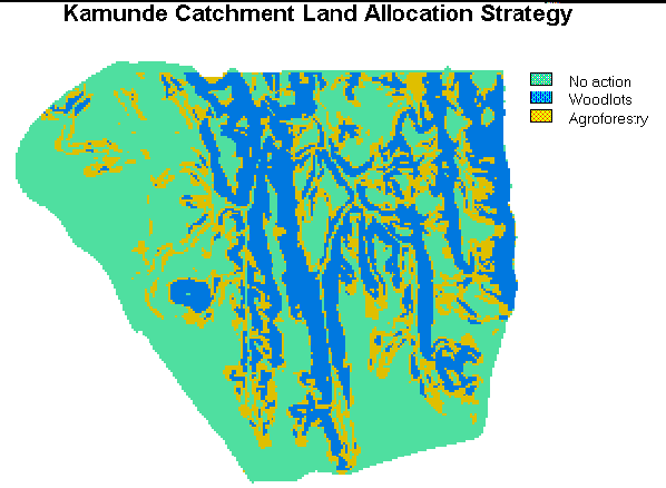
LRCB is the primary agency responsible for landuse mapping in Malawi. In addition, the burley mapping project required that landuse maps be produced for each of the watersheds being studied. As a consequence, emphasis was placed in teaching the procedures for supervised and unsupervised landuse / landcover assessment using high resolution satellite imagery. Special attention was given to ground truthing procedures using GPS as well as post-classification accuracy assessment. Assessment of the ability to detect burley tobacco and distinguish it from other crops was also conducted.
Department of Meteorology
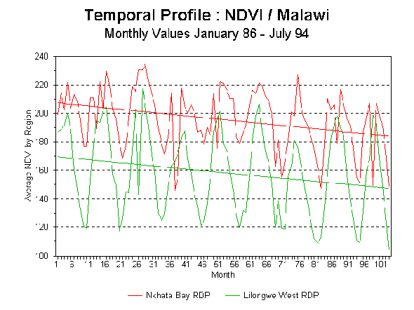
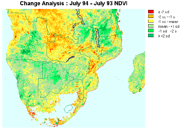
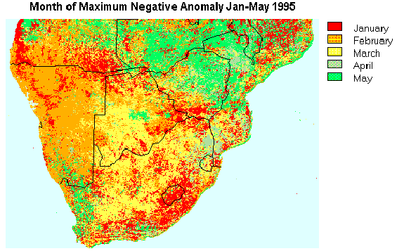
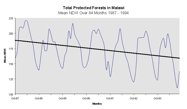
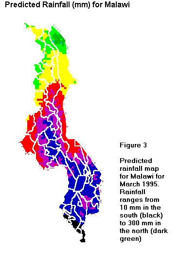
For the burley monitoring project, MET was primarily responsible for providing rainfall statistics for each of the watersheds being studied. Emphasis was therefore placed on the interpolation of point data to create precipitation surfaces. This was extended in accordance with more general departmental needs to include the use of Cold Cloud Duration (CCD) data from the Meteosat satellite to act as a predictive component in surface interpolation. Another area of significant interest to MET was the ability to monitor droughts. Thus specific emphasis was placed on Change and Time Series Analysis techniques associated with the use of NDVI (Normalized Difference Vegetation Index) imagery from the NOAA satellites for the monitoring of El Niño / Southern Oscillation (ENSO) events. This proved to be timely as an ENSO warm event (associated with drought in Southern Africa) occurred during the 1994/95 summer season.
Surveys Department
In most contexts it was assumed that Surveys would be the provider of topographic data. Thus emphasis was placed on the development of digital elevation models (DEM's) and the registration of map data to the national geodetic framework. Topics covered included generation of DEM's from digitized contours, generation of DEM's from aerial photographs using PC-based analytical plotter software and image correlation techniques, polynomial-based rubber-sheet resampling techniques, datum adjustment, forward and backward projection, and georeferencing system design. As part of this work, a national level minimum error georeferencing system was designed and subjected to error analysis.
Department of Water
DOW was responsible for the siting of stream gauging equipment and the assessment of water quality information. Identified GIS needs included groundwater mapping and non-point source pollution assessment. Micro-catchment analysis was also covered as part of the process of siting runoff pits. The use of CCD data to estimate rainfall was also of significant interest to this group because of the need to estimate direct recharge into Lake Malawi as an input to power facilities on the Shire River (at present, there are no rain gauges on the lake).
Department of Fisheries
As indicated earlier, the Department of Fisheries was not originally envisioned as a participant in the MEMP but was later brought into the program as a result of interest by both the Department and the GOM given the importance the Department plays in Malawi's environment. The Department is primarily responsible for managing the largest natural resource, Lake Malawi. Their main activity is the management of fish habitat and stock and fishing rights. The Department is barely maintaining an information base on the lake and is keenly interested in using automated procedures to facilitate this process.
The Donor Community Context
Regardless of the needs of the GOM for information technology, government agencies and departments are often responding to international pressures, either in the form of compliance to international regulations for which they have become signatories, or when evaluating impacts of projects funded by outside sources. The GOM's need to respond to these demands are critical and constitute another level of articulation of needs that need to be addressed, and for which geographic information technologies can offer significant assistance.
As an overall assessment, it would be fair to say that there is an enormous interest on the part of donor agencies in issues of environmental management. This translates into equally strong pressure to adopt project components that meet these interests. As an example, one only has to consider the political context established by Agenda'21, the enormous economic weight of the Global Environmental Fund (GEF) that was established as a result, pressures associated with the World Bank's efforts to establish National Environmental Action Plans (NEAP's) and consequent investment plans whereby intellectual and human resources are increasingly steered into environmental projects. There is seemingly no lack of funding opportunities for environmental projects. In this climate, technology implementation projects are extremely attractive. They provide concrete evidence of efforts to deal with perplexing issues. However, this need for concreteness provides all too well a context for favoring projects that are oriented to technology acquisition rather than true technology implementation. In general, we found pressures of this nature to be strong in Malawi, leading to an equally strong climate of expectation that GIS can offer a straightforward technological solution. Thus it was our assumption that the process of arguing for a less acquisition-oriented approach would be an uphill battle. It was therefore our determination that the project would need to maintain communication with initiatives by various donors that coincide with MEMP activities so as to consolidate resources when possible. Although this implied a broader level of communication, we felt that it was reasonable that the needs of the various actors in Malawi could be reconciled and brought into the process.
Institutional Context
During this initial phase of assessment, several broad trends in agency structures and work contexts were observed that we anticipated would have a significant impact on the GIS technology transfer process.
From discussions with personnel within each of the agencies involved, it became clear that there were significant problems of stability in the staffing of technical positions. Given the need for technical expertise to perform in the area of environmental management, and consequent educational requirements, there is a very strong tendency for personnel with higher levels of education to go through an almost continuous process of promotion and job change. This has had a significant impact on the stability of environmental initiatives. It was thus anticipated that our efforts at training staff would only exacerbate this process and that our concept of a stable core team might be in jeopardy.
Clearly it was unrealistic to expect that anything other than a general improvement of the educational base could change this situation. Thus, our short-term solution was simply to train a larger number of individuals than might have ordinarily been required to form an initial core team within each agency, in the hope that those left behind would be adequately prepared to carry on the task, while those that percolated up could provide high-level political support at a later stage.
The GOM is undergoing a significant economic crisis and this is reflected in the almost subsistence-like economy practiced by government officers. Wages are extremely low, and as a result, professional government staff of all levels take advantage of any opportunities to supplement their income. The primary means has been through attendance at donor-sponsored workshops and training courses, where per diem allowances are comparatively substantial (using GOM mandated minimum rates) . In most cases attendees can make the equivalent of one or two months salary in only a few days. Thus government officers are unlikely to turn down such opportunities whether or not their attendance is justifiable (although in most cases, the choice of who should attend is made in an egalitarian manner in order to spread the wealth). In essence, virtually the entire civil service is on a subsistence economy in which wages are gathered from a spectrum of donor activities. Currently, it would be fair to say that Malawi is inundated with donor workshops, particularly in the area of environmental management. Although beneficial to the attendees, they have had a stifling effect on the government's regular duties. It is not uncommon to find civil servants being absent from their regular duties for weeks at a time. Given that government officers are overworked in the first place, this has had a significantly disruptive effect on the progress of work.
Although this feature of current Malawian civil service activity was determined at the outset of the project, a solution to the problem has not been found. In an attempt not to worsen the situation, it was determined at the outset that only minimum GOM rates would be paid as per diem allowances for workshops and training sessions (as has been the policy within the USAID/Malawi). However, we anticipated, that this would have a negative effect since it would be difficult to schedule such activities -- there would always be some agency that paid better rates (most notably, and quite disproportionately, the World Bank). The only real accommodation that could be made was to try to move a significant level of the Clark team's activity outside the context of workshops. By placing personnel in-country for significant lengths of time, we found that it was possible to visit participants on an individual basis between workshop leaves.
The workshop syndrome, described above has been primarily the result of an environment developed around foreign aid. The increasing number of workshops and the egalitarian choice of attendees by each agency attests to a world view the GOM has developed towards donor aid: take advantage of whatever is being offered. However, it would be incorrect to identify this as being the result only of baser motives. It has much to do with perceptions of stability. With a multitude of donors willing to fund environmental projects, limited inter-agency coordination, and short project funding cycles, activities are in a constant state of flux. There is, consequently, a lack of faith in any permanence of projects or programs. Meanwhile, aid moneys are not typically directed at salary improvement despite the fact that over 80% of the current GOM budget is dependent on foreign aid. In such a climate it is not surprising that staff are inclined to direct their activities at whatever provides the most immediate opportunities for direct financial remuneration. We anticipated, therefore, that it would be difficult to keep activities focused on project activities. Our determination was that the project would require a constant visibility in order to establish a sense of permanence and commitment to the project. Fortunately, we were able to supplement lengthy in-country visits by the Clark team with the permanent presence of the MEMP Technical Assistant provided by the Arizona team.
From the assessment during this initial phase, it appeared that Government of Malawi officers are well trained to carry-out traditional tasks for environmental monitoring, such as data collection of agricultural statistics, surveying and mapping. It was also clear that there was almost no experience with GIS and related technologies. Neither of these issues posed difficulties. However, there was a substantial concern over the degree to which staff possessed experience in the analysis and reporting of the data they do collect. We found it difficult to assess, at this initial stage, the depth of experience with fundamental statistics, analytical procedures, and overall research design -- essential tools in order to perform tasks associated with the MEMP and the new technologies.
Along with a reduction of staff resources due to promotions or even flight, health issues have significantly impacted the ability of government officers to perform even routine tasks. From the initial phase of assessment, it was clear that AIDS and malaria posed significant, if quite different, risks to stability in the work environment. Knowledge of this simply reinforced the strategy planned for coping with staff stability problems: train a larger group than might ordinarily have been required to cope with absences and loss of personnel.
Phase Two: Building Technology Awareness and Development of Core Teams
The second phase in the project began in April of 1994. The intention was to develop a core group within each participating government organization that could serve a threefold purpose:
The means by which it was intended that this would be achieved involved two activities:
In addition, two further support activities included the acquisition of equipment and the development of a professional association.
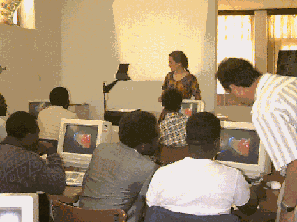
Training
Unquestionably the most visible component during the second phase was the intensive training series in GIS, Remote Sensing and Global Positioning Systems. Two groups from each agency went through a series of three training courses over a 14 month period. Although the original intention was to have the trainings much closer together, the interim periods were used to review techniques, practice tutorials, and for some agencies, engage in application projects.
The training sessions were held in April 1994, August 1994, January 1995 and June 1995. The Introductory courses, held in April and August of 1994, were intended to provide a broad overview to GIS, GPS and Image Processing and their uses in environmental research. The Intermediate courses held in August and January 1995, provided hands-on experience with database development issues and a strong exposure to change analysis procedures for environmental monitoring. The Advanced courses held in January and June 1995, covered database design and system implementation, error analysis, time series analysis, and procedures for multi-criteria / multi-objective decision making. Course outlines for each session along with a list of trainees can be found in Appendix I.
Although the techniques of GIS were stressed during each of the trainings, the use of GIS for environmental monitoring and analysis was an underlying theme. Trainees were encouraged to view GIS as more than a mere collection of techniques, but as a way of approaching, conceptualizing, and analyzing environmental problems. From this approach, GIS is seen as supplying more than just a collection of maps, but is viewed as a mechanism for developing alternatives for environmental decision making. Examples of using GIS in this dynamic mode related to issues important to environmental decision makers in Malawi and conducted by the trainees during the course of the training sequence can be found in Appendixes II - V. These included: drought monitoring, food security, forest change analysis, and landuse planning,
Other non-technical issues explored during the training sessions were those related to implementation and long-term system design. These issues were given a significant amount of emphasis during the training sessions and during all follow-up activities and included discussions on the organizational barriers to implementing GIS within each agency. Throughout, the trainings were used as a unique opportunity to identify problems and needs related to the technology transfer process.
Although the training process itself concentrated on techniques and the development of research capacities, there was also a significant emphasis put on longer-term system design and implementation issues. These are issues that are less than technical and focused on organizational needs, structures and the human capacity for adopting new technologies. Particular emphasis was placed on these issues in both the Introductory and Advanced sessions.
Pilot Projects
A significant component of the training process was the follow-up activities provided to each of the agencies. For two months immediately following each training session a trainer assisted each agency in follow-up activities. These included assisting in post-training tutorial exercises, additional training sessions tailored to agency demands, and the development of application projects. These projects were to be used as additional training aids, but more importantly, they assisted in garnering support within the agencies as they were tailored to address specific agency monitoring needs. These projects included: rainfall mapping using cold cloud duration and forest inventory mapping and can be found in the Appendixes VI and VII.
It was recognized early-on that realization of the implementation process would only come about through the support of the agency itself, and not merely the training of technicians. As a result, all agencies were involved in planning application projects that would serve the broader needs and interests within their agencies than just the monitoring of burley tobacco. Thus, through meetings from a cross section from each agency, the trainees were able to design the initial application projects which also served to broaden support for the technology transfer process.
Equipment
Prior to project development, it was determined that equipment would need to be purchased for each agency participating in the MEMP. Although the equipment was procured in the US, emphasis was placed on microcomputer hardware that could be serviced directly in Malawi. This included computers suitable for GIS and Remote Sensing and data collection equipment such as digitizers, tape drives, and in some cases, GPS units, GIS and Image Processing software, and peripherals for each of the agencies (such as printers) that could be considered the minimum needed to move from training to applications and analysis to map production with a minimal amount of training and assistance.
Within the general guidelines set out for sustainable development, emphasis was placed on the employment of technologies that have low initial and recurring costs as well as those being highly usable. In the long term, low-cost new technologies would be more sustainable if they could be demonstrated to be applicable at addressing agency needs. In the short term, however, these tools have had the effect of providing for higher returns on the initial commitments by each department and on the application projects developed during the early stages of the technology transfer process. As found in the Appendixes, many of these projects have significantly altered the view of these new technologies and are understood as being essential tools for environmental monitoring.
Professional Association
At the end of the first training session, a discussion was held to review the advantages of developing a professional association of analysts in GIS. Potential roles for such a group were reviewed by the Clark team based on experiences in a wide range of contexts. A provisional group of coordinators was elected at that time, with the eventual decision by all involved to reconstitute and revitalize an existing organization concerned with Remote Sensing. As further support to this activity, the Clark team lobbied for Malawian participation in the AFRICAGIS organization founded jointly by UNITAR, OSS, UNSO, WRI and USAID. Two participants from the Malawian association did participate in the AFRICAGIS'95 meetings in Abidjan, Cote d'Ivoire in March 1995, with funding from USAID.
Phase Three: Developing Management Support
With a growing awareness of what GIS and related technologies could do, not only in the context of the MEMP, but also the work of the agency as a whole, the development of upper-level management support became critical. Support for the activities of the MEMP itself was established through development of the ASAP MEMP component. However, at that time, the rationale for GIS and related environmental information technologies was only vaguely understood. The intention of Phase Three, then was to use the work of the first two phases as the basis for developing management support for continued activity in this area. Two instruments were critical to this process: the Pilot Projects already discussed, and a Decision Maker's Workshop in which direct and coordinated access to upper management could be achieved.
Pilot Projects
The pilot projects previously discussed, although useful as a pedagogical device, were also instrumental as tools for building technology awareness. As such they offered enormous potential to assist in the process of developing upper level management support. By using data collected by each agency on problems of direct relevance to those agencies, a clear evaluation of potential benefits could be achieved.
The Decision Maker's Workshop
In culmination of the first phase of activities under MEMP, a Decision Maker's Workshop was held in June 1995. The objective of this two-day workshop was to bring together environmental decision makers within the Government of Malawi in order to become familiar with the concept of GIS technology for environmental decision making. For more than a year government officers have been training and experimenting with GIS for use in environmental management activities such as forest monitoring, water quality, watershed planning, rainfall monitoring, and landuse planning. The seminar was a venue for assessing the progress thus far and to elicit the needs of Malawi's environmental decision makers for implementing GIS in Malawi for environmental monitoring.
Appendix VIII provides a complete listing of all those attending and the Workshop's agenda. The Workshop was initially opened with a demonstration and an overview of GIS technology followed by a discussion of GIS for environmental decision making, particularly related to MEMP activities. Eight pilot projects and research activities ongoing within the participating agencies were presented to the participants by representatives from each of the agencies. The selected presentations are found in the applications of the Appendixes. The demonstrations concluded with a landuse mapping and project planning case study presentation for Kamunde Catchment, Mangochi. This case study illustrated the effective use of GIS for decision making. Appendix V details this presentation.
As a final introduction to GIS technology, important elements of GIS system design were presented and discussed. In short, this session stressed the importance of planning for the implementation of any innovation, but especially GIS, within organizations. By this stage of the workshop, most participants were comfortable with the technology in terms of being able to converse and discuss appropriate needs and recommendations for future GIS activities within their respective agencies.
The final and most important aspect of the workshop was then to give each of the agencies the opportunity to discuss and present their needs as an agency, as well as, to develop initial plans for implementing GIS for addressing environmental management concerns within their agencies. Appendix IX is a summary table of each of the agency presentations regarding needs for GIS and possible barriers to implementation. The results of this workshop have been instrumental in assessing the program's progress. It has also been crucial in gathering additional support for GIS activities in Malawi through the broader sensitization the Workshop provided to senior government officers.
Phases Envisioned for the Second Funding Stage
As indicated in the earlier section on project design, the initial stage of funding was envisioned to carry the project only through to the end of Phase Three, with an expectation of perhaps 2-3 years of subsequent funding through other mechanisms. As of the writing of this report, productive discussions are proceeding on this front. However, a workplan has not been finalized. As a consequence, the considerations presented below are only preliminary in nature, and will be modified to take into account the recommendations that conclude this report.
Phase 4: Applications, EIS and Human Resources Development
Within each of the agencies involved in the MEMP, a number of products were identified in the context of the pilot projects and Decision Maker's Workshop that were suitable for development as operational applications. Examples here include topographic and infrastructural data from Surveys, coordinated climatological data from Met, land cover data from LRCB, and so on. It is envisioned, therefore, that more specifically targeted assistance (such as short-term expert technical assistance) would be provided to facilitate the development of these as on-going products using GIS and related technologies. The intention is that these products would form the foundation for a National Mapping Program that would serve as the basis for a developing Environmental Information System (EIS).
Given the national scope of the MEMP, the development of an EIS is seen as a major infrastructural requirement for the further evolution of this national monitoring capability. Appendix X provides a framework for discussion for such a system that is intended as a focus for discussion in developing a final design. While it is expected that considerable progress will be made in articulating such a plan, it is not expected that complete implementation is possible within the limited time frame of this second funding stage.
In addition to these specific EIS-related applications, it is expected that a series of environmental monitoring projects will be forthcoming through the MEMP structure that will require the agency teams to move beyond an experimental mode. Again, the requirement for short-term technical assistance is anticipated. However, there will clearly be a need for a continuing flow of trained personnel: in part through continued in-country trainings, but increasingly through the development of an in-country university-based training and education capability. Thus, it is planned that a training program be developed in conjunction with a host-country university institution, with the intention of developing an indigenous training and educational capability by the completion of the project. As a consequence, Phase Four is intended to overlap with Phase Five.
Phase Five: Transitional Phase
As indicated in the earlier section on project design, the final phase that is envisioned for the project is unquestionably the most ambitious. It concerns the transfer part of technology transfer, not as a packaged donation of goods, but as the handing over of a process of implementation. For this to happen, it is important that management support be strengthened and solidified, and that the core teams be augmented and transformed into true development teams. These teams will need to undertake a formal needs assessment, establish an initial project design, and to develop short- and medium-range fiscal and human resource development plans. This latter aspect is of crucial importance. While it is expected that donor assistance may be called upon for specific elements of these plans, it is critical that they provide contingencies for continued development without donor support.
As indicated earlier, to have the final phase of donor-funded activity be called the Transitional Phase underscores the emphasis on self-reliance in the Ecological Approach. By the end of this stage, it is envisioned that each agency will in fact be productive with GIS and related technologies to a certain degree. Primarily this will be of the nature of the provision of a limited number of specific information products along with the general capability to support the use of these technologies as part of specific research initiatives. However, for each of the agencies involved, it is likely that the process of articulating the potential applications of these technologies to the functional operations of that agency will uncover a much more far-reaching role for which a long-term implementation strategy will be required. Activities during post-transitional stages will thus likely include the further development of standardized information products as part of the national mapping program (a key element of the EIS), the establishment of a formal management subsystem, with companion subsystems for continuing data provision and information product use, and a continuous process of self-analysis and respecification of technological needs and implementation strategies.
Evaluation
Introduction
The purpose of this section is to evaluate the Ecological Approach to technology transfer in Malawi. Our intention was to address the lack of appropriate uses of GIS and unsustainable transfer programs from this Ecological Approach. However, without a history of case studies to draw upon employing this approach, this is clearly difficult to do. At this stage, all that can be done is to provide a critical examination of the Malawi case study at its current state of development, and try to evaluate the degree to which we believe that the problems experienced are an inherent problem with the approach itself.
There are two broad categories of criteria that can be assessed. First, although five phase objectives of the ecological approach were outlined for the Malawi Project, only the first three objectives can be evaluated at this time. This is due to the long-term nature of any technology transfer process. These objectives will be evaluated to the degree to which they have been positive contributing factors for the transfer process overall. Second, it will be assessed if the established criteria for the Ecological Approach have been met and contribute to the sustainability and feasibility of the Malawi Project.
Evaluation of Phase Objectives
Phase One: In-Country Orientation and Infrastructual Assessment
The objective of this first phase was to establish the logistical details of the project. The goal was to marry the resources at hand with the preliminary needs of the Government of Malawi. It was crucial, then, that the state of the GOM infrastructure be assessed. This was a demanding task as there were six government agencies involved in the project, each requiring their own sensitization process to the project. The information gathered during this phase proved to be invaluable for guiding subsequent activities.
Key to this preliminary evaluation was the assessment of the staff resources within each of the agencies, and within the GOM overall. It was assessed early on, for example, that there was a lower than anticipated level of education within the government staff. It was not anticipated that the basic educational level of the staff would require a significant amount of retraining, or, in most cases, basic training in statistics and geographic analysis. This combined with a low level of ongoing research at the government level significantly deterred, and will continue to deter, the transfer of GIS and related technologies.
Other issues that contributed heavily into the initial design and redesigning phases were the general level of health and the subsistence like level of economy of the GOM staff. Although some of these issues were anticipated, it was never anticipated at the levels at which they occurred. More importantly, it was not anticipated that staff would resort to such activities that are, more or less, poverty alleviation strategies on their part. What has been dubbed the Workshop Syndrome could not have been anticipated at the outset. This included the interaction between the donor/host country, which is itself, a mitigation strategy at the highest level.
It is significant to note, then, that the information gathered during this phase was instrumental for all future activities. This stresses the importance of initiating the Malawi Project through an orientation process and infrastructural assessment, without which, all future activities would have proven either more difficult or impossible to overcome.
Phase Two: Building Technological Awareness and Development of Core Teams
It is instructive to note that the phases outlined overlap and should not be thought of as a linear model. The gathering of infrastructural information is not static. From the preliminary information gathered during the in-country orientation phase, core teams were organized within each of the participating agencies who then participated in an intensive sequenced training program. Besides becoming immediately productive in GIS technology they were also instrumental in creating broader awareness within their respective organizations.
The core teams for each of the two training sequences were comprised of largely technical staff, primarily senior level officers. For the most part, the planning of an intensive training sequence was successful and was supported by all the agencies. Each agency contributed two or more of their staff to attend each of the two training sequences. Given the difficulty in acquiring GIS skills and adapting them to local environments, the intensive in-country training program was the most practical vehicle for getting as many government officers and agencies up and running. Given the general health issues and the instability of government level staff, it became even more evident that this approach would be the most effective means for a training process.
In conjunction with the intensive training sequence, the post-training activities did turn out to be one of the most productive exercises of the program. Although only one trainer was available for only two months following each training session who was then divided among each of the six agencies, the pilot projects developed during this period contributed significantly to the awareness process (see Appendixes). The pilot projects were instrumental in applying and developing further, the GIS skills acquired during the trainings. Because the pilot projects were developed in-country with data, for the most part, available in country, this contributed in garnering support. Most often, GIS is demonstrated with data and analyses that is generated from outside which quickly results in a lack of affinity for the technique, if not the technology itself.
The intensive training campaign did prove to be the most effective means of casting the GIS net, although, it still must be cast wider. The instability of government officers has had a devastating impact on the project overall. Even without the effects of the Workshop Syndrome, many of those trained either succumbed to professional flight or moved up in their departments. Moving up meant acquiring a host of other responsibilities leaving no time to pursue GIS or MEMP related activities. The Department of Forestry offers the best example. From the beginning, they were the most promising of the departments from a technical standpoint, as well as, being in a desperate need of acquiring alternative tools to tackle their extreme deforestation problem. But of the four officers trained only one remained attached to the MEMP program. Although, even he is no longer capable of performing GIS duties as he is now saddled with upper-level management responsibilities.
What has had a further severe impact on the project was the overall makeup of the trainees and their inability to contribute to research and the broader awareness campaign that is needed at much higher levels within each of their respective agencies. As it turned out, the level of government officers recruited as trainees was inadequate for these tasks which requires a much broader level of recruitment to both engage in research and to access a much higher level of government officials during the awareness campaign, especially at the Principle Secretary level. The attitude within the government itself is partially to blame for those recruited and their inability to engage in research and perform certain duties. The general perception within the government is to keep those engaged in technical activities distanced from research design, which itself occurs at higher levels. Participating and guiding research is instrumental for employing GIS and the current level of trainees are not in such a position.
Phase Three: Developing Management Support
The final phase attained by the Malawi Project has to do with garnering a broad level of support within each of the participating agencies and within the other GOM departments as well. As the project progressed it became apparent that without much higher levels of management support it would be difficult, if not impossible, to sustainably transfer GIS technology. Almost all of the agencies could not sustain a dedicated GIS technician who could perform MEMP related activities or continue prolonged training and pilot project development. Although it was generally recognized that GIS could have a significant impact on ongoing work activities, a much more intensive and effective means of creating awareness was needed within the program that went beyond pilot project development. This was accomplished through the Decision Maker's Workshop discussed in previous sections.
The Decision Maker's Workshop was an important opportunity to critically evaluate the Malawi Project by the participating agencies. Attended by more senior level officers in each of the agencies, it did much to heighten awareness and generate support within the GOM by providing a structured assessment of the technology transfer program thus far and an opportunity to discuss future needs. A detailed survey of the agencies participation in the Workshop is found in Appendix IX.
Each agency was asked to articulate major barriers to GIS implementation in Malawi. It is evident that the majority of the responses were not technical in nature, but rather organizational and related to the quality of the work place. There was a concern, however, of the need to increase skills that are known to be seriously lacking. Although categories related to technological barriers, such as equipment and data, were identified, it became apparent to those involved in the transfer process over the past eighteen months that without long-term financial and human support for the technology, mere appropriations would not be very useful.
The ability to sustainably institutionalize the required human resources for GIS activities was identified as a major obstacle within the current GOM infrastructure. Most agencies underestimated the required amount of resources needed to utilize GIS, but even if they had foreseen the need, the GOM infrastructure does not accommodate or give special recognition to technical disciplines, only to administrative or political positions. Without a restructuring of the civil service, it was generally decided at the Workshop, no government officer or agency could successfully use GIS on a continuing basis.
Data were also given consideration during the Workshop. It is often a misnomer that GIS begins with data. Many GIS technology transfer projects wrongly begin by developing complete national or regional datasets, when in fact, like the use of the technology itself, the availability of data should only be an afterthought once the problem is defined and how the technology can be used to address that problem. Although data were considered an important barrier during the Workshop, it was not considered the most important. It should be considered a success of this project that there are indeed other more demanding obstacles put to the forefront.
Evaluation Criteria
The criteria evaluated fall into two categories. The first set addresses the overall sustainability of the Malawi technology transfer project and its potential for becoming a functional and self-supporting activity within the GOM. The second set of criteria address the feasibility of GIS being implemented given the socio-technical constraints within a developing country context and the constraints of donor project life spans.
Ecologically Focused
The ultimate aim of the technology transfer project was to implement technologies that can contribute to more effective and efficient environmental decision making. This is accomplished when innovations meet stated organizational goals and needs. This is the heart of the ecological approach, but it is the most difficult to evaluate, especially given the two year time frame. By its very definition, the project described here has been ecologically focused. What can be evaluated, however, is the degree to which it has been successful in articulating the functional role of the participating agencies and the potential use of these technologies in meeting their stated goals and needs.
From the very beginning of the project each department was encouraged to articulate their respective needs and goals. The project was successful in demonstrating appropriate uses and applications of GIS at meeting many of those needs as evidenced by the various application projects developed in cooperation with the agencies. One particular application at the Department of Forestry provides an example. The DOF articulated the need to monitor its extensive forest plantations. The application project developed by the DOF was to map the Chongoni Forest Plantation in Central Malawi (Appendix VII).
Using recent maps surveyed through traditional chain and compass and a database on the forest compartments, the plantation was digitized and imported into the automated GIS environment. To have ready access to a mapped database, if only to spatially represent the species distribution, proved to be a highly successful demonstration of GIS for decision makers within the DOF. They have subsequently become only the second agency to set aside a dedicated GIS Lab.
Demand Driven
The ecological focus resulted in the articulation of needs for GIS technology. For GIS to be sustainably implemented it was demonstrated to be an added benefit over other technologies or innovations that address similar needs and demands of the departments. The case in point is the use of GIS over traditional methods for landuse/landcover (LULC) mapping at the LRCB. Using remotely sensed satellite images and image processing software LRCB is now capable of creating more timely and highly accurate LULC maps for various areas in Malawi.
Traditional LULC mapping is usually accomplished through aerial photo interpretation. Almost all national surveying departments, including many natural resource departments, have this capability. In many cases the use of air photos is quite adequate for LULC interpretation, provided the appropriate photos can be obtained. But the use of this technology has its limitations, primarily when larger scale mapping is needed in areas of highly varied vegetation cover. The African landscape, especially in Malawi, is quite diverse and can not be generalized at the larger scales.
Appendix XI shows the results of using both technologies. LRCB was asked to create a large-scale LULC map for a study area in Central Malawi from aerial photography and manual methods. Later, taking a considerably less amount of time, two days versus four months, a LULC map was created from SPOT 20 meter resolution satellite imagery. The difference is striking. The satellite imagery was able to capture the local variability and the patch-work landscape most often found in rural Africa. Considering the cost of the aerial photos and the time to create the LULC map, digital image processing of satellite data promises to significantly increase an organizations function to detect and map changes in the environment with a higher level of accuracy.
Accurate and timely LULC maps are essential for environmental management. This newly demonstrated method has generated much interest within the departments, especially in LRCB. Currently, LRCB is engaged in a project to produce LULC maps at the district level in order to provide more accurate information of landuse changes. Having demonstrated the potential, many decision makers are enthusiastic and support this research and look forward to more timely information on their environment.
One further example can be drawn from the Department of Meteorology. Their primary responsibility is to report dekadally on rainfall and temperature anomalies for the country. They currently have over 200 rainfall stations throughout Malawi, although they rely on approximately 100 for their reporting. One of their products is a monthly composited rainfall map approximating the variation in rainfall over the entire country. This is an interpolated rainfall map from approximately 30 of the most active reporting stations.
They have at the same time, access to satellite data that supplies information on atmospheric conditions over Malawi on a dekadal basis, Meteosat Cold Cloud Duration data (CCD). This data was used for a pilot project that explored the development of more accurate rainfall coverages for Malawi than simple point interpolation. Using regression analysis, the rainfall maps were produced from the CCD maps after calibrating them from the known rainfall point data, a process that can only be carried out with a GIS (Appendix VI).
Not only did this example generate interest within MET, but it had added impact within the Department of Water. It is of vital interest to DOW to calculate the direct recharge rate of Lake Malawi, primarily for energy purposes. Currently, DOW has plans to place rainfall recording buoys throughout the lake. This would not only be an expensive undertaking but it would also have the same interpolation results encountered at MET when using point data. Using rainfall maps derived from the CCD, direct recharge rates can now be calculated without the need for surface interpolation. This should prove to be not only more accurate but also significantly less costly as the data is already being collected at MET.
Participatory
Demand for GIS technology can only come about through a greater awareness of the tools and the products they are capable of delivering. This in itself is the result of broader organizational participation. A pivotal criterion of the Malawi Project and the Ecological Approach was the involvement of the agencies and their participation from the very beginning. Each agency was encouraged to participate in placing demands on the technology and the project. Although there was concern at the early stages of the project, both from the donor community and from Malawi counterparts, that the project was not moving in a timely fashion, the process of developing relationships is not one that can be associated with a time schedule. This is such an integral part of the participatory approach and it is a prerequisite before any of the agencies can feel that they are becoming part of the process themselves, and to even one day, own it outright.
Where participation occurred more often, especially within DOS and LRCB, a more well articulated set of demands was formulated for which the technology could improve overall agency effectiveness. The most sustainable use of the technology, at least in the exploration stage, is at the DOS. Of all the agencies, they have met regularly with a broad level of decision makers within their agency. They have even set-up a formal sensitization process whereby they hold half-day sessions with various departments within the agency. This has had the effect of both raising the level of awareness, as well as, gaining longer-term support for their ongoing GIS activities. Until a recent governmental budget crisis, they had effectively budgeted for their own acquisition of hardware and software.
However, increasing levels of awareness throughout most of the agencies is only now beginning. Until there is a much broader sense of awareness it is difficult at these stages to actively engage a broader group in participatory planning practices. However, the Decision Maker's Workshop did much to confirm the importance of this criteria. This all important venue highlighted how essential it is to have as a continual activity the active participation and involvement of the agencies in their own destiny.
Socio-Technically Focused
The long-term adoption of new technologies within a workplace is more than just the selection and acquisition of the appropriate technology to meet specific demands. The Ecological Approach is possible because there are people involved who are ultimately impacted and impact all development processes. The implementation of innovations with a socio-technical focus implies foremost that it is people who benefit from these new technologies and who will ultimately accept or reject their use.
From the early stages in the process the aim was to increase organizational awareness in order to garner that human support for the new technologies. This was often difficult as the awareness process is a long-term one. The lower than anticipated level of education and research capabilities has made for a slow process overall.
Appropriate Technology
The appropriateness of technology is based on the technology's capability to be employed while not interfering with ongoing operations, both in terms of being financially sustainable and from a human resource potential. Clearly, it is much too early in the technology transfer process to evaluate this criterion as the agencies themselves have found it difficult, if not impossible, to allocate appropriate human and financial resources for GIS initiatives. As mentioned earlier, given the current GOM budget crisis the agencies are incapable of budgeting for 'capital' expenses and are allowed to work only on monthly budget cycles.
The DOS is clearly the only agency, before the budget crisis, that had demonstrated the budgetary responsibility needed to support long-term technology adoption. As stated above, they had already been committed to purchasing hardware and software that could meet the stated demands of that agency. These appropriations were not seen as displacing ongoing activities, but instead, they were viewed as significant enhancements. For example, DOS purchased hardware and software to explore digital data entry directly from analytical plotters. This process will significantly enhance their capability to create mapped databases and to supply decision makers with more timely information. Unfortunately, the other agencies have been slow to follow DOS's lead. But this in itself demonstrates the importance of creating technological awareness so that innovations are accepted when appropriately applied.
Focused on Self-Reliance
The implementation of technologies can not be considered a static phenomenon. Thus, it is vital that local support for innovations from outside be developed. There is a strong tendency and historical evidence to show that the introduction of new technologies that initially rely on external resources creates a strong atmosphere of dependency. It is then difficult to fully transfer these innovations when one of the objectives is to develop long-term self-reliance.
This is indeed the case in Malawi. The impetus for the project was a USAID initiative to monitor the effects due to an agricultural policy change. Throughout the first two years of MEMP each agency was supported through funds supplied through USAID. During this time, no agency self-initiated any GIS related activities that could not be accounted and paid for through these MEMP funds. This in effect, is the state of donor dependency prevalent in developing countries that host countries have found difficult to wean themselves from when moving toward self-reliance on development initiatives.
Coupled with the subsistence-like economy found in the government sector, it is unlikely that there will be a change in the near future. The type of change needed is basically a structural change within the GOM which implies a long-term commitment, but one, however, most agencies are aware of. It was recognized during the Decision Maker's Workshop that an infrastructural restructuring would be a prerequisite to sustaining GIS within the agencies.
A noted exception, however, did occur at LRCB. Through their own initiative, two of the trainees have been exploring the use of GIS for better landuse management at the local community level. They have developed a proposal for this research and have actively sought out GIS technical advice. Although this is the most advanced case, the determination of all the of trainees from each of the agencies was evident in that they actively sought out GIS advice and support throughout from the GIS and MEMP technical advisors.
Process Oriented
An important characteristic for any organization is its ability to adapt to change. Pressures from both outside and within the organization are typically assumed to occur as a normal part of societal interaction. Thus, organizations must be flexible enough to adapt to this change. It should not be understated that full implementation then of GIS is likely to take years as organizations learn to develop mechanisms to adapt newly acquired innovations.
During the initial stages of the Malawi Project, many of the participating agencies did not anticipate the long-term nature of the transfer process. In part, this was fueled by the donor community that created heightened expectations of the technology and, who assumed themselves, that the transfer of technology was, more or less, the mere acquisition of hardware and software. That the transfer of GIS is a process was articulated from the very beginning of the project and continued throughout the trainings. This was further emphasized and reached a much broader audience during the Decision Maker's Workshop. The result is very much evident. Together, the donor community and especially the GOM, have undergone a change of attitude towards the technology as the project has progressed. There is a much more heightened sense of awareness of the long-term nature of the technology transfer process.
Phased Evolution
In order for the adopting agencies to successfully plan for the adoption of innovations a clear plan must be developed. This implies that all the above criteria are planned for and included in a strategic plan that clearly states objectives and self-supporting funding mechanisms. This clearly was not achieved given the time frame of the current Malawi Project activities. Although the importance of this planning activity was incorporated into the training sessions and the Decision Maker's Workshop, it is inconceivable that long-term planning can be articulated without a broader awareness and participation by the individual agencies.
Conclusion
It can not be overstated that the transfer of innovations must be a planned, long-term process. So often this process is planned unilaterally without mutual participation. This is a prescription for failure. We have taken a different approach and have tried to operationalize it in the context of the Malawi Project. The success we can claim overall is the willingness on the part of our Malawi counterparts who have remained enthusiastic and have embraced the process, and not the technology. Because we now have the support of USAID and who recognize the long-term nature of the process as well, it is assumed that more successes will be inevitable.
Recommendations for the Malawi Implementation Project
Introduction
This report has been centrally focused on the issue of GIS technology transfer in the developing world, and has used a case study project in Malawi as a medium for the development and evaluation of what has been termed an Ecological Approach. Given the evaluation of the stages completed to date, we do not find reason at this stage to alter the character of the Ecological Approach that has been developed and recommend it for the development of subsequent GIS technology transfer projects in both the developed and developing world. However, there are a number of recommendations for specific alterations to the implementation undertaken in Malawi that arise from this evaluation and should be considered for follow-on activities under MEMP. These recommendations come from our own observations, input from USAID, and from the GOM, especially as a result of the Decision Maker's Workshop.
Continued Sensitization
Although awareness and interest in geographic information technologies has been increasing, it has been comparatively slow which has resulted in a slow diffusion and adoption process. As a result, it has been difficult to maintain a sense of commitment and continuity among the trainees, as well as, a maintenance of support from their sponsoring agencies. Although GOM officers are well trained to carry out their respective tasks, a broader level of awareness is needed to adequately commit those participating and to ensure a more effective use of the technology within their respective agencies. This could be accomplished by including senior level researchers and scientists from each agency to be involved in GIS training as well. These would be scientists within each of the agencies who can articulate and initiate research agendas. This would complement the currently trained technicians from ASAP I who are now able to carry out fundamental data development and analysis. Given the time constraints of the senior level officers, the attempt should be to make them GIS literate in the shortest amount of time, possibly through a two week intensive sensitization. This would also aid in enhancing the use of GIS for environmental research overall.
A major conclusion of the Decision Maker's Workshop was the need to begin sensitization and develop support at a much higher political level within the GOM. It will be important that at a minimum, the level of the Principle Secretary should be made aware of GIS technology and its opportunities within the GOM. This may best be accomplished by holding a session similar in format to the Decision Maker's Workshop for very senior level management.
During the first phase there has also been success in working with government officers in the ADDs. These government officers are closer to the local resource problems and thus seem better able to articulate research agendas that have immediate impact on environmental monitoring and, mitigation. The landuse mapping analysis and activities being conducted by one of the trainees who resides in the Mzuzu ADD will do much to increase awareness at this level. Thus, there should be added focus at decentralizing the implementation process away from the departmental offices towards the field at the ADD level.
Overcoming Scientific and Research Deficiencies
One of the most significant barriers to the adoption of GIS over the last two years has been the lower than anticipated level of scientific and research expertise of the trainees and their lack of capacity to initiate, conceptualize, articulate and conduct independent scientific research within their agencies, especially research design related to environmental management. Although these trainees have been adept at acquiring the fundamentals of GIS, a much broader range of skills are needed to efficiently employ these new technologies. Emphasis must be placed in subsequent activities at enhancing these technical capacities within each of the participating agencies.
A long-term mechanism for addressing this deficiency will be to institute a GIS education and training process in Malawi. At the university level, two committees, the Post-Graduate Research and the Academic Planning Committees, must be involved in any long-term curriculum planning, including the identification of suitable sites for initially housing a 'GIS Lab' and training center. During the months of August and September University faculty are free to attend refresher courses. This would be an appropriate time for offering GIS training for faculty in order to expose and identify suitable faculty as long-term trainers in GIS. However, it is clearly evident that there is a lack of any local expertise to develop curricula and training programs in GIS. As such, one of the colleges should have posted a long-term technical advisor/faculty member with the responsibility of developing GIS curricula, research and training programs. This can be initiated in conjunction and in coordination with the MEMP GIS trainings in order to build and institutionalize local level capacities.
Thus, there is a need to continue the intensive training process for GIS technicians in order to ensure a continued stream of GIS analysts within the agencies currently participating in MEMP, as well as for any agencies wishing to participate in the future. This will also ensure that the awareness of GIS and its current uses for environmental management continues. Minimally, three trainings should be conducted over any 12 month period for government officers. These trainings should also include follow-on advanced sessions specifically targeted to applications and areas of technological interests that address agency specific problems and mandates. These could be conducted through short to medium term technical advising.
Infrastructural Adjustment
A significant barrier for the sustainability of the technology has to do with the bureaucratic and financial infrastructures currently in place in Malawi's civil service. The reality is that Malawi civil servants are vastly overworked and undercompensated. This has resulted in low morale and a level of absenteeism, although sanctioned, to attend the many donor sponsored workshops and trainings. Although these activities offer positive contributions in general for government officers, their frequency has had the tendency of disrupting ongoing work assignments. The lure, of course, is the over compensation paid out to attendees. In most cases, attending a weekly workshop will earn a civil servant more than a month's salary. Even more, a trip overseas can easily be equivalent to a year's salary. This has had a significant impact on the quality and quantity of work being performed on a routine basis, let alone the new tasks they are being asked to perform as a result of this project.
Currently there is no personnel structure in place that can accommodate the technical, educational and salary requirements for GIS analysts. This deficiency, as articulated by government officers, will significantly lessen the chances for success. Government officers can not adequately carry out these new activities without an infrastructure in place or proper compensation for employing the newly acquired technical knowledge and expertise. A recommendation would be to put in place a professional level within the civil service and to have it be financially attractive. This recommendation may be the boldest but it is by no means out of place. The acquisition of new technologies should merit a rethinking of existing structures and suitable accommodations where necessary.
A GIS User's Group was established early-on in the project with representatives from each of the participating agencies and other interested departments, including other donor sponsored projects. Initial interest waned as it was quickly recognized that without formal acknowledgment by the GOM in terms of financial support and bureaucratic recognition for a GIS or technical user's group, it could not have enough influence. The formalization of this group is currently on hold but should be encouraged for any future activities. In particular, it could play a vital role in the development of a suitable civil service professional grade.
Donor Coordination
This project to introduce new geographic information technologies in Malawi was not the first and certainly will not be the last. As mentioned earlier, a lack of donor coordination has significantly affected the project's ability to function properly. At the very least the GOM should establish a technology committee to meet regularly with donors and to assess their various technology initiatives and to plan and coordinate so as to reduce redundancy and conflict among the donors, as well as within the GOM.
National Level System
As initially conceived, the MEMP was intended as a national monitoring system. As a result of the World Bank sponsored National Environmental Action Plan (NEAP), considerable interest has been expressed in the extension of this activity to the development of a National Environmental Information System (EIS). The decentralized character of the MEMP is inherently compatible with this logic, as any such enterprise will logically be a multi-sectoral effort.
In a piece prepared as a discussion document for USAID and MOREA in April 1994, a structure was proposed for an EIS that was seen as a consistent development from the decentralized structure of the MEMP. Key elements of this structure included an overall multi-sectoral coordinating body, a National Mapping Program of coordinated digital data sets to support the application of GIS and related technologies and evolving educational program, and an information coordination and dissemination agency (most likely, MOREA itself). Details of this proposal can be found in Appendix X and will be used as a starting point from which to proceed in the development of future EIS acitivities. However, we recommend that movement towards such a goal proceed hand in hand with the development of the MEMP.
Long-Term Commitment
In addition to these recommendations, it should be emphasized that the implementation of GIS for environmental management and monitoring in Malawi will require a long-term commitment by both the GOM and the donor community. Although many of the technical barriers to implementation can be initially identified and addressed, long-term sustainability, i.e., institutionalization, of the technology will require coming to grips with and overcoming the issues and barriers related to developing the human and organizational capacities to absorb these new technologies. A significant advancement that this report can point to is that the GOM is now aware that the implementation of GIS is more than just the acquisition of technology -- i.e., the procurement of hardware and software so often associated with GIS. Rather, it would appear to be clear to all involved that in order to move forward toward sustainable technology transfer, a much heightened level of involvement is needed by both the participating agencies, the GOM, and the donor community.
APPENDIX I: GIS Training Course Outlines
[ text]Introductory Course
Introduction to GIS
Raster Data Structures
Analysis in GIS
Database Query
Map Algebra
Distance / Context Operators
Vector Data Structures
Vector Analysis
Introduction to Remote Sensing
Image Exploration
Digital Image Processing I: Image Restoration
Destriping
Rubber Sheet Resampling
Digital Image Processing II: Image Enhancement
Contrast Stretch / Compositing
Digital Image Processing III: Image Classification
Unsupervised
Supervised
Digital Image Processing IV: Image Transformation
Principal Components Analysis
Vegetation Index Mapping
Image Ratioing
Introduction to Global Positioning Systems
Ground Truth of the Njolomole/Mlangeni Case Study using GPS/GIS
Completion of Land Cover Mapping of Case Study Area
Accuracy Assessment
Data Entry
Data Transformation
System Design and Evaluation
Open forum: GIS and MEMP
Intermediate Course
Database Development
Raster Data Structures
Raster Data Import
Raster Interpolation
Database Import/Export
Change Analysis for Environmental Monitoring
Pairwise Comparisons
Quantitative Data
Qualitative Data
Multiple Image Comparisons
Image Deviation
Change Vector Analysis
Image Sequencing
Temporal Profiling
NDVI Differencing
Landcover Change Analysis
Advanced Course
Georeferencing and Geodesy
Uncertainty and Error
Multi-Criteria/Multi-Objective Decision Making
Time Series Analysis
System Design
List of GOM Officers Receiving GIS Training
APPENDIX I: GIS Training Course Outlines
Introductory Course
Introduction to GIS
Raster Data Structures
Analysis in GIS
Database Query
Map Algebra
Distance / Context Operators
Vector Data Structures
Vector Analysis
Introduction to Remote Sensing
Image Exploration
Digital Image Processing I: Image Restoration
Destriping
Rubber Sheet Resampling
Digital Image Processing II: Image Enhancement
Contrast Stretch / Compositing
Digital Image Processing III: Image Classification
Unsupervised
Supervised
Digital Image Processing IV: Image Transformation
Principal Components Analysis
Vegetation Index Mapping
Image Ratioing
Introduction to Global Positioning Systems
Ground Truth of the Njolomole/Mlangeni Case Study using GPS/GIS
Completion of Land Cover Mapping of Case Study Area
Accuracy Assessment
Data Entry
Data Transformation
System Design and Evaluation
Open forum: GIS and MEMP
Intermediate Course
Database Development
Raster Data Structures
Raster Data Import
Raster Interpolation
Database Import/Export
Change Analysis for Environmental Monitoring
Pairwise Comparisons
Quantitative Data
Qualitative Data
Multiple Image Comparisons
Image Deviation
Change Vector Analysis
Image Sequencing
Temporal Profiling
NDVI Differencing
Landcover Change Analysis
Advanced Course
Georeferencing and Geodesy
Uncertainty and Error
Multi-Criteria/Multi-Objective Decision Making
Time Series Analysis
System Design
List of GOM Officers Receiving GIS Training
From April 1994, almost twenty government officers were trained in GIS and remote sensing techniques. The intensive training process included classroom hands-on instruction, as well as, training in the field. As much as possible, local data sets were adapted for the trainings. Figure 1 is a typical training scene being held at MOREA. Figures 2 and 3 show the illustrate the application developed during the introductory trainings in which the trainees assessed food security issues in Malawi using NOAA AVHRR Satellite Imagery and production data supplied by FEWS Malawi.
|
Figure 1: The classroom setting. Classes were held at MOREA in Lilongwe, Malawi using equipment provided by USAID as part of the Malawi Environmental Monitoring Project.
|
Figure 2: A pair of temporal profiles developed from 103 consecutive months of NDVI imagery. The technique used for the analysis examines all pixels that fall within each of two Rural Development Projects (RDP's) and calculates their mean for each month. The Intermediate class that conducted this analysis noted that many districts exhibit a decreasing trend in apparent NDVI over the eight year sequence. Analysis of this trend formed part of the follow-up advanced training course.
|
|
Figure 3: A map of food security assessments for 1994 that was compared to an analysis of change in vegetation levels by the introductory trainee class. A significant statistical relationship was found.
This application was developed during the training sequence and illustrates the change detection procedures that were learned by the trainees and their application to environmental monitoring. The application used monthly vegetation index (NDVI) data from the Famine Early Warning System (FEWS) program to examine anomalies from January to May 1995. Difference images were processed into Standard Deviation classes (Figure 1). The analysis was able to show a movement in the main drought cell from Namibia/Botwana in January to Zimbabwe to Southern Zambia in May. The same sequence of images were produced for January to May 1987, the last significant El Niño drought (Figure 2). The similarities are dramatic and are characterized by the compilation maps for each year showing monthly maximum anomalies in vegetation over the same months for the two years (Figure 3). Companion images for each composite shows the relative trend surface, or best fit surface, in order to detect the general trend in movement from the southwest to the northeast. It was during the course of the training GIS training and exploration by the trainees that detected the 1995 El Niño drought back in July 1994. Figure 4 shows the precursor image that tipped off this trend and shows the change in mean vegetation between July 1993 and July 1994 with the drought cell forming in Southern Africa. July 1994 was the first month the trainees began their monitoring exercises.
|
Figure 1: Drought cell formation precursor image for Southern Africa showing difference in standard deviation units in mean vegetation between July 1993 and July 1994.
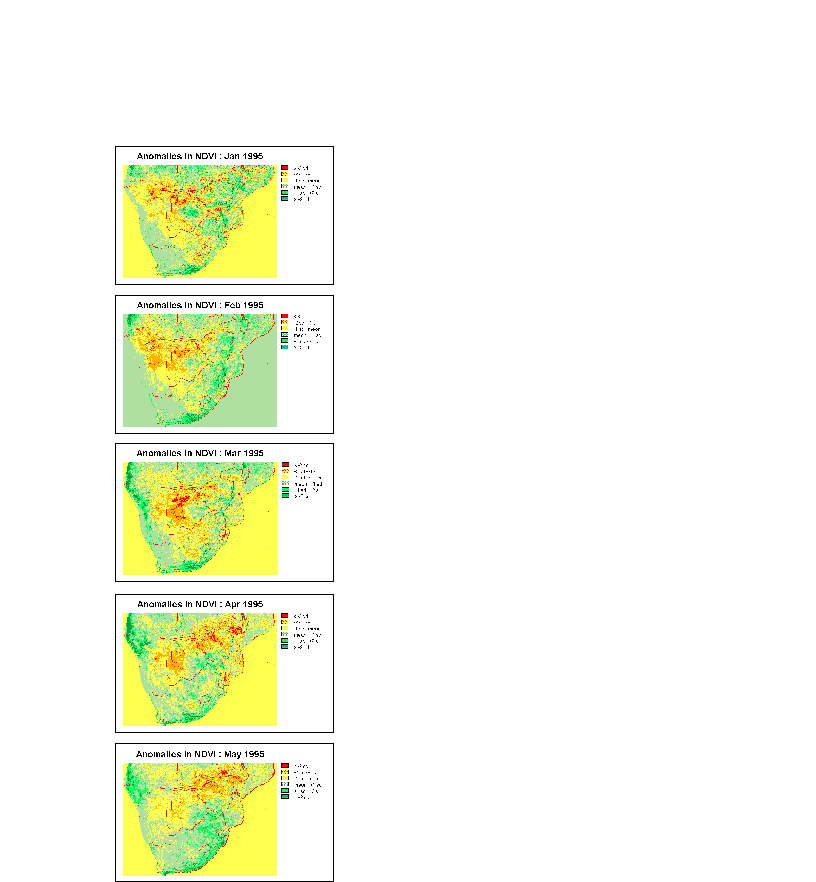 |
Figure 2: Anomalies in standard deviation units from seven year normals, 1995.
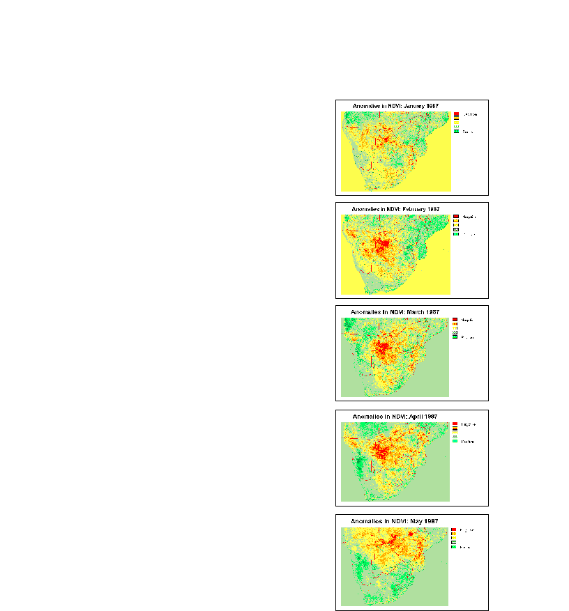 |
Figure 3: Anomalies in standard deviation units from seven year normals, 1987.
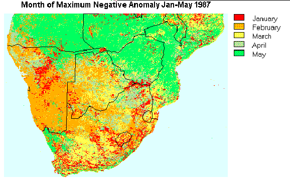 |
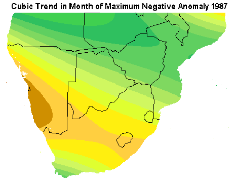 |
| 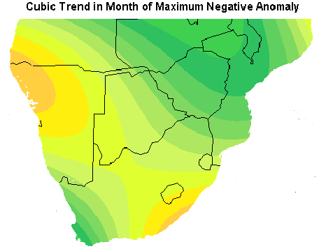 |
Figure 4: Compilation maps for each year showing monthly maximum anomalies in vegetation over the same months for the two years 1987 and 1995. Companion images for each composite shows the relative trend surface, or best fit surface in order todetect the general trend in movement from the southwest to the northeast.
Appendix IV: Forest Change Analysis
This application developed during the trainings illustrates the use of GIS and remote sensing for monitoring natural resources. The study employs a technique known as principle components analysis which seeks to isolate changes in vegetation over many years. In this case study, 84 months of AVHRR satellite imagery data, from 1987 to 1994, were analyzed to detect changes in vegetation using standardized NDVI, normalized difference vegetation index. NDVI is an index derived from reflectance measurements in the red and infrared portions of the electromagnetic spectrum to describe the relative amount of green biomass from one area to the next. Figure 1 shows Component 6 from the analysis which successfully isolated changing negative anomalies in vegetation cover (darker red and blue) related to the changing Malawi Forests over this same seven year period. The two graphs in Figure 2 show the significant decline in vegetation for all protected forests in Malawi and one selected forest reserve, Phirilongwe. To further verify the results of this methodology, larger scale analysis was used that employed Landsat MSS 80 meter and Landsat TM 30 meter. Figure 3 shows false color composite images for the two years 1981 and 1991 for the Phirilongwe Forest Reserve located in Central Malawi. The red in both images show the extent of vigorous growth from the forest cover and its significant decline over the 10 year period until 1991. This application demonstrates the relatively inexpensive and rapid analysis available using GIS and remote sensing technologies using the same small scale NDVI data that is available at MET on a continuos basis.
|
Figure 1 shows Component 6 from the analysis which successfully isolated changing negative anomalies in vegetation cover (darker red and blue) related to the changing Malawi Forests over this same seven year period.
|
The two graphs in Figure 2 show the significant decline in vegetation for all protected forests in Malawi and one selected forest reserve, Phirilongwe.
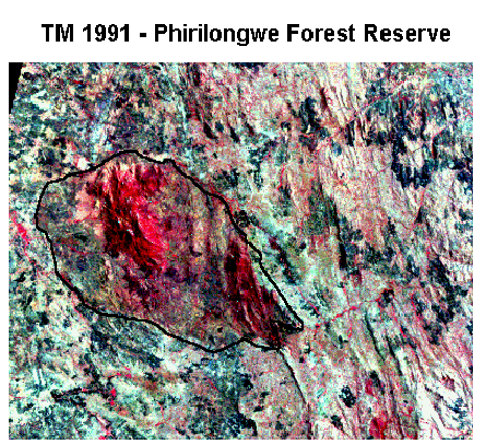 |
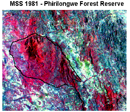 |
Figure 10: False color composite images for the two years 1981 and 1991 for the Phirilongwe Forest Reserve located in Central Malawi. The red in both images show the extent of vigorous growth from the forest cover and its significant decline over the 10 year period.
[ text]The purpose of this application was to simply illustrate the effective use of GIS and landuse mapping for decision making and project planning. The objective of the study was to evaluate the introduction of two land degradation alleviation interventions, reforestation and agroforestry. Given the rapid rates of deforestation, increasing populations and the ever increasing need for farming inputs such as fertilizers, there is a need to evaluate alternative strategies to address such issues as diminishing fuel wood supply, increased soil loss and reductions in water quality. Given the two courses of action to be evaluated, GIS can assist to identify the most suitable locations for each strategy. In order to increase fuelwood stocks, reduce soil loss, and reduce fertilizer runoff into streams, for example, decision makers have made the decision to target appropriate areas based on proximity to streams, and, the degree of slope. The table below summarizes the sample strategies. GIS can now be used to solve for these strategies and identify those areas most suited for each.
|
Near Streams (< 50 m) |
Away from Streams (> 50 m) |
|
|
Low Slopes (< 5 %) |
||
|
Moderate Slopes (5 - 9 %) |
Agroforestry (if cultivated) |
|
|
High Slopes (9 - 12 %) |
Reforestation |
Agroforestry (if cultivated) |
|
Extreme Slopes (> 12 %) |
Reforestation |
Reforestation |
The first step in the analysis is to create a landuse map. Figure 1 shows a landuse map for Kamunde catchment, one of the catchments under MEMP located in Mangochi and adjacent to the Phirilongwe Forest Reserve. The landuse map was made using image processing techniques and SPOT 20 meter satellite data. Next, using topographic data produced for the catchment by the Department of Surveys (DOS) and later digitized by Lands Resources and Conservation Branch (LRCB), a slope hazards map was produced that corresponds to the categories used in the table above (Figure 2). DOS also supplied the mapped data on the streams which were used to produce 50 meter buffers zones around each (Figure 3). Through further GIS analysis appropriate landuses were identified and evaluated using our example criteria of slopes and stream proximity and its appropriate strategy corresponding to the table above (Figure 4). Further, with the current landuse of the catchment, areas can readily be identified that are currently inappropriately employed given our strategy (Figure 5).
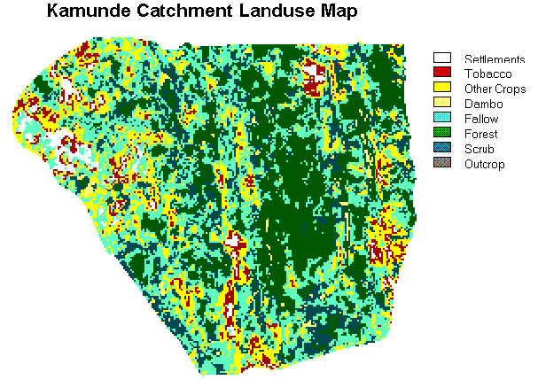 |
Figure 1: Kamunde Catchment landuse map derived from SPOT 20 meter satellite imagery.
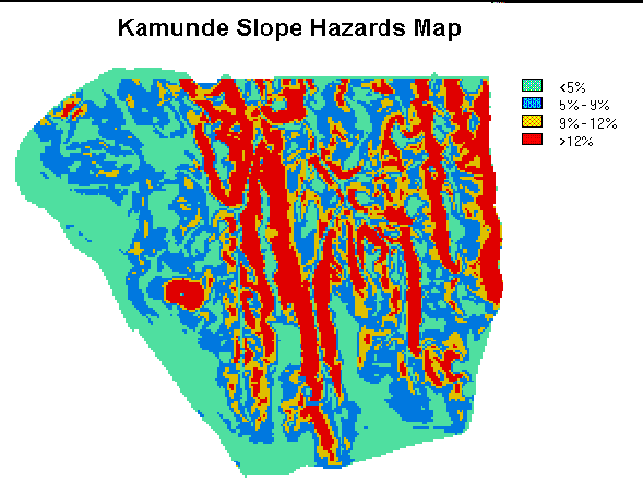 |
Figure 2: Slope hazards map derived from digital elevation model supplied by DOS.
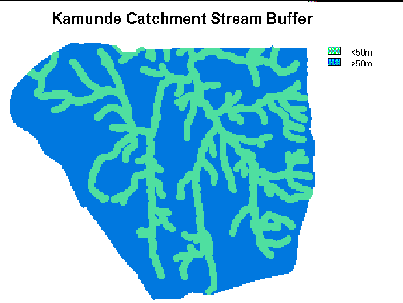 |
Figure 3: 50 meter stream buffer map.
|
Figure 4: Appropriate land allocation strategy map for reforestation or agroforestry initiatives.
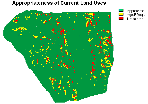 |
Figure 5: Map indicating inappropriate landuses based on proposed landuse strategies.
Appendix VI: Rainfall Mapping Using Cold Cloud Duration (CCD) Data
[ text]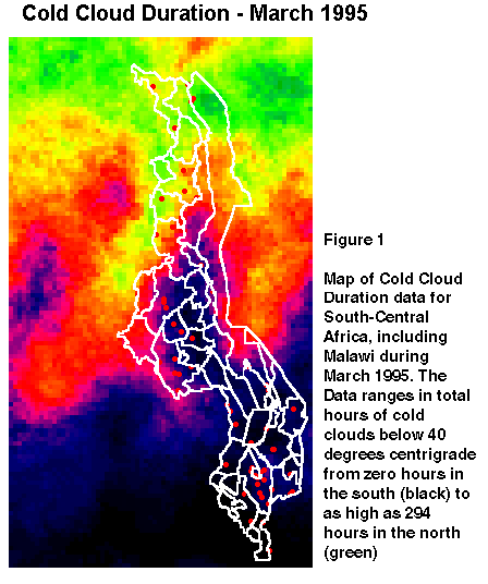 |
This application illustrates the use of Cold Cloud Duration (CCD) data from the METEOSAT satellite for the purpose of improving rainfall mapping on a timely basis. At present, the Meteorology Department creates dekadal (10-day) rainfall maps by interpolating values between rain gauge stations. These maps are essentially approximations since the interpolation procedure is simply a controlled procedure for guessing what rainfall levels would be between rainfall gauges. With the CCD data, one has a mapping of the distribution of hours under clouds with upper surface temperatures lower than 40 degrees centigrade (Figure 1). Experiments have shown these data to be highly correlated with rainfall levels. With this project, CCD data were regressed against the rainfall data for Malawi for selected rainfall reporting stations (Figure 2). A strong correlation was found, and the procedures for regular production of rainfall maps (Figure 3) using this procedure are being performed at MET. Parenthetically, it should be noted that this procedure can be used to determine direct recharge of Lake Malawi. Until now, this has been impossible because of the absence of rain gauges on the lake. It also should be noted that the Meteorology Department currently receives CCD every 10 days from the Drought Monitoring Center in Harare.
|
 |
Appendix VII: Forest Inventory Mapping
The mapping and management of Malawi's forest plantations was identified by the DOF as being vital for long-term forest management. The application project undertaken by the DOF demonstrates the use of GIS for forest inventory mapping for the Chongoni Plantation in Central Malawi. Using recent maps surveyed through traditional chain and compass and a database on the forest compartments, the plantation was digitized and imported in the GIS. The resulting maps demonstrate the database mapping capabilities of GIS for forest management.