|
|
|
MEMP Homepage |
Development of a Rapid Assessment and Monitoring Technique for Soil Erosion in Malawi Based on Analysis of the Occurrence of Broken RidgesII. Testing of a Method for Qualitative Assessment of Soil Erosion from Smallholder Farmers’ Fields in Malawi.Dr. Yusuf Mohamoud
|
A method developed to assess soil erosion occurrence and damage was tested on 30 farmers’ fields in Kamundi watershed. The method is based on establishing a relationship between the frequency and number of broken ridges and thus soil erosion occurrence and damage. Detailed discussion of the method is given in Part I of this report. Results obtained from 30 farmers’ fields in two sub-basins in the Kamundi watershed revealed that ridges broke frequently even during low intensity rainfall events. The number of times that ridges on a farmer’s field break indicates soil erosion occurrence whereas the total number of broken ridges after each rainfall event indicates soil erosion damage. High frequency of soil erosion occurrence on a farmer’s field shows that a farmer’s practice is not effectively controlling soil erosion. At Kamundi, about 30 rainfall events that produced runoff were observed during the 1997/98 rainy season and almost all of these rainfall events resulted in broken ridges. This part of the study, therefore, concludes that contour ridging used by farmers at kamundi watershed is not effective against soil erosion. In addition to the poor conservation practices, fragmented land ownership and small field sizes have also contributed to soil erosion occurrence and damage. As a result, farmers cultivating hillsides attributed soil erosion damage on their fields to runoff coming from other farmers’ fields.
In Malawi, the economic cost of soil erosion is becoming very high (World Bank, 1992) and unless remedial measures are implemented the damage caused by soil erosion may become irreversible. To control soil erosion, contour farming is the common conservation practice in Malawi. Contour farming is defined as a conservation practice where farmers plant crops on ridges that are parallel to the contour. If properly designed, contouring reduces runoff by temporarily storing excess rainfall behind ridges and thus reducing soil erosion and increasing moisture storage (Mohamoud, 1989). In spite of these benefits, when improperly designed or used on unsuitable sites, contouring causes serious soil erosion. The effectiveness of contouring depends upon the infiltration rate of the soil, design of the contour system, and slope of the area (Schwab et al.1981). On areas with low infiltration rate soils and steep slopes, water temporarily accumulated behind ridges overtops ridges often causing destruction of ridges and formation of rills and gullies.
Despite the widespread use of contour ridging in Malawi, it appears that the effectiveness of conventional contour ridging (without ties) has not been tested. Lack of testing is mainly due to lack of methods to assess soil erosion occurrence and damage. In order to understand the levels of erosion that is associated with conventional contour ridges, tied ridges and boxed ridges and make recommendations for best management practices, there is a need to develop, test and validate new methods that are suitable for assessing soil erosion from farmer’s fields. Once developed, tested and validated, the methods should be available for widespread use by researchers, conservation experts, extension workers, and farmers. The objective of this part of the study is therefore to test the method presented in Part I on 30 farmers’ fields.
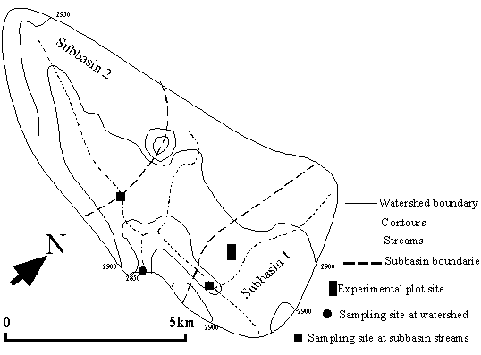
The method was tested on 30 farmers’ fields that are located at the Kmaundi watershed near Mangochi (latitude 140 33' S and longitude 350 03' E) (Figure 3). The watershed has a sandy loam soil with shallow depth and is characterized by relatively high permeability layers overlaying layers with low permeability. The watershed has an area of about 7 km2 . About 15 farmers fields located at Subbasin 1 and 15 farmers’ fields located at Subbasin 2 were used for methodology testing (Figure 3).
Testing the Rapid Assessment Technique
To learn what farmers know about soil erosion and soil and water conservation, about 30 farmers cultivating two subbasins of the Kamundi watershed were interviewed. During the interview, farmers were asked to identify the type of conservation practices that they were using, explain what they perceived as the causes of soil erosion, provide an account of the severity of soil erosion on their fields, and comment on the effectiveness of their conservation practices in controlling soil erosion. Farmers were also asked to identify the type of conservation practices that they perceive effective against soil erosion and their willingness to adopt the conservation practices that they perceived effective against soil erosion. Moreover, farmers were asked why they are not adopting the conservation practices even though they perceive it as effective against soil erosion. To verify farmers’ responses to the questions, reliability checks were made by visiting farmers’ fields and gathering information about each participating farmer’s field. Information collected during field visits included type of conservation practice, field size, field slope, ridge height, ridge orientation, and contour interval. Tables 1 and 2 of Part I list all the questions needed for the implementation of the rapid assessment technique. Testing the Monitoring Technique on farmers’ fields
To test the monitoring technique, we monitored soil erosion occurrence and damage from 30 farmers’ fields in the Kamundi watershed (Figure 3). During each rainfall event, farmers’ fields were visited and evidence of soil erosion occurrence and damage was recorded. Evidence of soil erosion occurrence was characterized by presence of broken ridges while evidence of soil erosion damage was characterized by the number of broken ridges observed after each rainfall event. Contour ridging is a common conservation practice in Kamundi watershed and the purpose of this study is to test the method by assessing soil erosion and evaluating the effectiveness of contour ridging in controlling soil erosion. Monitoring data was collected by field assistants who walked through each farmer’s field after each rainfall event, checked if ridge breakage occurred, and recorded the number of broken ridges. Because ridge breakage is caused by rainfall, field assistants also recorded the rainfall characteristics of each storm using recording rain gauges and standard manual rain gauges. Rainfall characteristics recorded after each rainfall event were rainfall depth, rainfall duration, average rainfall intensity, and maximum 30-minute intensity. Information about
soil erosion on farmers’ fields was gathered by implementing the monitoring technique as given in Table 3 of Part I.
|
|
Figure 3. Map of Malawi showing the location of the study watershed and watershed map showing the sampling sites.
Analysis of data collected under the rapid assessment technique revealed that farmers in the Kamundi area have very limited resources (land, labor, capital, skills) which often prevent them from investing in long-term conservation measures. Because of the fragmented nature of the land holdings, each farmer owns a small plots on the hillside. The average field size among the 30 participating farmers was 0.5 ha with a range of 0.14 to 0.97 ha. It is clear that farmers cannot generate adequate income from maize and tobacco grown and harvested from such small plots. Some farmers may also have other plots in nearby watersheds. The average total maize yield per farmer was about 821 kg with a range of 190 kg to 2470 kg. Farmers in the Kamundi area use very limited farm inputs. For instance, among the 30 farmers interviewed, all farmers use hand tools for construction of ridges, only 50% applied fertilizers on their gardens during the 1997/98 season, and only 3% percent used pesticides during the season.
On the average, farmers in Kamundi spend about 100 hours per year working in the field. Major activities that have high labor requirements are construction of ridges followed by weeding and reclamation of broken ridges. Because ridges break frequently, rebuilding broken ridges is a tedious work in which farmers spend considerable time. If farmers adopt better conservation practices, time spent on rebuilding broken ridges can be saved and farmers could have realized the benefits of adopting better conservation practices.
About 80 percent of the farmers responded that their ridges are aligned on the contour. Reliability checks, however, revealed the opposite and farmers seem to have difficulty in constructing ridges that are aligned on the contour. The survey also revealed that about 90 percent of the farmers burn crop residue after harvest. Farmers burn residue cover for many reasons, but the main reason is to avoid termite attack of seedlings at planting time. The fact that farmers burn residue is also an indication of their limited skills and knowledge of soil and water conservation practices.
Farmers’ perception of soil erosion and conservation practices
The survey showed that farmers are not using proper conservation practices. Majority of the farmers indicated that severe erosion which leads to rill and gully formations occur in the Kamundi watershed. Only few farmers believe that their conservation practices are effective against soil erosion. The majority of the farmers perceive rainfall, runoff, and slope as the main causes of soil erosion. They also recognize that poor management practices also contribute to soil erosion. When asked to identify what conservation practices are effective against soil erosion, farmers indicated that vetiver grass (viteveria zizanoides) and tree hedgerows are effective conservation practices. When asked why they were unable to adopt these practices, farmers responded that labor constraints and lack of financial resources are preventing them from adopting these practices.
On the average, about 30 soil erosion occurrences were reported during the 1997/98 rainy season from 30 farmers’ fields. Among these erosion occurrences, 17 percent resulted in broken ridges whereas 75 percent resulted in not only broken ridges but also serious rill and gully formations. The data also showed that more broken ridges were observed on fields with proper contour ridges than on fields with non-aligned contour ridges. When ridges are aligned on the contour, excess rainfall stored behind ridges often overtops and breaks the ridges. But when ridges are not properly aligned along the contour, excess water runs on the furrow. It appears that farmers are deliberately aligning ridges with gradients so that ridges act as runoff disposal systems such as waterways. Because runoff runs on the furrow, farmers may observe less broken ridges. Since furrows are not designed for safe disposal of runoff, serious soil erosion and gully formation occurs when farmers use ridges with gradients. Farmers may prefer ridges with gradients than ridges aligned on the contour because farmers may want to avoid the tedious work of reconstructing broken ridges that is associated with aligned ridges. Farmers in Kamundi have shown little interest to rebuild broken ridges even though they understand that unreconstructed ridges often lead to formation of gullies. About 70 percent of the farmers did not rebuild broken ridges after the rainfall event and the average farmer reconstructed broken ridges only three times during the entire rainy season.
Increased population pressure resulted in fragmentation of land ownership. Because of the fragmented land ownership, many farmers often cultivate adjacent fields on a hillside. Farmers often reach individual decisions as to what conservation practice and ridge orientation to use. As observed in the Kamundi watershed, runoff from one farmer’s field often passes through another farmer’s field located at the lower part of the hillside and creates severe soil erosion. Since farmers have no system for safe disposal of runoff such as grassed waterways, furrows often act as runoff disposal systems particularly when farmers’ ridges have haphazard alignment. Once runoff starts somewhere at the upper parts of a hillside, regardless of the effectiveness of individual farmer’s conservation practices, ridge breakage occurs due to concentrated flow from uphill. About 50 percent of the farmers whose fields are located at Subbasin 1 and 20 percent of the farmers whose fields are located at Subbasin 2 indicated that runoff from other farmers’ fields caused soil erosion to occur on their fields.
Farmers’ fields have small sizes and one farmer’s field is often located next to another farmer’s field. There are small property boundaries called footpaths where farmers use to access their plots. Continuous walking particularly when the soil is wet creates soil compaction along the footpaths. In most cases, footpaths generate surface runoff which often leads to gully formation due to concentrated flow passing downwards along footpaths. Because footpaths are on common boundaries, farmers do not usually maintain when gullies form on footpaths. In some cases, all the loose soil particles erode and deep gullies form. As the gully depth reaches the bare rock, gullies become stabilized and act as permanent waterways.
An effective conservation practice must minimize or avoid occurrence of runoff by either enhancing the infiltration capacity of the soil or increasing the surface depression storage on the soil surface. Most of the accelerated soil erosion occurring in Malawi can be mitigated if measures that can enhance infiltration and surface depression storage are adopted. Based on results obtained from Kamundi watershed, the following recommendations can be made.
A method developed to assess soil erosion occurrence was tested on 30 farmers’ fields. On the average, about 30 soil erosion occurrences were recorded out of about 50 rainfall events on each farmer’s field during the 1997/1998 season. Considering the number of rainfall events that produced runoff, this is a very high frequency. It means that ridges on farmers’ fields got broken almost every rainfall event that produced runoff. If ridges break very often, farmers’ conservation practices are not effective against soil erosion. Results of the methodology testing in Kamundi showed that farmers’ conservation practices were not effectively controlling soil erosion and serious soil erosion has occurred during 1997/98 rainy season.
FAO. 1987. Soil and water conservation in semi-arid areas. FAO Soils Bulletin. Paper 57. FAO, Rome.
Mohamoud, Y.M., Ewing, L.K., Mitchell, J.K, 1990. Small Plot Hydrology: II Tillage System and Row Direction Effects. Transactions of the ASAE. Vol (4) pp. 1132-1140.
Schwab, O.G, Frevert, R.K. , Edminster, T.W, and Barnes, K. K., 1981. Soil and Water Conservation Engineering. 3rd eds. John Wiley and Sons. New York pp.525
World Bank. 1992. Malawi Economic Report on Environmental Policy. World Bank, Lilongwe, Malawi.