Introduction to the Physical and Biogeography of the Sawtooth Mountains
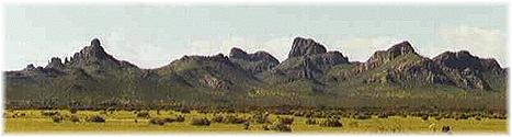
The Sawtooth Mountains of south-central Arizona are located 32 degrees 34'-32 degrees 40' N latitude and 111 degrees 42'-111 degrees 46' W longitude. The range, about 6 miles in length and about 5 miles wide, occupies R6E, T9-10S (Gila Meridian and Baseline), approximately 12 miles southwest of Eloy, Pinal County, Arizona. The central portion of the range is owned by the Bureau of Land Management, while the surrounding bajada is State Trust Land; collection occurred in both of these areas.
Rising to 800 m (2630 ft) above sea level, the Sawtooth Mountains are surrounded by otherwise bajada-like to flat alluvial or sandy terrain at or below 490 m (1600 ft) in elevation. Greene Wash runs along the northeastern limit of the range and drains to the broad Santa Cruz Valley to the north. At least one major groundwater depletion-associated subsidence crack occurs in the area of this survey, and several others occur on the flats to the east of the Sawtooth Mountains. Anastomosing major and minor ephemeral washes drain the plains to the south and west of the range, coalescing to a playa at one point and extending northward along the axis of the Tat Momoli Valley, this hydrologically isolated from the Santa Cruz Valley by a shallow divide south of Wildcat Peak at the south end of the range.
The Sawtooth Mountains are igneous in origin. Undifferentiated and of mostly intermediate (but including rhyolitic and basaltic) composition, aphanitic to porphyritic or vesicular rocks and breccias of these rocks form the high cliffs, rocky slopes, gravels, and alluvial or colluvial substrates available to vegetation. The eastern side of the range is flanked by a broad bajada extending from the foothills at about 520 m (1700') elevation to Greene Wash and its tributaries at about 480 m (1570') elevation. Several major, dry washes originate in the foothills and cross the bajada as more or less entrenched channels. Irrigated agriculture occupies land east and north of Greene Wash, while the flats to the southeast and south are under livestock grazing. Eolian sand forms flats and vegetated mounds at the southern end of the range with the sediment source probably the playa to the south and the washes that drain into it.
Biogeographically, the Sawtooth Mountain range proper is placed in the Arizona Upland subdivision, while the area immediately surrounding the Sawtooth Mountains falls within the Lower Colorado River Valley (LCRV) subdivision of the Sonoran Desertscrub biome as defined by Turner and Brown (1982). The Arizona Upland subdivision "is on slopes, broken ground, and multi-dissected sloping plains" (Turner & Brown, 1982:200) and vegetation comprises woody leguminous trees interspersed with shrubs and cacti. The bordering LCRV subdivision is characterized by a combination of low precipitation and high temperature, resulting in vegetation communities that are "typically both open and simple, reflecting the intense competition existing between plants for the scarce water source" (Turner & Brown, 1982:190).
Meteorological data from a station in Eloy indicates a wintertime average temperature of 11.5 degrees C and 65 mm winter precipitation; a summertime average temperature of 30.5 degrees C and 75 mm summer precipitation; the average overall annual precipitation at 214.6 mm (Turner & Brown, 1982). Data from the Arizona Meteorological Network (AZMET) station at Eloy, Arizona, indicates an average temperature of 13.2 degrees C and total precipitation at 205 mm for the period December 1997 through May 1998; the averages for these months for the years 1989-1997 are 15.5 degrees C and 116 mm total precipitation. Qualitatively, the 1997-1998 field season was the coolest and the third wettest of the years 1989-1998.