| The Maricopa Environmental Monitoring Site
Strategies for measuring field infiltration
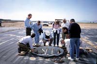
When water enters the soil surface, it descends through the vadose, or unsaturated zone, where it dissolves soluble minerals and carries them in solution down to the water table. If contaminants are present they will be swept along as well. These may include pesticides in agricultural fields, or solid wastes at federal dump sites; either way, they eventually will reach the ground water, affecting water quality. Monitoring systems can help track the movement of these substances. "If you have a landfill or disposal site, you'd like to know what's going on underneath the soil surface," says Peter Wierenga, head of the Department of Soil, Water and Environmental Science at The University of Arizona. "Are there chemicals leaching into the ground water? To find that out you need instruments under the disposal site to measure what's going on." Wierenga has tested four different strategies for monitoring water and chemicals as they pass through the vadose zone. Working with soil scientist Arthur Warrick, research scientist Michael Young, data technician Sherry Musil, and a group of graduate and post-doctoral students, he set up a series of experiments on a one-acre plot at the College of Agriculture's Maricopa Agricultural Center. Their research was funded by the Nuclear Regulatory Commission in Washington D.C. Wierenga says the NRC was interested because they plan to decommission some of the facilities where nuclear materials were used or produced. The waste these facilities have produced must be stored, and the subsoil around the storage areas monitored. "At the ag center we designed a field site that simulates what you might have in the real world, but on a smaller scale," Wierenga says. The test area consisted of bare ground criss- crossed with a very dense surface drip system set up in a 30 x 30 cm grid for applying water and selected tracking chemicals. The water table lies 35 feet below. Heavy-duty plastic pond liner covered the ground. "That way, we'd know that all the water we applied went into the ground, with nothing escaping into the air," Wierenga says. For the first strategy, a trench five feet deep was dug across the length of the plot and fitted with instrumentation placed along the trench wall. The second method featured a highway culvert sunk vertically into a hole ten feet deep and five feet wide. At various intervals down the length of the culvert, soil measurement instruments were installed through the wall into the undisturbed soil. In the more conventional third strategy, instruments were placed at different depths into six-inch diameter bore-holes scattered across the plot. The holes were then backfilled to the soil surface. For the fourth system, geophysical techniques measured water movement from the soil surface all the way to the water table. These techniques included electromagnetic induction methods, and cross-bore-hole tomography, an intricate and sophisticated technique that measured electrical resistance between boreholes at different intervals. A computer model was then used to resolve how deep the water had penetrated. For the first three systems, the following instruments were used: neutron probes, tensiometers, heat dissipation sensors and suction lysimeters, (to extract a small volume of water from the soil for analysis). The researchers also took measurements of the ground water concentration. Most of the instruments worked as the researchers had suspected they would. The water moved down as expected, also, but as it moved into deeper layers the scientists found that water movement became more uniform. However, where they had a leak water would move more rapidly. "If you do have leaks, there's no doubt that the water will be carried to the ground water much faster," Wierenga says. "We simulated a slow leak, but were not able to simulate something like a tank bursting." To track chemical movements, he used bromide, an innocuous chemical. All of this instrumentation generated intensive amounts of data. Wierenga found that the neutron probe gave good data for many practical situations. He especially liked the horizontal neutron probe access tube installation. In this case, the access tube is laid in the bottom of a trench (as for the first strategy), the trench is filled, and the probe is pulled through the access tube with a long cable. "This appears to be a pretty good technique under landfills," he says. "It is a very straightforward method of measurement for long-term observation." The method does involve labor at the outset but is low maintenance after that. And Wierenga notes that although the neutron probe gives accurate, reliable readings, they must be taken manually. On the other hand, tensiometers and heat dissipation sensors are fully automatic, but they sample a smaller volume of soil than the neutron probes. Tensiometers work only in moist soil and require more maintenance. As for the geophysical method, it looks promising, according to Wierenga, but it needs more study. He says the tomography would be one of the best methods for long-term monitoring but the computer analysis needed to interpret the data needs to be refined. To explain the techniques they used in the study, Wierenga and his associates conducted two technology transfer meetings at the site in 1998 and another in Washington D.C. Targeted toward people from different federal and state agencies, participants included representatives from the EPA, Department of Energy (DOE), the NRC and the Agricultural Research Service (ARS). The sessions at the agricultural center were designed to be practical. "We spent a whole day explaining our project, how we did it and what our results were," Wierenga says. "Some of the participants got to take measurements themselves. It was a little more hands-on." Article Written by Susan McGinley, ECAT, College
of Agriculture Researcher:
|