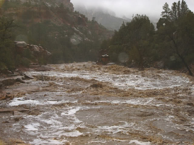
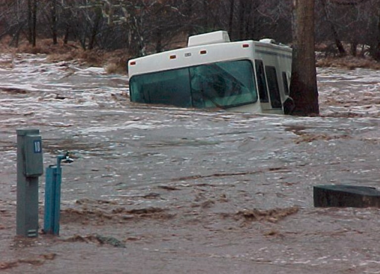
 Flood Preparedness - October 8, 2014 Jeff Schalau, Agent, Agriculture & Natural Resources University of Arizona Cooperative Extension, Yavapai County Arizona has had its share of floods this summer, but over time, our memories tend to fade and we forget what can happen. We certainly remember the Slide Fire near Oak Creek that burned in May and June of this year? This was a fairly recent event. How about the floods along Oak Creek in 2004/05 and 2009? Well, maybe these events have begun to fade from our collective memories. We spend lots of time discussing drought, so much so that we may forget to think about flooding. This is especially important in areas where impervious surfaces dominate the landscape. If exposed rock and/or extensive paved areas are upstream, heavy precipitation has little opportunity to soak in. This effect is amplified when vegetation is removed by fire. The time to think about flooding is now (actually all the time), but there are many things we can do to mitigate flood effects. I don’t live along Oak Creek, but I’ve seen the photos of the December 29, 2004 flood. It was an impressive event caused by rain falling on snow and many people sustained property losses. My home is along Miller Creek in Prescott where this same storm system caused flooding and took away lots of soil and eroded away a large portion of my concrete low water crossing. Further downstream from my house, two young men lost their lives as they tried to navigate Granite Creek in a canoe. There was also a more recent flood in Sedona in September 2009 that washed several cars downstream near Tlaquepaque. Streamside (and arroyo-side) property owners can take steps to minimize soil losses by increasing bank stability. Grasses, sedges, and rushes have fibrous root system to hold the soil and lie flat when water flows over them. These are the best plant species to hold the soil. Trees and shrubs slow the flow of water, but can also create debris dams that can alter stream flow patterns. Allowing streams to meander dissipates energy and slows soil losses from banks. Rocks, from cobbles to boulders, can also dissipate the energy of flowing water. Artificial structures are sometimes used to slow streamside erosion and prevent gully formation. These structures include fabrics, sandbags, check dams, straw bales and wattles, etc. Culverts, concrete, and channelization all increase the velocity and concentrate the energy of flowing water. Yavapai County Flood Control District (YCFCD) encourages residents and visitors to be alert and aware of the conditions during our monsoon season and during winter, especially when a cold winter storm is followed by a warm winter storm which can result in rain falling on and melting snow. Keep informed via radio, television, the internet, NOAA weather radio, and through the Yavapai County Emergency Management Regional Alert website. If you own a mobile phone with text capabilities, you should already be receiving flood/severe storm warning messages. YCFCD’s recommendations follow. Never attempt to drive through water on a road. Water can be deeper than it appears, and water levels can rise very quickly. Know the elevation of your property in relation to nearby streams and other waterways. Make advance plans of what you will do and where you will go in a flash flood emergency (Yavapai County Government now has the 100 year floodplains mapped and available on-line). Listen to area radio or television stations and NOAA weather radio. Be prepared to move out of danger’s way. If you are on the road, watch for flooding at highway dips, bridges, and low areas. Stay away from natural streambeds, arroyos, and other drainage channels during and after rainstorms and watch for signs of distant heavy rainfall. Keep children away from floodwaters near culverts and storm drains. Protect property with sand bags, relocate or elevate items of personal or economic value. Disconnect and/or move equipment and appliances. Be especially cautious at night when it is harder to recognize flood dangers. The suggestions above may seem too simple, but each time a flood occurs we hear about someone that had a close call, was injured, or worse. Below I have included additional information, including photos and a video, to remind you what can happen. Follow the Backyard Gardener on Twitter – use the link on the BYG website. If you have other gardening questions, call the Master Gardener help line in the Camp Verde office at 928-554-8999 Ext. 3 or e-mail us at verdevalleymg@gmail.com and be sure to include your name, address and phone number. Find past Backyard Gardener columns or provide feedback at the Backyard Gardener web site: http://cals.arizona.edu/yavapai/anr/hort/byg/. Additional Resources Yavapai County Flood Control District Website This site has many resources including weather data, Realtime precipitation data for all remote station in their system, information about flood insurance and more. www.ycflood.com/ Yavapai County Geographic Information Systems (GIS) Floodplain Map This interactive mapping application shows various floodplain designations across Yavapai County. gis.yavapai.us/Flood/FloodHaz.aspx 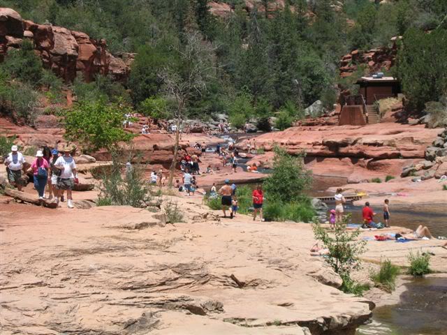
 |