|
|
|
MEMP Homepage |
An Overview of the Malawi Environmental Monitoring Programmes’ Small Catchment Monitoring Component
with Recommendations to Meet Malawi’s National Environmental Monitoring Requirements
Prepared by
|
The following report was prepared as part of the technical assistance programme provided to the Government of Malawi through support of USAID by the University of Arizona and Clark Univeristy. This report summarizes the findings from the Malawi Environmental Monitoring Programme’s Small Catchment Monitoring Component for the years covering 1995 through 1997. A number of lessons have been learned during this period which this report tries to capture through recommendations on appropriate modifications to assist the GoM in meeting its statutory national environmental monitoring requirements as described in the Environmental Management Act (GOM, 1996).
The report is divided into two parts. The first part provides an overview of the MEMP as it was developed and subsequently modified to try to monitor the impact of policy reform to allow smallholder farmers to cultivate burley tobacco. During this three year period data was collected from four catchments. Assessment of the appropriateness of this data to describe the impact of smallholder production on the environment reveals that of the four catchments, only two; Kamundi and Chilindamaji have data of suitable quality to interpret findings. Unfortunately, of these two, there is an insufficient number of observations for the key parameters to directly assess whether there has been any impact which could be attributed to burley tobacco production. The ability to make statements concerning the impact of burley tobacco production is further limited in that of these two catchments, only the Kamundi catchment has shown an increase in the number of farmers growing burley tobacco.
Part two of the report attempts to move forward from the objectives of the first phase of the MEMP to those of the second phase in demonstrating a methodology suitable for monitoring of wider environmental issues as outlined in the National Environmental Action Plan. This part of the report illustrates how the experiences gained in small catchment monitoring can be applied to other areas in Malawi. It specifically seeks to build on a major weakness of the first phase where there was no clear link between monitoring and mitigation to develop monitoring linkages with other conservation of national significance such as the Malawi Agroforestry Extension Program and PROSCARP.
The modifications proposed in the second part of the report are being implement on a trial basis during the 1997/98 growing season under the technical supervision of the Environmental Science Advisor. The results of this trial will be available at a later date.
PART ONE: AN OVERVIEW TO MEMP SMALL CATCHMENT MONITORING ACTIVITIES
Following the reform of policy in Malawi allowing for the liberalization of tobacco production, it was envisaged that cultivation by smallholder farmers will increase by either shifting from maize-based cultivation to tobacco-based cultivation or by introducing new land under tobacco cultivation. It was also well understood that increased tobacco cultivation by smallholder farmers could accelerate the trends of land degradation in Malawi. Major environmental problems that are associated with tobacco cultivation include: increased soil erosion and water resources degradation, and deforestation.
Farmers often improve the quality of the tobacco leaves by applying the recommended doses of fertilizers and pesticides. These chemical inputs are often carried by runoff which can ultimately contribute to the water resources degradation such as eutrophication of rivers and lakes.
Soil erosion may increase due to increased tobacco cultivation because the crop has less canopy cover and thus provides less protection of the soil surface from raindrop impact. Furthermore, with tobacco cultivation, very little residue is left on the ground after harvest which may also result in increased soil erosion and siltation of lakes. This report focuses on the impact of the tobacco liberalization policy on the degradation of soil and water resources.
The purpose of the small catchment monitoring program during the first phase of MEMP was to monitor the impact of burley tobacco liberalization policy on the environment by assessing the policy impact on soil and water resources degradation, and deforestation. The methodology used to test the impact is based on monitoring water quality, and land use and forest cover changes at four small catchments. On each catchment, environmental data is collected at the field level (e.g., control plots and farmers' plots) and at the catchment level. To study the effect of crop type (tobacco) on non-point source pollution, three control plots (experimental plots) and several field plots (farmers' plots) were established at four small catchments in Malawi. The treatments selected for the control plots were maize and tobacco-planted on contour ridges, and an unweeded fallow plot. The procedure used to test the relationship between crop type (tobacco) and non-point source pollution is to measure runoff, nutrient loss, sediment loss, and pesticide data from each plot and to statistically analyze if results from the tobacco grown plot are significantly different from the results obtained from the maize or fallow plot.
In addition to control plot data, efforts to monitor catchment-wide impacts of increased tobacco cultivation were made. This was done by collecting water samples from farmers' plots, groundwater wells, and streams at each catchment's outlet. Although data from these sources can provide information useful for understanding the levels of land degradation occurring in the watershed, other than the control plot data, information obtained from these data sources may not be directly linked to the impact of burley tobacco cultivation on the environment. If increases of land area under tobacco cultivation and increases in chemical applications due to tobacco cultivation are known, it would have been possible to link these increases to changes in pesticide and nutrient concentrations in stream waters at the catchment outlet. But, catchment-wide data on increases of tobacco cultivation and increases of chemical applications are not available.
The objectives of this report are two-fold. The first objective is to examine the quality of the data collected from the MEMP small catchments during 1994/95, 1995/96, and 1996/97 rainy seasons. The second objective is to present this report as reference material for training purposes. The report is particularly useful for demonstrating the importance data quality on data analysis, interpretation and reporting.
Environmental data collected from the four MEMP catchments include: rainfall, runoff, and water quality (e.g., suspended sediments, nutrients and pesticides). Trained farmers and field assistants collect data from different sources within each catchment and forward it to the agency or agencies responsible for data analysis, interpretation, and reporting. The Meteorological Department is responsible for the analysis, interpretation, and reporting of rainfall data. The department uses a network of standard rain gauges to record daily rainfall depth over each catchment and a recording gauge to measure rainfall intensity, depth and duration of each storm.
There are several sites in each catchment where runoff data is measured. In each catchment, runoff is measured from three control plots, farmers' plots, and streams at the catchment outlet. Runoff depth data measured from control and farmers' plots is sent to the Land Resources and Conservation Department of the Ministry of Agriculture and Irrigation for quality control, analysis, interpretation, and reporting. The Water Resources Department is responsible for recording streamflow data at the catchment outlet. Streamflow data is measured using staff gauges and automatic water level recorders.
In addition to rainfall, runoff, and streamflow data, water samples are also collected from plots, groundwater wells, and streams at the catchment outlet. The samples are taken to the Central Water Laboratory for water quality analysis (e.g., nutrients and suspended sediments). Some aliquots of water samples are forwarded by the Central Water Laboratory to the Malawi Bureau of Standards for pesticide analysis. To estimate the amount of soil nutrients lost by each plot during each rainfall event, sediment samples collected from pits at control plots and farmers' plots are analyzed for nutrient concentrations by the Chitedze Agricultural Research Center. Table 1 gives information on data types and sources as well as list of MEMP participating agencies that are responsible for data analysis and reporting.
|
Data type |
Data source |
Agency Responsible for Data Analysis |
Agency or Institutions Responsible for Reporting |
|
Rainfall (depth-duration-intensity) |
Catchment |
Meteorology Department |
Meteorology Department |
|
Runoff (Streamflow) |
Catchment
|
Water Resources Branch |
Water Resources Branch |
|
Runoff depth |
Field plots |
Land Resources and Conservation Branch |
Land Resources and Conservation Branch |
|
Control plots |
|||
|
Soil nutrients on the sediments (N, C, P, K, Mg, Ca) |
Field plots and Control plots |
Chitedze agricultural research station |
Land Resources and Conservation Branch |
|
Pesticide (no |
Streams |
Malawi Bureau of Standards |
Water Resources Branch |
|
pesticide data |
Field plots |
||
|
analyzed ) except |
Control plots |
||
|
1994/1995 season |
Wells |
||
|
Water quality variables (pH, TDS, SO4 , NO3 , PO4, Na, K, and sediments) |
Streams |
Central Water Department Laboratory |
Ministry of Environmental Affairs and Research |
|
Field plots |
|||
|
Control plots |
|||
|
Wells |
|||
|
Calibartion of the Soil Erosion Estimator for Southern Africa (SLEMSA) |
Control plots and farmers’ field plots |
Land Resources and Conservation Branch
|
Land Resources and Conservation Branch |
|
Land use Change |
catchment |
Forestry Department |
Forestry Department |
|
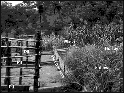
Control plots are three adjacent plots that receive different treatments every year. On an annual rotational basis, three plots receive maize, tobacco and fallow treatments. Both the tobacco grown and maize grown plots are freshly tilled with contour ridges, but the fallow plot has no fresh tillage or newly constructed contour ridges. Unlike farmers' plots, control plots have borders that are made of either galvanized iron sheets or concrete. Because of its fixed boundaries, control plots can be considered as "micro-catchments" where runoff entering the pit is generated only within the plot boundary. Figure 1 illustrates iron sheet plot borders, pits, and crops grown on control plots at Chilindamaji. As illustrated in Figure 1, the three control plots have three different treatments that are aimed at evaluating the effect of crop type on nutrient, pesticide, and sediment loss. |
|
|
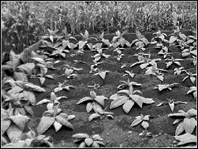
Importance of the Control Plot Data Data from the control plots have two important uses. First, the data is useful for testing the hypothesis that burley tobacco cultivation increases runoff, sediment and nutrient loss. Because of the ease in quantifying runoff, sediment and nutrient loss, control plots play a fundamental role in providing data that can be used for testing whether, compared to maize and fallow, plots where tobacco was grown have higher sediment, nutrient, and pesticide concentrations. If all other sources of variations are controlled, data from the control plot treatments may explain if tobacco planted plots have significantly higher chemical and sediment concentrations than other plots. Second, data from the control plots can be useful for calibrating and validating soil erosion models such as Soil Loss Estimator For Southern Africa (SLEMSA) (Elwell, 1978) and Universal Soil Loss Equation (USLE) (Wischmeier et al. 1978). In Malawi, numerical soil loss data that is suitable for calibrating SLEMSA and USLE is not available. Data from some of the control plots may therefore be used for calibrating the SLEMSA and USLE models. Quality of the Control Plot Data The design layout and the treatments on the control plots are suitable for testing the hypothesis that increased tobacco cultivation increases pesticide, nutrient, and sediment. However, the degree of confidence in testing this hypothesis depends upon the quality of the data. Preliminary analysis show that the quality of the MEMP data varies from catchment to catchment and with the skills and experience of field assistants and data collectors. It appears that data from control plots at Kamundi and Chilindamaji catchments may be suitable for further analysis and interpretation. Data from the Chulu and Njolomole control plots is not however suitable for any meaningful analysis and interpretation and reporting. One of the factors affecting the quality of the control plot data from Chulu and Njolomole is that the distance between the plot location and automatic raingauge location is more than 10 kilometers. Because of spatial variability in rainfall depth, it may not be accurate to use rainfall intensity data from these automatic rainfall recorders when estimating rainfall erosivity for the Universal Soil Loss Equation (USLE) (Wishmeier et al. 1978). In addition to their location relative to the location of the recording raingauges, data control plots in Chulu and Njolomole was either not available or had serious errors that impair its usefulness for any meaningful analysis. The control plot data has number of limitations that affect its suitability for evaluating the effect of increased burley tobacco cultivation on the environment. These limitations are mainly lack of uniformity between treatments (controlling all sources of variations) and rotation of the crops between plots. During a field visit on February 1997, it was observed that some control plots have different conservation practices. For example, the tobacco grown control plot shown in Figure 2 has box ridges while the adjacent maize grown plot has contour ridges. Unless all plots have standard and uniform land management practices, differences between land management practices among plots confound the effect of crop type by introducing other sources of variations. |
|
|
Even if runoff, sediment, pesticide, and nutrient concentrations from the tobacco grown plots are significantly higher than those measured from plots where tobacco was not grown, it is difficult to conclude that these differences are due to differences in crop type. Where plots have different types of ridges, ridge heights, and ridge intervals, differences between runoff, soil loss and nutrient loss cannot be linked to crop type only. Without controlling other sources of variations such control practices, it is extremely difficult to establish any relationship between the tobacco crop and pollution. Plots where higher amounts of chemical inputs are applied are expected to have water and soil samples with high nutrient and pesticide concentrations. The three treatments are rotated annually and tobacco is grown on a different plot each year. Assuming that each crop uses different amounts and types of fertilizers and pesticides, annual crop rotation ensures unnecessary mixing that all plots receive similar chemical inputs at different years. Some of these chemical inputs have residual effect and can remain in the soil for several years. Despite limited amount of pesticide applications by farmers in Chilindamji, the 1994 MEMP report indicated that high concentrations of pesticides were obtained from water samples collected from plots and streams. Some of the pesticide concentrations exceeded the WHO standards. It appears that these pesticides can remain in the soil for years. Therefore, with crop rotation, linking pollution levels measured from a plot to the crop grown on the plot during that year may be confounded by pesticides or fertilizers applied to the plot during the previous season. A better approach might have been to continuously grow tobacco on the same plot. Such an experimental design would take into account any build up of residuals in the soil and could be useful for understanding the future trends of soil and nutrient loss as influenced by crop type and its associated chemical inputs. The control plot data also has limitations that affect its suitability for calibrating soil erosion models. To calibrate the SLEMSA model, soil loss data measured from the plots are often compared with soil loss data predicted by the model. However, adequate water samples were not analyzed for suspended sediments during 1995/96 rainy season and thus the data collected from the control plots is not suitable for SLEMSA model calibration. The control plot data has also some limitations that affect the calibration of models such as Universal Soil Loss Equation (USLE). As Slack (1996) pointed out, among the four catchments, only the Chilindamaji catchment has a recording rain gauge that is located near the plot. The recording rain gauge at Kamundi is located within an acceptable distance from the plots but recording rain gauge locations at Chulu and Njolomole are far from the control plot sites. Since recording rain gauges measure rainfall intensity, lack of rainfall intensity data excludes the calibration of the USLE model. Interpretations of Preliminary Results From the Control Plots A preliminary examination of the 1995/96 data from selected plots does not show any significant differences in sediments and nutrients measured from the tobacco grown plot and maize-planted plot. For normal growth and development, different crops require different amounts of chemical inputs. We can assume that crops that use increased chemical inputs such as tobacco will have increased non-point source pollution since only a small fraction of the chemical inputs applied to a plot is carried by runoff and sediments. Although the tobacco crop requires higher chemical applications, actual chemical input used is often subject to the availability of financial resources to purchase fertilizers and pesticides. For smallholder farmers in Malawi, the assumption that increased tobacco cultivation will cause increased pollution may not be valid since farmers are often unable to purchase the recommended chemical inputs for the tobacco crop. Walker(1996) reported on the socio-economic aspects of the farmers in all four catchments. Further discussion on the socio-economic aspects of the farmers is not the focus of this report. This assumption could have been valid for estate farmers who can afford to purchase the required chemical inputs for the tobacco crop. Preliminary results reported by Mkandwire (1997) show that the amount of soil loss predicted by the SLEMSA model is 10 times less than that measured from the plots. Discrepancies between measured and predicted soil loss rates may be due to problems caused by the quality of the data measured from the plots or due to limitations of the SLEMSA model for predicting soil loss under Malawian conditions. A major limitation of the SLEMSA model is that the model is not suitable for predicting soil loss rates from fields that have contour ridges which is a common control practice in Malawi. The discrepancies observed by Mkandawire (1997) may as well be due to the fact that the model is not applicable to contour ridging and therefore, in its present form, is not suitable for the conditions in Malawi. To explain the causes of these discrepancies, accurate data should be collected from the control plots so that the SLEMSA model can be calibrated and validated for the conditions in Malawi. Data collected from the control plots during 1995/96 is inadequate for SLEMSA calibration. The procedure for obtaining seasonal soil loss values requires continuous collection of sediments after each runoff producing rainfall event. Sediments measured from each plot after each runoff producing rainfall is summed together to get a seasonal soil loss value from each plot. Unfortunately, during 1995/96 rainy season, a limited number of samples were analyzed for suspended sediments. Considering only storms greater than 10 mm, these catchments often receive about 50 storms that produce runoff and sediment. Out of these 50 storms, depending on the catchment, only a limited number of samples were analyzed for suspended sediments. Clearly, it is inaccurate to assume that sediment data obtained from five days out of 50 runoff producing rainfall days can represent the amount of sediment lost by a plot. As shown by Mkandawire (1997), in order to calibrate and validate the SLEMSA and USLE models, adequate and accurate soil loss data is needed. Farmers' plot Layout and Treatments Farmers' plots are small plots that are selected at different locations within each catchment. Initially, there were about six farmers' plots in each catchment. But, based on Slack's (1996) recommendations, the number of farmers plots have been reduced and each catchment now has about three farmers' plots where data is collected. The main purpose of using farmer's plots is not to study the impact of burley tobacco on the environment but to study the average levels of sediments and nutrient loss that is occurring in farmers' fields. Farmers' plots selected for monitoring may not represent all the management practices and management levels that exist within each catchment. The design layout on farmers' plots is different from those commonly found on farmers' fields in the catchment. Because of the way farmers' plots were designed, data collected from farmers' plots may not provide an average level of runoff and soil erosion rates over each catchment. The rationale behind the choice of the design layout in farmers' plots and what can be learned from these plots is given below. Slack (1996) reported that control plots have contour ridges while farmers' plots have ridges with up-and-down slope orientation. During a field visit in February-March, 1997, it was also observed that the control plots and farmers's plots have different design layouts. Farmers' plots have row orientations that range from properly designed contour ridges with zero gradient to poorly designed contour ridges with gradients up to 90 degrees. In most cases, both control and farmers' plots have contour ridges, but the location of the pit is what makes the two plots different (Figure 3). Farmers' plot pits are placed parallel to the ridges and therefore drain sideways without breaking ridges while control plot pits are perpendicular to the contour ridges and therefore runoff entering the pit either breaks the ridges or overtops the ridges. Such a difference in plot layout creates two different control practices and thus results in differences in runoff and sediment loss from the plots. These differences do not, however, suggest a flaw in the design. It was a deliberate attempt that was aimed at studying the amount of runoff and sediment loss that is associated with the farmers' plot layout (Mkandawire, 1997). The ridge orientation in farmers' plots represents the type of ridges that are made by farmers who are unable to design contour ridges properly. Importance of Farmers' Plot Data If accurately monitored, farmer's plots can demonstrate the effect of properly designed contour ridges in reducing or controlling runoff and soil erosion. Imam (1996) compared runoff from control plots and runoff from farmers' plots in the Chilindamaji catchment. He concluded that control plots had less runoff than farmers' plots. The differences in runoff and soil loss between the plots can be easily linked to the difference between the control practices. Because of their ridge orientation, control plots can store excess rainfall (rainfall more than infiltration) as surface depression storage and therefore release less runoff. On the other hand, because many farmers' plots have no proper contour ridges to store excess rainfall as surface depression storage, all rainfall in excess of infiltration is released as runoff. Data from farmers' plots have two main problems that affect its suitability for any meaningful analysis, interpretation, and reporting. First, runoff measured from some of the farmers' plots exceed rainfall. Second, due to lack of well-defined plot boundaries, runoff generated by rain falling outside the plot enters the pits and is counted as if it is coming from the plot. Runoff from cultivated lands must always be less than rainfall since all the rainfall is not available to produce runoff. Some of the rainfall is intercepted by crop canopy or vegetation, some infiltrates into the soil, and some portion of the rainfall is stored as surface depression storage. Therefore, runoff can be nearly equal to rainfall only when infiltration, interception, and surface depression storage are equal to zero. On cultivated lands, runoff can only exceed rainfall if errors are made when recording either the runoff depth or the rainfall depth. For example, to ensure that runoff measured in the pit corresponds to a given storm, data collectors often record the runoff and empty the pit of the runoff and sediment. The reason for doing this is to link each rainfall to its runoff and sediment. However, when data collectors forget to empty the pit, runoff accumulates in the pit. Without realizing the runoff accumulation, data collectors may record the runoff twice and count it as if it was caused by the rainfall that fell only during the second day. When runoff and rainfall are not measured at the same location, discrepancies between rainfall and runoff can be observed. For most of the catchments, runoff is measured at the pit but, in most cases, rainfall is measured by a rain gauge which is not located adjacent to the plot. Depending on the distance between the two locations, spatial variability of rainfall may cause slight discrepancies between rainfall and runoff. Errors made by data collectors are responsible for runoff to exceed rainfall but to lesser extent spatial variability of rainfall between the rain gauge location and plot location may be responsible for runoff exceeding rainfall. Table 2 gives the number of times runoff exceeded rainfall for each plot during 1994/95, 1995/96, and 1996/97 season. Clearly, the number of times runoff exceeded rainfall had declined over the years. This may be an indication that the quality of the data is improving. |
|
Catchment |
Plot number |
YEAR |
||
|
1994/95 |
1995/96 |
1996/97 |
||
|
Chilindamaji |
CHI 1 |
6 |
1 |
NA |
|
CHI 2 |
33 |
5 |
NA |
|
|
CHI 3 |
24 |
12 |
NA |
|
|
CHI 4 |
15 |
6 |
NA |
|
|
Chulu |
CHU 1 |
NA |
0 |
0 |
|
CHU 2 |
NA |
0 |
0 |
|
|
CHU 3 |
NA |
6 |
8 |
|
|
Kamundi |
KAM 1 |
NA |
1 |
NA |
|
KAM 2 |
NA |
3 |
0 |
|
|
KAM 3 |
NA |
11 |
6 |
|
|
KAM 4 |
NA |
1 |
4 |
|
|
KAM 6 |
NA |
2 |
NA |
|
|
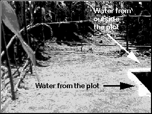
Runoff can also exceed rainfall if the runoff generated by rainfall that falls outside the plot boundaries enters the pit as occurs when plots have no fixed and well-maintained boundaries. Unlike control plots where plots have galvanized iron sheet or concrete borders, farmers' plots have no fixed boundaries that define the plot as a "micro-catchment" where runoff measured in the pit comes only within the plot boundaries and not from outside the plot. Farmer's plots are designed to have ridges as plot boundaries. For instance, all three farmers plots in Njolomole where data is still actively collected have no borders. Two out of the three farmers plots in Kamundi also have similar problems while the third plot has very small border ridges which could easily break during heavy rainstorms. Similarly, most of the farmers' plots at Chulu and Chilindamaji have no fixed plot boundaries. Because of lack of well-maintained border ridges, it is likely that water coming from outside the plot enters the pits (Figure 4). The design capacity of these pits corresponds to runoff generated within the plot boundaries and the pits would overflow if runoff coming outside the plot enters the pit.. Without knowing the exact area of each plot that is contributing runoff to the pit, the data from the farmers' plots may not be very useful. |
|
|
As more forested land is cleared for tobacco cultivation and more farmers shift from maize-based cultivation to tobacco-based cultivation, changes in water yield and water quality from these catchments were expected. The importance of the streamflow data was to measure these changes and when possible to relate the changes to changes in land use and vegetation cover. Other than documenting changes due to tobacco cultivation, the streamflow data is also useful for determining how the soil, geology, topography, and rainfall characteristics influence runoff and soil erosion. Depending on the soils, geology, and topography of the catchment, streamflow measurement can also provide some insights into the dominant runoff mechanism and hence some indication of the vulnerability of the catchment to soil erosion. Furthermore, streamflow flow data is important for determining the catchment water yield and sediment yield as influenced by land use/ land management practices. Quality of the Streamflow Data Streamflow measurements are made at selected stream cross sections at each catchment's outlet. All four streams have staff gauges and three out of the four streams have automatic water level recorders. Despite being well-equiped, streamflow data measured from some of these streams is not very accurate. These inaccuracies are caused by unstable stream cross sections that are frequently changing due to streambank and streambed erosion or siltation. Two out of the four stream gauging stations are seriously affected by streambank erosion and siltation. Serious streambank erosion has changed the course of the Linkhuwe River near Njolomole to the extent that the staff gauge placed at the middle of the stream is no longer useful since the channel has shifted away from the initial gauge location. Similarly, the staff gauge placed at the middle section of the Mchenda River near Chulu has been completely buried by sediments. In both rivers, unless rating curves were continuously updated, streamflow data from these streams is not reliable. The Nematokhokwe River near Kamundi has had slight problems caused by flash floods that often wash away staff gauges. Without a staff gauge, no streamflow data is recorded when the staff gauge is washed away. Because of its stable cross-sections, streamflow data measured from the Kalwe River near Chilindamaji is reliable. Streambank or streambed erosion or siltation at the stream cross-sections where the stream gauge measurements are made often result in changes that are unpredictable. Such changes alter the relationships between water depth measured at the stream and stream discharge. These relationships are often known as rating curves and are established by frequent measurements between the depth and discharge of a cross-section area-velocity method. The validity of a rating curve is subject to the stability of the cross-sectional area of the river and any changes in river cross-sections due to streambank or streambed erosion or siltation can introduce errors in the streamflow measurement. These errors can be avoided only if the rating curves are continuously updated-a task that requires frequent field visits. Importance of Groundwater Quality Data for Environmental Monitoring The importance of groundwater quality data is to determine the amount of nutrients, particularly nitrates that are reaching the groundwater. Because these catchments are located on customary lands where farmers use less amounts of fertilizers, the nitrate concentrations obtained in groundwater is low and may not pose any serious health hazards. In addition, due to the diffused nature of chemical transport in the porous media, it is difficult to link changes in groundwater quality to the tobacco liberalization policy. Therefore, continued monitoring of water quality samples from groundwater wells may not be important. Quality of the Laboratory Data Analysis Water samples collected from control plots, farmers' plots, streams, and wells are sent to the Central Water Laboratory for suspended sediment, chemical, and pesticide analysis. Because the Central Water Laboratory has no capability in analyzing pesticides, some aliquots from the water samples are forwarded to the Malawi Bureau of Standards for pesticide analysis. The Central Water Laboratory analyzes the rest of the water samples for suspended sediments, total dissolved solids, pH, nitrate, sulphate, phosphate, sodium, and potassium. In addition to the water samples, sediment samples collected from the pits are also analyzed for plant nutrients by the Soil Laboratory at Chitedze Agricultural Research Station. The nutrients analyzed from each sample are: pH, organic matter, nitrogen, phosphorus, potassium, calcium and magnesium. Table 3 shows the number of samples analyzed by the two laboratories for water quality and soil nutrients. Table 3 shows that data was collected only from the Chilindamaji catchment. A comparison between the number of samples analyzed during 1995/96 and 1997/98 reveals that the data collection and laboratory data analysis had improved. More samples have been analyzed during 1996/97 than any other year. The accuracy and reliability of the laboratory data is not known. It is however known that samples often remain in the laboratory for a long period of time before samples are analyzed. Some parameters such as pH should have not been analyzed in the Laboratory and when necessary should have been analyzed only at the field. For other parameters, a shorter period of holding time, proper storage facilities, and the use of preservatives are highly recommended. |
|
CATCHMENT |
PLOT # |
YEAR |
||||||||||||
|
1994/95 |
1995/96 |
1996/97 |
||||||||||||
|
Water (WQ) quality |
Soil nutrient (SN) |
W Q |
S N |
W Q |
S N |
|||||||||
|
KAMUNDI |
1 |
22 |
4 |
4 |
1 |
|||||||||
|
2 |
15 |
3 |
12 |
22 |
||||||||||
|
3 |
24 |
3 |
12 |
22 |
||||||||||
|
4 |
22 |
5 |
9 |
22 |
||||||||||
|
6 |
22 |
6 |
9 |
1 |
||||||||||
|
B |
20 |
3 |
4 |
14 |
||||||||||
|
F |
21 |
3 |
3 |
14 |
||||||||||
|
M |
24 |
4 |
4 |
16 |
||||||||||
|
CHILINDAMAJI |
1 |
25 |
15 |
7 |
3 |
1 |
||||||||
|
2 |
35 |
30 |
7 |
3 |
||||||||||
|
3 |
38 |
25 |
7 |
2 |
22 |
|||||||||
|
4 |
28 |
24 |
5 |
5 |
||||||||||
|
B |
19 |
15 |
3 |
0 |
42 |
|||||||||
|
F |
15 |
12 |
- |
- |
19 |
|||||||||
|
M |
21 |
15 |
7 |
0 |
22 |
|||||||||
|
CHULU |
1 |
23 |
17 |
22 |
7 |
|||||||||
|
2 |
25 |
16 |
22 |
20 |
||||||||||
|
3 |
21 |
16 |
15 |
1 |
||||||||||
|
There were some concerns about the large number of samples coming to the Central Water Laboratory for chemical analysis and the lack of adequate laboratory facilities and skilled staff who can cope with increased demand for chemical analaysis. Because of these concerns, MEMP provided a consultant who made some recommendations and presented some solutions to some outstanding technical difficulties. Slack (1996) noted that a large number of samples are sent for laboratory analysis and made two recommendations. First, he recommended that the number farmers plots where samples are collected should be reduced. Secondly, he recommended that samples should be collected only when rainfall is equal or greater than 10 mm. In spite of recommendations made by Slack (1996), it appears that the problem was not the number of samples coming to the Central Water Laboratory but actually the limited number of samples analyzed during 1994/95, 1995/96 and 1996/97 rainy season (Table 3). The number of samples analyzed for some of the parameters is not adequate for reaching a conclusion about the impact of the burley tobacco liberalization policy. To achieve the objectives of MEMP I, the environmental data collected from these catchments must provide information that reflect both the characteristics of the sites (baseline data) and the temporal variations of the parameters as affected by land use/ and management practices. A preliminary analysis of the data reveals that some parameters should not have been frequentlty analyzed since these parameters remain almost constant through out the rainy season. It was not necessary to continuously analyze parameters that have low variability through out the rainy season. These parameters include sodium, calcium, potassium, and magnesium. On the other hand, the amount of suspended sediment collected from plots and streams appears to have high variability and is a key parameter in understanding soil erosion rates from the catchment. The number of samples analyzed for suspended sediment is therefore not adequate for understanding the soil erosion rates from the catchment and any average sediment value obtained from these samples underestimates the actual soil loss (Table 3). In addition to reducing the number of samples analyzed as recommended by Slack (1996), it is also important to reduce the number of parameters analyzed from each sample. A review of the data collected from the MEMP catchments reveals that the number of samples analyzed for suspended sediments was insufficient. Data Analysis, Interpretation and Reporting Although environmental data has been collected from four MEMP catchments for the last three years, the data analysis and interpretation efforts do not match the data collection efforts. Lack of data analysis and interpretation has caused continued data collection without any critical evaluation of adequacy, accuracy, and reliability of the data. There are several factors that have contributed to the delayed-effort in analyzing, interpreting and reporting the data from the catchments. First, because of the quantitative nature of the runoff, sediment and nutrient data, an in-depth knowledge of the subject matter is a prerequisite for analysis of environmental data. Second, as Slack (1996) pointed out, the environmental data has a research orientation. It is this research orientation that makes it difficulty for staff from MEMP particpating agencies to deal with research data which is beyond their daily activities and experience. Another factor that greatly contributed to these shortcomings is the sectoral nature of the activities of MEMP participating agencies and the lack of inter-agency collaboration between agencies. As part of the MEMP activities, each MEMP participating agency prepares a sectoral report that summarizes the environmental issues that are relevant to the agency's activities and that can be obtained from data collected from the MEMP catchments. When preparing the sectoral reports, each agency uses its data when available and there is very limited effort to cooperate on data sharing between agencies. Lack of inter-agency cooperation and data sharing activities is a major limitation to the quality of the sectoral reports. For example, the Water Resources Department collects streamflow data and prepares a report only on streamflow while the Meteorological Department collects rainfall data and prepares a report only on rainfall data. Environmental data analysis requires multi-disciplinary and teamwork approach but the structure of the agencies and the skills of the people who work for the MEMP participating agencies are often only focused to sectoral issues. Unless better links are established between agencies and teamwork approach is adopted, environmental data analysis may continue to be a serious problem for MEMP participating agencies. It is the responsibility of each MEMP participating agency to prepare a sectoral report based on the data collected by the agency. Without complete and well presented sectoral reports the task of preparing a synthesis report is often complicated. This has been a serious shortcoming that made it impossible for the core committee to produce the synthesis report. Some of these shortcomings were due to lack of commitment, lack of skills to analyze and interpret the data which affected the quality of the sectoral reports and consequently the quality of the synthesis report. In an attempt to facilitate data analysis and interpretation of environmental data, Slack (1996) recommended that research and monitoring components should be distinguished and training on data analysis and interpretation be offered to staff from MEMP participating agencies. Conclusion The following conclusions emerge from the MEMP Small Catchment monitoring
The following recommendations are made for the MEMP small catchment monitoring activities:
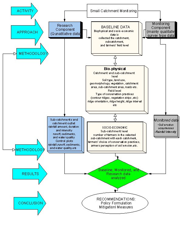
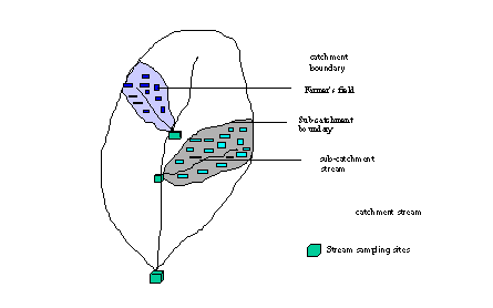
PART TWO: A METHODOLOGY FOR MONITORING AND EVALUATING SOIL EROSION RATES FROM SMALL CATCHMENTS An effective catchment environmental monitoring program must monitor the major environmental problems in Malawi (e.g., soil erosion, deforestation, and water resources degradation). The Malawi National Environmental Action Plan (NEAP) (DREA, 1994) listed nine environmental problems and ranked soil erosion as the number environmental problem. Soil erosion is a serious problem due to both on-site impacts such as loss of soil fertility and consequent reduction in crop yields, and off-site impacts such as degradation of surface water bodies with loss of reservoir storage capacity and consequently loss of hydro-electric power generation capacity. The amount of soil erosion from a catchment depends on number of factors, but human activities that influence land use and land management are often responsible for the accelerated soil erosion (Green, 1996). In Malawi, over 85 percent of the population live in rural areas where agriculture provides both income and employment (Kapila et al. 1995). Therefore soil erosion and loss of soil fertility and consequently reduction in crop yield are threatening to livelihoods of the rural population. In the past, shifting cultivation has been the traditional solution to declining soil fertility. However, due to increased population pressure on the land, there is very little suitable land left for shifting to take place. Any additional shifting would lead to cultivation of marginal lands with serious soil erosion potential. Even where possible, fallow periods are short and may not warrant sufficient soil organic matter build up. Soil fertility can be temporarily increased by using inorganic fertilizers. But, intense use of inorganic fertilizers cannot offer a long term solution to the problem of soil erosion and loss of soil fertility and is often too expensive for smallholder farmers at the current market prices. Furthermore, unless soil erosion is controlled, any chemical inputs including inorganic fertilizers that farmers use will be transported to rivers and lakes by runoff. Sediment and nutrient lost by farmers’ fields constitute loss of soil fertility at the field level and serious pollutants elsewhere particularly rivers and reservoirs. Increased non-point source from farmlands causes eutrophication and degradation of delicate aquatic ecosystems (USEPA, 1984). Lakes are particularly vulnerable to eutrophication which occurs when lake water becomes enriched with nutrients that damage the balance of the ecosystem by causing excessive growth of vegetation commonly known as algal blum. As plants die, bacteria decomposes the organic matter and the biological oxygen demand (BOD) needed for decomposition increases. The rise in BOD from decomposition depletes the oxygen and organisms become suffocated. Without oxygen the ecosystem would hardly support life and many species of fish that are important to fishing communities may be lost forever. In addition to the eutrophication problem, sediments have undesirable effects to reservoirs as sediments trapped by reservoirs cause loss of storage capacity. Depending on the design of the reservoir and the objectives under which it was originally constructed, excessive sedimentation can cause serious economic loss and environmental damage over a short period. Reservoirs in the Shire River Basin are already experiencing serious siltation problems which adversely affect their capacity to generate hydroelectric power in a sustainable manner. The main objective of the second phase of the Malawi Environmental Monitoring Program (MEMP II) under NATURE is to increase the sustainable use, conservation, and management of Malawi’s renewable natural resources. Specific objectives of MEMP II include enhancing the technical and the scientific capacity of the country’s human resources so as to support the development of sustainable natural resources management. To achieve MEMP II objectives, the current catchment monitoring activity will need to shift from studying the environmental impacts of burley tobacco liberalization policy to understanding the impact of land use type and land management practices on soil and water resources degradation. A revised catchment monitoring strategy is necessary which focuses on both on-site and off-site impacts of soil erosion as it affects two important resources; soil and water. Conceptual Framework of a Catchment Monitoring Program Since soil erosion poses serious environmental problems both at the site where soil is detached (on-site) and where it is deposited (off-site), catchment monitoring should effectively address non-point source pollution particularly sediment and nutrient loss from small catchments. To achieve MEMP II objectives, a conceptual framework for catchment monitoring is presented (Figure 4). The framework is based on recommendations made by Slack (1996) which emphasizes the need for distinguishing the current monitoring activities into research and monitoring components. The monitoring component will consist of baseline and monitored data from the catchment, sub-catchment, and field level while the research component will consist of measuring quantitative data such as runoff and water quality from control plots and streams at the sub-catchments and catchment outlets. Although the emphasis of the monitoring is obtain bio-physical data, socio-economic data concerning farmers levels of income and farmers’ perception of soil erosion and soil conservation will be gathered. |
|
|
To estimate the magnitude of soil erosion rates from farmers fields, small plots with different land management practices that closely resemble farmers’ land management practices are often used. In developed countries, it is relatively easy to translate information obtained from small plots to larger areas because of the dominance of large scale mechanized agriculture where one farmer owns and manages large portion of a sub-catchment and where a single land management practice is uniformly applied all over the field. However, in developing countries such as Malawi, large number of farmers often share a piece of land each cultivating an area that ranges between 0.5 ha to 2 hectares (Kapila et al. 1995). Because of the fragmented land ownership and differences in farmers’ choice of conservation practices, different levels of land management practices are often used by farmers cultivating adjacent fields. Because of these differences, it is difficult to represent all management practices that exist in the catchment and to translate results obtained from small plot experiments to smallholder farmers with diversified conservation practices. Any attempt to monitor the amount of soil and nutrient loss from farmers fields should take into account the differences in farmers’ land management practices. Therefore, while measuring the amount of nutrient and soil loss from farmers’ fields, it is important to understand the differences between management practices among farmers and to develop ways to identify the erosion damage that is associated with each management practice. For instance, runoff generated by a field with poor land management practices often passes through fields located downslope and results in severe soil erosion and gully formation. Once runoff starts somewhere in the hillslope, regardless of the effectiveness of farmers’ land management practices, it is unlikely that farmers’ practices can withstand concentrated flows. As a result, ridges will be broken and soil erosion and gully formation will occur when concentrated flows from uphill pass through fields located downslope. Unless similar management practices and levels are adopted collectively by all farmers cultivating the same area, despite positive individual farmers’ efforts, soil erosion will continue to occur. By distinguishing the research and monitoring components, the complexity in the data collection activity is reduced. For example, despite the collection of large number of samples for laboratory analysis, the adequacy and reliability of some of the data may not warrant any meaningful interpretation of the results. Therefore, to avoid these problems, the monitoring component will deal only with qualitative data which will be collected by field assistants and farmers from selected sites in the catchment. An important feature of the monitoring component is that it does not require intensive quantitative data collection and laboratory data analysis. The main objectives of the monitoring component are:
There is a widespread belief in the country that soil erosion is occurring at an alarming rate. But, numerical data to confirm that serious soil erosion is occurring is not available. Much speculation has occurred but little concrete evidence has been presented to prove the amount of soil erosion that is occurring under different land use patterns. In reality, the degree of soil erosion in Malawi is based on personal opinion and observations of severely eroded hillslopes, sediment laden rivers, and silted lakes, and reservoirs. The Bvumbwe Soil Erosion Research presents results on soil erosion rates from small catchments with different land uses. The results of the study show that the catchment with the least conservation practices had a tolerable soil loss level while those with better conservation practices or forest cover had negligible amount of soil loss (Amphlett, 1986). The soil loss data presented in their final report, however, indicates that sediment data has not been collected during all rainy days that produced runoff and sediments. To fill the missing gaps in the sediment data, an empirical relationship between sediment and runoff was developed and used to estimate sediments during days when sediment data was not available. There are some problems that need to be considered while conducting research on soil erosion. First, the data should be accurate and reliable so that what is measured at the site is what is occurring at the site. Secondly, because it is expensive to set up experiments and measure soil loss from several sites in order to understand the amount of soil loss, methods to transfer data measured from a site to other sites are needed. Furthermore, research on soil erosion should focus on both on-site and off-site soil erosion impacts. As an example of this concept, detailed studies at the plot level would provide information on relative erosion rates from plots that have different conservation practices, while monitoring at the sub-catchment and catchment level would provide useful information for determining a sediment delivery ratio that can explain the soil erosion dynamics and the amount of sediments coming from the upland (e.g; control plots) that are not reaching streams at the catchment outlet. Therefore, by setting up experimental plots (e.g., control plots) with land management practices that are similar to those used by the majority of the farmers, the amount of erosion and soil loss that is associated with particular types of management practices can be evaluated. In Malawi conditions, because of differences between farmers’ land management practices, it is more important to understand the amount of nutrient and sediment load coming from sub-catchments where several farmers’ fields are located than estimating sediment from individual farmer’s fields. Under the revised catchment monitoring, quantitative data such as nutrient and sediment loss will not be collected from pits in farmers’ fields. But information on the levels of soil erosion rates that collectively occurred during a given rainfall event will be derived from the number of broken ridges and sediment loads measured from sub-catchment streams that drain farmers’ fields. As noted in part one, the quality of the data often determines its use and unless it is improved, some of the data collected from the catchments may not be useful for modelling purposes. Reliable prediction of soil loss by mathematical models such as Soil Loss Estimation Model for Southern Africa (SLEMSA) (Elwell, 1977), Universal Soil Loss Equation (USLE) (Wischmeier and Smith, 1978), Water Erosion Prediction Project (WEPP) (Nearing et al. 1989), and Erosion Productivity Impact Calculator (EPIC) (Williams et al. 1983) require adequate and accurate field data. Once models are calibrated and validated using good quality data, the models can be used as a conservation planning tool. Models are, therefore, important tools that can facilitate the extrapolation of the results from the monitoring and reduce the need for continuous monitoring and data collection. The objectives of the research component are as follows:
Advantages of the Revised Catchment Monitoring In Malawi, compared to other land uses, cultivated lands particularly those with poor land management practices often contribute to the increased soil erosion and siltation of lakes and reservoirs (DREA, 1994). The focus of the revised catchment monitoring is to quantify soil loss from control plots, evaluate the effectiveness of farmers’ practices in controlling soil erosion, and estimate sediment yields from small catchments. In addition to the collection of accurate and reliable, the advantage of the revised monitoring is to introduce the use of models as tools for extrapolating the results obtained from monitoring and research components of the revised catchment monitoring. Some of the advantages of the revised catchment monitoring include: reducing the complexities in the data collection by distinguishing the research and monitoring components; improving the accuracy, adequacy, and reliability of the data; and introducing the use of models as tools for extrapolating results from these catchment to unmonitored catchments. Table 4 gives a comparison between the current monitoring and the revised catchment monitoring. |
|
CURRENT MONITORING |
REVISED MONITORING |
|
Main emphasis on environmental impact of burley tobacco liberalization policy |
Main emphasis on monitoring and evaluating the impact of land use/ and management practices on soil and water resources degradation |
|
No distinction between research and monitoring was made |
Distinction between research and monitoring is being made |
|
Data was collected from control plots, farmers’ plots, wells, and streams of all four catchments |
Data is collected from control plots and streams of two catchment namely Kamundi and Chilindamaji |
|
No emphasis on baseline data collection |
Strong emphasis on baseline data for catchment characterization and for extrapolation of the results to non-monitored catchments |
|
Farmers and field assistants collect the data |
Field assistants and Bunda College students will collect the data |
|
Effectiveness of the conservation practices currently used by the majority of the farmers cannot be tested |
Effectiveness of farmers’ management practices will be tested |
|
Erosion occurring other than selected farmers’ plots is not known |
Information on erosion is gathered from 30 farmers’ fields in each catchment |
|
Not suitable for GIS presentation |
Suitable for GIS presentation |
|
Models were not used for extrapolation of results to unmonitored catchments |
Models will be used for extrapolation of site specific results to unmonitored catchments. |
|
Data collection under the monitoring component consist of baseline data and monitored data. The baseline data will be collected at the sub-catchment and field levels. The baseline data collection activity will start before the monitoring data. Unlike the baseline data collection, monitored data will be collected from farmers’ fields during all rainy days throughout the rainy season. The data collection under the research component will consist of data from control plots and data from streams draining the sub-catchments and the catchment (Figure 5). Detailed methods of data collection under the monitoring and research components are given below. |
|
|
The monitoring component under the revised catchment monitoring is aimed at estimating the erosion hazard of a sub-catchment as influenced by factors governing soil erosion. As given in the Universal Soil Loss Equation (USLE), these factors are soil erosivity, soil erodibility, slope steepness, slope length, cropping management and control practices. Some of these factors such as slope steepness, slope length, and soil erodibility have slow temporal variability and may not change over the rainy season. Information about these factors will be gathered as baseline data. However, factors such as rainfall erosivity, cropping management and control practices change during the rainy season and information about these factors will be gathered either as baseline or monitored data. Other than the temporal scale, the data will be collected at spatial scales within a catchment: field, sub-catchment, and catchment level (Figure 5). Baseline Data Collection at the Sub-Catchment At the sub-catchment level, information about soil, climate, topography, and land use will be collected. To characterize the soils of the two catchments and to understand their potential for soil erosion, soil characteristics such as soil texture, soil depth, cation exchange capacity, hydraulic conductivity will be measured. Soil erodibility factors will be determined from soil properties. Rainfall erosivity factors will also be determined from the rainfall characteristics of each catchment. Geomorphological characteristics such as drainage density, stream frequency, longitudinal slope, and cross-sectional slopes will be determined using 1:50,000 scale topographic maps of the catchment. Other important baseline data include the land use patterns and vegetation cover of each catchment. Geographic information system will be used to quantify the land use and vegetation cover classes of each catchment. When adequate baseline data is collected and each catchment is characterized, it may be possible to answer questions raised about the representativeness of the MEMP catchments by simply matching catchment characteristics with characteristics of unmonitored catchments in Malawi. Baseline Data Collection at the Field Level At the field level, information about land management practices, farmer’s management levels, and farmers’ perception on the causes of soil erosion will be monitored. Baseline data will include information on the location of the field in the sub-catchment, area of the field, slope, type of conservation practices-contour ridges, contour interval, and ridge height. Baseline data is important not only to establish a criteria under which future environmental changes can be measured but is also important to demonstrate the susceptibility of a catchment to soil erosion and to facilitate the selection of suitable mitigation measures. Other than soil, topography, and climatic data, baseline data consists of information gathered from farmers’ fields. Some of the baseline data is similar to that collected from the Machinga ADD under the Area Sample Frame (ASF). Table 5 gives baseline data to be collected from farmers’ fields. |
|
ITEMS |
FARMER’S NAME |
FIELD NUMBER |
|
1. Are soil and water conservation practices (SWC) present on this field? <y=yes, n=no> |
|
|
|
2. If yes, which: 1) properly designed contour ridges (zero gradient), 2) Improperly designed ridges on gradient, 3) vetiver hedgerows (approximate interval) 4) tree or alley hedgerows |
|
|
|
3. If ridges present, what is slope along ridges? |
|
|
|
4. If yes, contour interval in centimerters |
|
|
|
5. Is there residue at planting? y, n |
|
|
|
6. If no ridges what is the slope of the field? |
|
|
|
7. % of field covered by SWC measures, |
|
|
|
8. Do SWC measures appear to be effective? |
|
|
|
9. Is there evidence of soil erosion? <y=yes, n=no> |
|
|
|
10. If yes, type of erosion. 1. Sheet, 2. gully, 3. gully on footpaths. |
|
|
|
11. If gullies present, how many? |
|
|
|
12. Evidence of reclamation efforts? <y=yes, n=no> |
|
|
|
13. If yes, which 1) raised footpaths, 2) check dams 3) grass, 4) banana, 5) combination, 6) ridges on contour ridges tied at gully, footpath or boundary, other |
|
|
|
14. What happens to crop residue? 1. burn, 2. bury, 3. Feed livestock, 4. Leave on field, 5. Fuel |
|
|
|
15. Are footpaths present? <y=yes, n=no> Where located? 1) field, 2) field boundary What is orientation? 1) up & down, 2) contour |
|
|
|
Causes of soil erosion |
Kamundi |
Chilindamaji |
|
|
Heavy rain |
|||
|
Bare soil or lack of cover |
|||
|
Steep slopes |
|||
|
Farming methods |
|||
|
Cutting trees and plants |
|||
|
Not leaving residue cover |
|||
|
Running water from other fields |
|
||
|
USEFUL MANAGEMENT PRACTICES |
|||
|
Time spent on making conservation practices |
|
|
|
|
What do you think are the best two soil conservation practices? |
|
|
|
|
Are you currently using any of these practices? Yes; No if No why? |
|
|
|
|
WHY NOT CONSERVE SOIL? |
|||
|
No erosion hazard |
|||
|
Not useful |
|||
|
Money |
|||
|
Labor |
|||
|
Other |
|||
|
Monitored Data At The Field Level The purpose of monitoring farmers’ fields is to evaluate the effectiveness of the land management practices currently used by the farmers. Before making recommendations for new conservation practices or improving the traditional practices, it is appropriate to characterize the expected levels of soil erosion rates that can occur under different soil, topography, and rainfall regime; and to monitor how farmers are coping with the risk of soil erosion on each catchment. The methodology used in this study is based on the selection of participating farmers whose fields will be continuously monitored throughout the rainy season. In each catchment, a total of 30 farmers will participate in the monitoring activities. About 15 farmers will be selected from each sub-catchment. Unlike the baseline data, the monitored data which consists of information on frequency of soil erosion occurrence and extent of soil erosion will be gathered during each rainy day. Table 6 gives the data type to be monitored from farmers’ fields. Soil erosion occurrence is characterized by evidence of runoff or flowing water, or occurrence of sheet, rill or gully erosion and/or evidence of broken ridges, or presence of surface changes that can be attributed to the preceding rainfall event. The number of broken ridges or rill formations in a field imply the severity of the storm. To link the erosion damage to the characteristics of the rainfall event, a recording rain gauge will be placed at each sub-catchment. Field assistants will visit farmers’ fields and will gather information on any changes that occurred in the field at the end of each rainfall event. By monitoring farmers’ fields, an analysis of the frequency of soil erosion occurrence can reveal some insights on the relative importance of the factors influencing soil erosion. This information will be used to evaluate the effect of rainfall, soil type, slope, crop, and cropping management and control practices on farmers’ fields by recording the number of times erosion occurs in the field. To make meaningful analysis and to understand why severe erosion occurs at some farmers fields and not in other farmers fields, baseline data will be analyzed in conjunction with monitored data. Analysis of these two data sets can explain the factors that lead to frequent erosion occurrence in farmers fields. The data to be monitored from farmers’ fields is given in Table 7. |
|
Date: |
Farmer’s name: |
Field No. |
||
|
Rainfall Characteristics (nearest gauge) |
depth |
duration |
Intensity |
|
|
Does soil erosion occurred today |
yes |
no |
other remarks |
|
|
Type of erosion and extent of soil erosion damage (circle one) |
Category I: No ridges were broken but runoff was generated |
Category II : Ridges broken but no rill and gully formation |
Category III : visible rills or gullies |
|
|
Causes of the erosion (circle one) |
rainfall only |
runoff from the farmer’s field |
runoff coming from other farmers’ field(s) |
|
|
What type of conservation practices are found in the area where erosion occurred? |
Write the type of conservation practice |
no conservation practices |
other remarks |
|
|
Evidence of broken ridges |
number of ridges broken |
number of times such incidence occurred in the past |
other remarks |
|
|
normal rare |
||||
|
Evidence of reclamation efforts |
rebuilt by the farmer after the rainfall event |
waited until the next rainfall event |
remained the same after several events |
|
|
Yes No |
yes no |
yes no |
||
|
Presence of other changes on the surface |
||||
|
Crop type and cultivar |
||||
|
Crop height |
||||
|
Crop yield |
||||
|
Other comments |
|
|||
|
Under the research component, data will be collected at three sampling sites: control plots, streams at the sub-catchment outlet and catchment outlet. A detailed discussion of the methodology used for data collection is given below. During the 1997/98 rainy season, runoff and sediment data will be collected from control plots at Kamundi and Chilindamaji catchments. The data collected from the control plots may undergo only very slight changes from what has been collected during the previous growing seasons. Under the revised catchment monitoring, the plots will be modified so that data collected will be suitable for calibrating the SLEMSA model for the conditions in Malawi. These changes are aimed at improving the accuracy and reliability of the data so that the objectives of the research component can be achieved. All six control plots will receive uniform and standardized treatments. Recommended treatments for each set of plots at both sites are : bare and weeded plot with no-till, bare and no-till with 50% residue cover, and maize crop planted on tilled soil with contour ridges. Data collection activities will start at the onset of the rainy season and will continue throughout the season. However, data will be collected from the control plots only during rainy season and only when runoff producing rainfall event occurs. Under the revised catchment monitoring, control plots should be considered as experimental research plots where accurate and reliable data is collected for calibrating soil erosion models such as the SLEMSA model for the conditions in Malawi. As part of capacity building, two students from the Agricultural Engineering Department of Bunda College, will participate in the data collection activities from November to December. One student will be working at Kamundi and the other at Chilindamji. The title of their research project is: " Comparisons of SLEMSA and USLE Models for the Conditions in Malawi". As shown in Figure 5, there are a number of sampling sites at the sub-catchment and catchment outlets. The frequency of sampling at the sub-catchment streams will depend on the storm and the amount of sediment in the stream. Water samples will be collected only when severe erosion is observed at farmers’ fields and when the turbidity of the water at the sub-catchment stream is high. Because these sub-catchments drain the portion of the catchment where participating farmers’ fields are located, suspended sediment measured at the stream reflects the amount of soil loss from farmers’ fields. In the past, to understand the amount of sediment from farmers’ fields, sediment samples were collected from pits in farmers’ fields. However, under the revised catchment monitoring sediment and nutrient data will not be collected from farmers’ fields. Sediment and nutrient samples collected from streams that drain the sub-catchment where farmers’ fields are located can provide information on the amount sediment and nutrients coming from farmers’ fields. The frequency of sediment sampling at the catchment outlet will depend on the flood event or water level at the stream. Suspended sediment samples are manually collected at sub-catchment and catchment streams at Kamundi and Chilindamaji. Water samples collected from streams will be taken to the laboratory for sediment and nutrient analysis. To preserve the physical and chemical composition of the samples, the data will be transported from the field to the laboratory as quickly as possible. In cases when laboratory analysis cannot be done immediately, to avoid water quality changes, acid preservatives will be added to the samples if necessary. The parameters to be analysed from each sample are similar to those measured in the past. But the frequency and intensity of sampling will change. In addition, this research will put more emphasis on sediment and nutrient parameters and less emphasis on ionic water quality. For instance, some of the additional parameters will include total nitrogen, total phosphorus, total organic phosphorus, total organic nitrogen and total ammonium and total organic carbon. When possible sediment and nutrient discharges from the catchments will be calculated using the sediment and nutrient concentrations and streamflow data measured at the catchment outlet. [ Table of Contents]The methodology presented here is now under testing at Kamundi and Chilindamaji. Preliminary results obtained from these two catchments show that the current management practices used by farmers in these catchments are not effective in controlling soil erosion. Which would lead to consideration of how the MEMP may assist farmers by providing linkages to mitigation programs designed to provide better conservation practices such as vetiver grass and tree hedge rows as currently available through PROSCARP. These technologies can be made available to the farmers by MAFE. If all partners agree, we can demonstrate the impact of the these technology within a very short time - within the next rainy season. Data collected during this season will be used as a baseline which represents unmitigated condition and will be compared with data obtained after mitigation measures are in place. The Area Sample Frame provides a quick and cost effective means of obtaining data from farmers fields but lacks the detail needed to understand how information obtained can influence some of the environmental issues such as soil erosion. There is a need to link information obtained from the qualitative data from 60 farmers to information obtained from the Area Sample Frame. Because it is expensive to conduct intensive monitoring, developing ways to link the two methodologies in such way that the information obtained by intensive monitoring can be linked to information obtained from the Area Sample Frame and data from the intensive monitoring can be extrapolated to large areas. [ Table of Contents]Amphlett, M.B. 1986. Soil Erosion Research Project, Bvumbwe, Hydraulics Research, Report OD78, Wallingford, U.K. DREA. 1994. Malawi National Environmental Action Plan. Department of Research and Environmental Affairs, Lilongwe, Malawi. Elwell, H.A. 1978. Soil Loss Estimation: Compiled works of Rhodesian Multi-disciplinary team on Soil Loss Estimation. Department of conservation and Extension. Causeway, Rhodesia. August, 1978. 145p. Elwell, H.A. 1977. A soil loss estimation system for Southern Africa. Research Bulletin No.22 Causeway (Zimbabwe): Department of Conservation and Extension Imam, B. 1996. Report for field guidelines, Department of Hydrology and water resources, University of Arizona, Kapilla, M.L.M. and Mwafongo, W.M.K. 11995. Status of soil degradation in Malawi. A paper presented at the SADC regional workshop on soil erosion and degradation, monitoring methodies and techniques, Harare, Zimbabwe, 4-&th December, 1995. Mkandawire, V. 1997. Rainfall, runoff and SLEMSA data from Small Plots. Land Resources and Conservation Branch Nearing, M.A, G.A. Foster, L.J. Lane, S.C. Finkner. 1989. A process-based soil erosion model for USDA-Water Erosion Prediction Project Technology. Transations of the American Society of Agricultural Engineers. Vol. 32(5): P. 1587-1593. Newson M.D. 1990. Measuring River sediment yields in Southern Africa. In: Subsaharan Africa Hydrological Assessment SADCC Countries. World Bank/UNDP regional Report. Paris, S. 1990. Erosion hazard model (modified SLEMSA). Land Resources Evaluation Project. Field Document Evalauation Pproject. Field Document No. 13 MOA/UNDP, FAO/Lilongwe. Saka, A.R. Green R.I., and Ng’ong’ola, D.H. 1995. Proposed soil management action plan for Malawi. A report for soil management in Subsharan Africa. World Bank., Washington, D.C. Slack, D.C. 1996. Watershed Monitoring Report. Malawi Environmental Monitoring Program (MEMP). October 1996. 33p. U.S. Environmental Protection Agency. 1984. Non-point Source Pollution in the U.S., Report to Congress. Vitsitsi, R.G.J. 1991. Soil erosion research project, Bvumbwe, Malawi Summary report BLADD 3/2/2.Minitrsy of Agriculture, Lilongwe. Williams, J.R., Renard, K.G., and Dyke, P.T. 1983. EPIC- a new method for assessing soil erosion Wischmeier, W.H. and Smith, D.D. 1978. Predicting rainfall erosion losses- a guide to conservation planing. In Agriculture Handbook No. 537. Washington D.C.; USDA, Government Printing Office. World Bank. 1992. Malawi Economic Report on Environmental policy. World Bank, Lilongwe, Malawi. |