
|
|
|
MEMP Homepage |
An International Perspective on the Development of Professional GIS CapacitiesJames Toledano
|
A history of mixed results of GIS initiatives, both in the developing and develop world, have left many of us in the field with a sense of urgency to promote GIS technology more effectively. Identified as a key contributing factor, especially in developing countries, is the continued focus on the technology rather than an emphasis on the evaluation and design of appropriate systems based on institutional and organizational constraints. What is lacking is a comprehensive and coordinated strategy among developers and practitioners in the field of GIS to routinely address this problem. For the past 10 years Clark Labs has been involved in technology transfer initiatives and has continually focused on these non-technical concerns. With this sense of urgency, in recent project work in Malawi, Clark Labs set out to further explore and document the technology transfer process and to identify some of the primary barriers to the transfer of the technology, and in the end, develop a more appropriate strategy for GIS implementation. This paper will highlight those barriers that pertain to professional development and impede the sustainable employment of the technology.
Since 1993, the Clark Labs has been providing assistance to the Malawi Environmental Monitoring Program (MEMP) and the Government of Malawi (GOM) in the use of GIS and Remote Sensing technologies. The MEMP seeks to enhance the capacity of GOM agencies and departments to evaluate and monitor a rapidly changing national environment. Issues such as deforestation and soil erosion are now national level priorities that require the rapid collection and analysis of many forms of data.
Working with several key government agencies, the Department of Forestry, Ministry of Agriculture, Department of Surveys, and the Department of Meteorology, it is hoped that the use of new geographic technologies can be employed to routinely monitor the complex environment in Malawi.
The process has afforded us the unique opportunity to document the many barriers to the transfer process and to recognize the need for more coordinated efforts among the many proponents of the technology, the developers, consultants, technicians, and the funding agencies that routinely support and promote GIS technology, often with significant financial resources. Of particular importance for this paper are the issues that arise as a direct result of the need to develop proper professionalism in all areas in which the technology is being employed in order to support the sustainable implementation of geographic technologies.
Overall, the technological climate in Malawi in 1993 was receptive, however, the general capacity and level of skills needed to readily acquire the latest in western technologies were severely lacking. In fact, only a handful of officers throughout the entire government had any direct exposure to GIS, practical or otherwise. This lack of awareness had serious implications for how technology was to be implemented and the implementation strategy taken.
A dominant approach to technology transfer is to focus on the development of individual capacities and on the techniques of GIS. Most often, any deviations from the road to successful implementation are corrected through increased techniques and technology training or increasing the amount of data used. The problems associated with the lack of technical capacities at the individual or even the organizational level are only further heightened when you consider the factors that influence the adoption process that are societal and institutional as well. The barriers to sustainable adoption can be conceptualized within a pyramid. At the bottom lies the social and cultural impediments to adoption. These barriers, because they form the foundation, pervade the adoption process and they will ultimately dictate whether the entirety of the process will be successful.
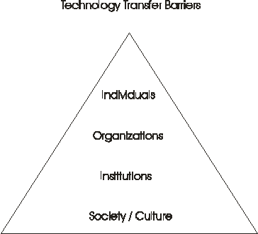
In Malawi, the social and cultural barriers that have been the most difficult to assess and address are those that have to do with the historical lines of decision making. Malawi has historically employed a very centralized and hierarchical decision making process. This has had a dramatic effect on how research is designed and projects implemented. It has not been possible to adequately institutionalize GIS activities in Malawi because of the lack of involvement of those within the highest levels of the government. As a result, the adoption process has been slow, but anticipated. It is a barrier that can be overcome through a more rigorous sensitization campaign and a more thorough understanding of each organization seeking to adopt.
Because of a very rigid and centralized decision making structure in Malawi, the institutional infrastructure has not been developed that could support professional level advancement, let alone a more decentralized decision making structure that would result. Professional levels within the government civil service are not currently established that could coexist alongside a very rigid hierarchical infrastructure. Professionalism is stifled as there is no funding or advancement possible for those developing new technical expertise, responsibilities, and tasks. Thus, current organizational and financial infrastructures in place in the Malawi civil service are also significant barriers. The reality is that Malawi civil servants are immensely overworked and under-compensated at all levels of government service. Currently, a significant number of well qualified and overlooked government officers are fleeing the government for the private sector or oversees.
As an example, many recently returned Ph.D. students with extraordinary technical skills enter the civil service at the lowest possible level which has contributed significantly to a high rate of government employee turnover. This environment is not conducive to individual and organizational needs for adopting new technologies. This lack of professionalism within government service has thus resulted in low morale and a high level of absenteeism.
In Malawi there is also a very unique and noticeable situation in which, at the individual level, there is a lack of skills due to a lack of scientific and research deficiencies that need to be overcome if this technology is to be adopted sustainably. Most of the trainees that have been participating in the Clark Labs training program lack the capacity to initiate, conceptualize, articulate and conduct independent research within their agencies, especially research design related to environmental management. Although most of the trainees have been adept at acquiring the fundamentals of GIS, a much broader range of skills are needed and increased support is essential from host agencies in order for them to effectively employ these new tools.
Given all these impediments to the transfer of technology in Malawi, we developed a very unique implementation strategy. This strategy calls attention to the deficiencies at all levels of the pyramid and move towards the development of a more professional and cooperative environment in which to operate, without which, the sustainable adoption of GIS could not occur.
In order to address the many barriers of the transfer process, Clark Labs developed an alternative strategy for technology transfer. Termed the Ecological Approach, it seeks to develop the capacities at all levels within the pyramid, not just the technical capacities. From this perspective, the process is long-term and seeks self-reliance as the ultimate goal.
The first step in the process was creating greater awareness within the organizations adopting the technology. This included the development of individual capacities within key organizations that could then facilitate the sensitization process. Clark Labs developed an extensive in-service training program in order to train an initial cadre of government officers who could then participate in generating greater awareness for the use of the technology, increase understanding of the barriers involved, and to gain essential long-term support.
During the early stages of the project, training has been the most visible component of the Clark Labs program. Given the paucity of human resources available with knowledge of GIS, the program adopted what we termed the wall-of-lead theory to GIS training in Malawi. It was assumed from the beginning that due to anticipated high turnover rates of qualified trained employees, any long-term initiative would have to rely on a cadre of trained personnel, not one or two star individuals. Over the life of the project, Clark has trained some 70 government officers and university faculty in the use of GIS, Image Processing and GPS technologies. The primary vehicle for this has been four separate cycles of three training courses each: introductory, intermediate and advanced. Topics covered include:
In addition to training sessions, special emphasis was given to the development of agency-specific pilot projects that would strengthen the procedures learned during the trainings. In each case, emphasis was placed on the development of pilot projects that were of specific use to that agency, without necessary reference to the larger needs of the MEMP project. It was assumed that these projects could serve as discussion points within their agencies on the value and future development of GIS. Pilot projects included:
Also, a series of specialty trainings were developed to address specific concerns of the participating government agencies. These included specialty training in map digitizing, soft-copy photogrammetry, ground-truthing procedures, and rapid rural assessments for the collection of non-biophysical data.
The wall-of-lead approach to capacity building in Malawi proved justified. Since it was assumed that the project would lose many individuals through lateral and vertical promotion and disease, training a large group within each agency provided a strong base from which the technology would be resistant to continual disruptions. And despite these challenges, there remains a core of expertise in each of the agencies. In addition, some of the individuals we originally lost to horizontal promotion have since re-entered the group through vertical promotion.
In conjunction with the short-term goals of the in-service training program, Clark Labs also set out to address some of the longer-term sustainability issues. Clark Labs felt strongly about making itself obsolete and as a consequence, a special effort has been made to expand the training program into the University of Malawi (UNIMA) system. This effort has taken two approaches. First, UNIMA lecturers now participate in a training of trainers program which has included the development of lecture materials, presentation aids, tutorial exercises and data sets. These lecturers have already begun teaching portions of the ongoing in-service training program described above. At the same time, it is vital that there is routinely, a continual stream of trained professionals into the government service. As a result, we have also begun a program with UNIMA to advise on curriculum development and training within the university system.
An important factor of a viable GIS implementation strategy is the establishment of a professional society that could help promote professionalism within the ranks. Over the past 18 months, a core of dedicated trainees and analysts have banded together to form the Malawian Society of GIS Professionals. While still in its early stages (a formal constitution and legal status are targeted for later this year), the Society already informally functions, and was instrumental in organizing the logistics for a specialty course in digitizing. Clark Labs acts as advisors to this group -- a body that should have an important role to play in future issues of professional certification as well as providing a venue for cross-sectoral discussion and professional advancement.
Alongside the development of the professional society, efforts are also being made to create regional and continental ties with other African professionals and societies. The AfricaGIS Conference is held every two years throughout Africa and brings together hundreds of professionals on the continent. Also, regional efforts have been made with Southern African organizations who have also been struggling with adopting geographic technologies.
In order to support a cadre of GIS analysts, a mapping infrastructure was also seen as important and the development of a National Mapping Program was conceptualized. What is envisioned is the coordinated development of digital map data from government agencies, or the private sector, that can be used together in cross-sectoral analyses with assurance of interoperability with respect to formats and standards.
Of course, a key element of any national program is the establishment of a set of standards that will ensure comparability and interoperability of digital data sets, particularly map and image data. Clark Labs has worked closely with the Department of Surveys over the past two years to develop a Digital Map Data Standard that covers the key issues of:
The Department of Surveys is currently reviewing a document for adoption as a departmental standard. This is a critical issue for Surveys, since the data they provide are not only a service, but also a statement of data quality, as well as, the level of professionalism
Another key element for a sustainable program is the proper archiving and distribution of data. While it is envisioned that such archives will remain within the organizations that initially develop the data, we also see the need for a centralized facility in which the availability of environmental data can be ascertained. Several alternatives are now being explored by the GOM.
What will ultimately contribute to the failure of any GIS initiative is the lack of understanding of the many barriers to the process. A non-technological approach must be adopted if this understanding is to take shape. It is from this comprehensive awareness that a more favorable organizational structure can be developed to absorb new technologies. And it is within this structure that human resources should be adequately developed and sensitized.
Thus, it is vital that a high level of professionalism be developed for sustainable long-term adoption. Currently in Malawi, there is a change of perception taking place as many of the trainees are now being recognized as more than typical civil servants moving up through the ranks, but as a group of professionals with extensive and unique skills. The Malawi Society of Professionals has done much to foster this image. It is this cadre that will also be instrumental in influencing any change in the GOM civil service structure. In Malawi, we have tried to encourage this professional level capacity within the GOM, a capacity that in the long run will allow organizations to move toward self-reliance. In the end, this project has significantly increased the awareness of the potential for geographic technologies for environmental monitoring in Malawi as well as highlighted its impediments.