
|
|||
|
|
|||
|
|
|||
|
|
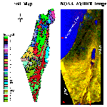
A soil map of Israel after Dan et al., 1977 with a georeferenced NOAA AVHRR satellite image taken during winter. A description list of the soil groups is provided in English and Hebrew. Also available is a conversion table from Dan's to both the USDA and FAO classification systems. The image was kindly provided by the Remote Sensing Laboratory at Bloubsten Institute for Desert Research at Sde-Boker Israel. |
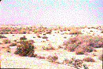 |
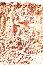
1. View of soil sample coded K-1. The soil location is the Jordan Valley, near Gilgal, Israel (coordination point: 19721577 in Israeli internal system). This soil is named Salorthid according to the USDA system and Solonchaks according to the local Israeli classification system (Dan et al., 1975). Annual precipitation in the area is about 100mm. The soil was developed on the Lisaan Marl, and has not had the salt washed out of it. It consists of very high E.C. values (37.7mmho/cm) and high SAR value (11.8). The CaCO3 content is 42.8% and the texture is sandy-loam (4.1%, 61.1%, and 34.7% of clay, silt, and sand, respectively) with specific surface area (SSA) of 194m2/g. Several dark spots along the surface indicate a relatively high salt concentration. The dark color is due to relatively high hygroscopic moisture along these spots. The soil is not cultivated. |
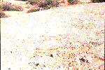 |
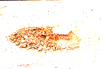
2. Close up overview of the crust developed on sample coded K-1 from slide #1. |
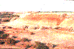 |
3. Sample coded L-1 located north of sample K-1. It is classified as Xerochrepts according to the USDA system and Alluvial-arid-brown-soil according to the local Israeli classification system (Dan et al., 1975). The soil was entered into cultivation after most of the salt was washed from the soil. The agricultural activity is based on dropping-irrigation technique (an irrigation technique developed for an aridic area about 20 years ago). At the soil’s base, drainage pipes were installed to remove saline water from the root zone. In this slide, these buried pipes are exposed to a nearby creek and to the Dead Sea. |
 |
4. View west to the soil in slides #1, 2, and 3. The soils near the road (L-1) are less saline than the soils located to the east (K-1). Fresh water for irrigation is taken from local wells and springs on the east side of the Judaea Mountain Aquifer. |
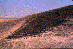 |
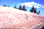
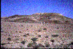
5. Sample O-2 (on the top of the hill) and O-1 (on the slope of the hill) showing a topo-sequence view. Both soils are located on the East edge of the Judaea Desert, Israel (coordination point: 19021575 in Israeli coordination system). This soil is named Torriothents according to the USDA system and Rebdzine-desert Lithosols according to the local Israeli classification system (Dan et al., 1975). Annual precipitation in the area is about 120mm. Both soils were developed on Marl but have a different chemical composition based on the local topography. As O-1 is located on the slope, it is more leached than O-2 (EC of 0.86mmho/cm for O-1 and 15.4mmho/cm for O-2). Also, the chemical composition and SSA of O-1 are different from those for O-2. O-1 is loam soil with 20.7%, 31%, and 48.3%, and O-2 is silty soil with 24.6%, 59.7%, and 15.7% of clay, silt, and sand, respectively. In O-2, the SSA is 107m2/g and in O-1, 176m2/g. The CaCO3 content is 74.2% and 55.9% for the two samples, respectively. The "wave" structure on the slope (O-2) is the result of the strong east-bound runoff stream from Judaea Mountains. |
 |
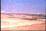
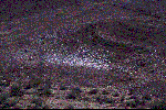
6. A view toward the Jordan valley from soil coded O-2. |
 |
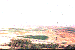
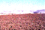
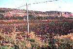
7. Same as slide #6 but with a broader view of the Jordan valley. The settlement appearing in the middle of the image is Gilgal. It was established in 1969 and is located 140m below sea level. Until 1969, the area was bare and saline, but Gilgal farmers, with advanced agro-technical activity, have succeeded in turning the saline, bare soils described in #2, 3 and 4 into relatively fertile agricultural soil (see the green fields). |
 |
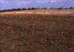
8. View of unvegetated and vegetated soils from the Jordan valley. The soil is classified as Xerochrepts according to the USDA system and Alluvial-arid-brown-soils according to local Israeli classification system (Dan et al, 1975). |
 |
9. Closeup overview on the unvegetated soil from slide #8. Note the cotton debris left on the field from the previous crop season. |
 |
10. Sample code W-1, located in southern Israel near Mishor Yamin (coordination point 15650448 in Israeli coordination system). This soil is named Torriorthents according to the USDA system and Sandy-regosols according to the local Israeli classification system (Dan et al., 1975). Annual precipitation in the area is about 100mm. The soil was developed on eolian sand and consists of a significant crust which was developed by the rain drop energy. The E.C. is 1.47mmho/cm, CaCO3 content is 16.06%, and the texture is sandy loam soil with 72.2%, 15.2%, 12.6% of clay, silt and sand, respectively. The SSA is 81m2/g. |
 |
11. Sample coded H-13 represents heavy soils from the west edge of the Jordan Mountains located near Harbata, Latron, Israel (coordination point 15361410 in Israeli coordination system). This soil is named Xerert according to the USDA system and Brumusols according to the local Israeli classification system (Dan et al., 1975). Annual precipitation is about 600mm. The soil was developed on coarse alluvial material transported from the west Judaea Mountains regime. The E.C. (0.86) is relatively low due to moderate to low agricultural activity and a good natural drainage system. The texture is clayey soil with 46.8%, 12.4%, 40.7% of clay, silt, and sand, respectively. The CaCO3 content is 13.7%, and the SSA is 303m2/g. The main crop is cotton, and some debris can be seen. |
 |
12. Sample coded H-1 represents alluvial soils located west of slide #11 (H-13) and on the west slope of the Judaea mountains. The soil is located near Tel-Nof, Israel (coordination point 135251392 in Israeli coordination system). This soil is named Exerert according to the USDA system and Grumusols according to the local Israeli classification system (Dan et al., 1975). Annual precipitation is about 600mm. The soil was developed on fine alluvial material transported from the Judaea Mountains. The E.C. is 0.73mmho/cm, and the texture is sandy clay soil with 46.8%, 12.4%, 40.7% of clay, silt, and sand, respectively. The CaCO3 content is 8.8.7%, and the SSA is 234m2/g. |
 |
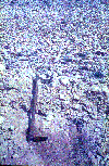
13. Sample coded G-1 represents a soil contaminated with salt from a high ground water table (40-80cm). The soil is located close to the Mediterranean Sea where the west Judaea is exposed (Maagan Micahel) (coordination point 15361410 in Israeli coordination system). This soil is named Xerert according to the USDA system and Grumusol according to the local Israeli classification system (Dan et al., 1975). Annual precipitation in the area is about 600mm. The soil was developed on alluvial material transported from the nearby Carmel Mountains (seen in the background). The light spot in the middle of the image is salt accumulation on the soil surface, which prevents agricultural success. |
 |
14. This aridic soil at Makhtesh Ramon, Israel, is classified as Gypsiorthids according to the USDA system and as Reg soil according to the local Israeli classification system (Dan et al., 1975) (coordination point 15361410 in Israeli coordination system). Annual precipitation is 50mm and the soil is very thin. Notice the salt/gypsum concretion on the soil surface. |
 |
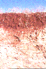
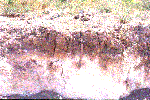
15. A profile view of sample coded H-5 located at Maale Edomim
Israel (coordination point 18221356 in Israeli coordination system).
This soil is named Xerochrepts according to the USDA system and
Dark-brown-soils according to the local Israeli classification system
(Dan et al., 1975). Annual precipitation is about 300mm. The soil
developed on a local spot of alluvial material. Some chemical properties
of the three horizons are: |
 |
16. A profile view of sample coded B-10 developed on chalk near Ben-Shemen, Israel (coordination point 15361410 in Israeli coordination system). This soil is named Haploxerolls according to the USDA system and Brown rendzina according to the local Israeli classification system (Dan et al., 1975). Annual precipitation is about 600mm. the 0-5 cm horizon has the following characteristics: The E.C. is 0.48mmho/cm, the soil texture is clayey soil with 59.5%, 16.6%, and 423.9% of clay, silt and sand, respectively. The CaCO3 is 20.4%, and the SSA is 323.7m2/g. |
 |
17. A profile view of sample coded C-9 developed on chalk, near Beit Shemesh Israel (coordination point 15131281 in the Israeli coordination system). This soil is named Xerorthent according to the USDA system and Pale rendzina according to the local Israeli classification system (Dan et al., 1975). Annual precipitation is about 500mm. The E.C. is 0.52mmho/cm, and the soil texture is sandy clay soil with 45.2.8%, 0%, and 54.8% of clay, silt, and sand, respectively. The CaCO3 content is 51.47%, and the SSA is 233.6m2/g. |
 |
18. An exposure of a leoss soil profile, southern Israel (Netivot). The annual precipitation in the area is about 200mm, and the parent loess material was brought by aeolian activity from southern desert areas. The soil profile shows AC transaction. The soil is classified as Loess in the Dan et al, 1977, classification system and Loess Raw Soil in Rabikovitz 1992 classification system. The equivalent definition of the USDA is Torritfluvent (The slide was taken by Prof. A. Singer, Soil and Water Department Faculty of Agriculture, Hebrew University of Jerusalem). |
 |
19. A typical profile of Hamada Soil (after Rabikovitz 1992) or Reg Soils (after Dan et al. 1977) showing the desert pavement of the soil. The physical reactions are more dominant than the chemical, and the weathered soil is highly correlated with the parent material, which in this location is calcite and dolomite. The area is Hameishar where the annual precipitation stands on 50mm. The soil is classified as Xerrothents base in the USDA classification system, (The slide was taken by Prof. A. Singer, Soil and Water Department Faculty of Agriculture, Hebrew University of Jerusalem. |
 |
20. A Desert pavement of Hamada (after Rabikovitz, 1992) in the Hameishar area (Reg Soils after Dan et al., 1977). Notice the dark shiny color of the surface pavement provided by a coating called desert varnish or desert lacquer. |
 |
21. A landsacpe view of Desert Alluvial Soil (after Rabikovitz 1992) or Coarse Desert Alluvium (after Dan et al., 1977) from southern Israel. The equivalent USDA definition is Torrifluvents and Torripsamments (The slide was taken by Prof. A. Singer, Soil and Water Department Faculty of Agriculture, Hebrew University of Jerusalem). |
 |
22. A profile of a soil developed on recent martin deposits in the Jordan Valley, eastern Israel. The soil is classified as Rendzina Soil of Valleys by Rabikovitz and Calcareous Serozems according to Dan et al., 1986. The soil is reached with calcareous and suffers from saline problem. The equivalent USDA definition is Calciorthids. (The slide was taken by Prof. A. Singer, Soil and Water Department Faculty of Agriculture, Hebrew University of Jerusalem) |
References
Rabikovitz S. 1992 The Soils of Israel: Formation, Nature, and Properties Hakibbuts Hamehuchad Publishing House, Israel. 489p. in Hebrew, with 1:250,000 soil map of Israel in English and Hebrew.
Dan Y. Yaalon D., Koymdjisky H. and Raz Z. The Soils of Israel. Bulletin 168 of The Volcanic Institute of Agricultural Research, Beit Dagan, Israel 28p. in Hebrew, with 1:500,000 soil map of Israel in Hebrew.