
Climate Viticulture Newsletter - 2020 September
< Back to Climate Viticulture Newsletter
Hello, everyone!
This is the 2020 September issue of the Climate Viticulture Newsletter – a quick look at some timely climate topics relevant to winegrape growing in Arizona and New Mexico.
A Recap of August Temperature and Precipitation
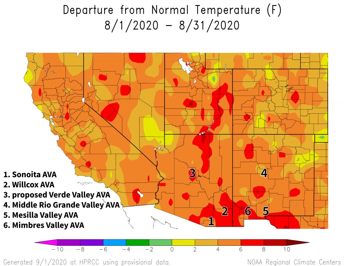
Record heat continued to be front and center last month. Average temperatures for August were 4°F to 8°F warmer than the 1981-2010 normal for almost all of Arizona and much of New Mexico (dark orange and light red areas on map). Temperatures during August last year, which some growers considered hot, were 2°F to 6°F above normal for almost the entire region. Impacts from heat waves such as stalled development, leaf burn and drop, shoot tip burn, and berry sunburn and desiccation may not be due solely to high temperatures, but a combination of them with vine growth stage and vineyard management practices. In established vineyards, tools to help minimize heat damage to vines and fruit include canopy management, irrigation, and cover crops. For new plantings, additionally consider site location, row orientation, heat-tolerant varieties, and drought-tolerant rootstocks.
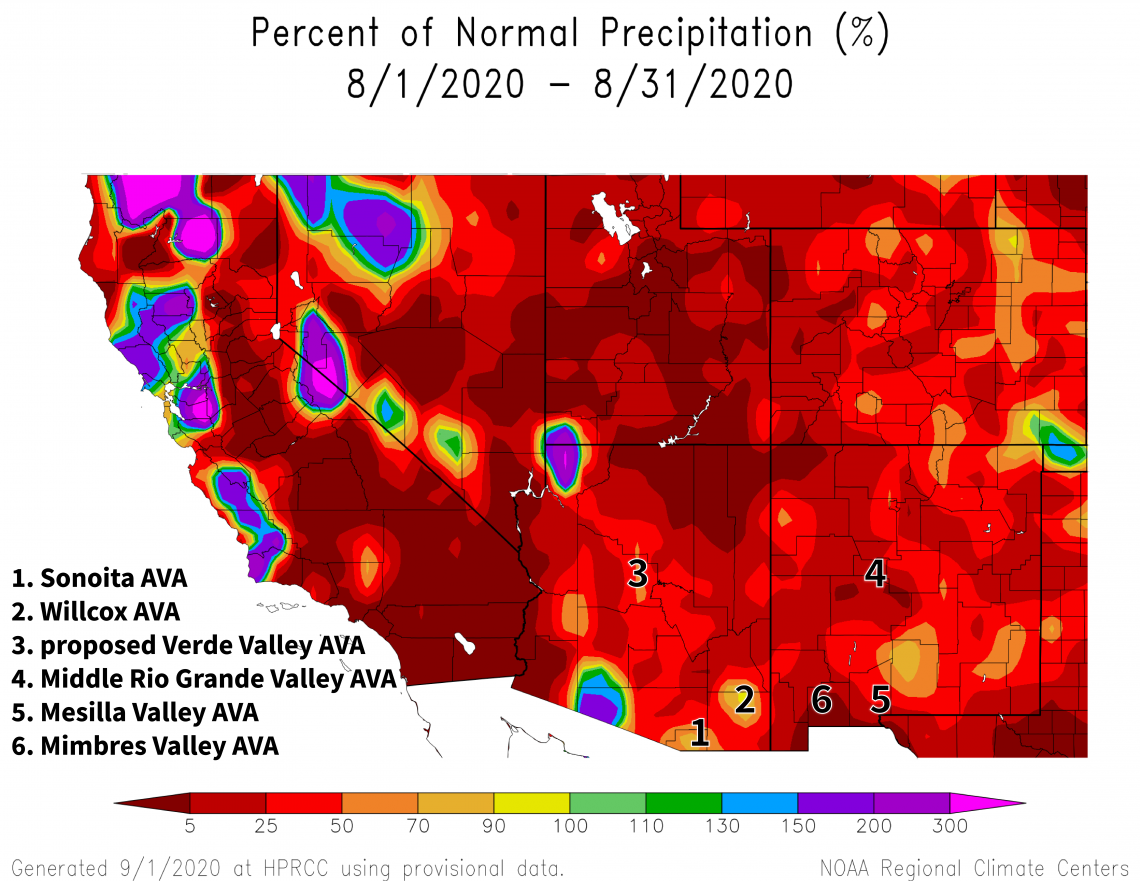
Abnormal conditions like intensified high pressure over the southwestern United States were part of what also led to monthly precipitation totals that were below 50% of normal for almost all of Arizona and New Mexico (red areas on map). Precipitation deficits in August last year were similar for many locations. Even for relatively cooler growing areas in the region not affected by excessive heat, irrigation needs likely were greater under conditions last month. Low soil moisture levels may differentially affect varieties, but when severe, can result in the vine shedding older, basal leaves prior to the more photosynthetically efficient apical ones. This strategy is a plant trait known as hydraulic vulnerability segmentation.
The Outlook for September Temperature and Precipitation
The second half of harvest season and post-harvest management of irrigation and fertilizer are two big backdrops for the coming month, the latter of which is even more critical if heat or water stress limited vine photosynthesis and carbohydrate production in previous weeks.
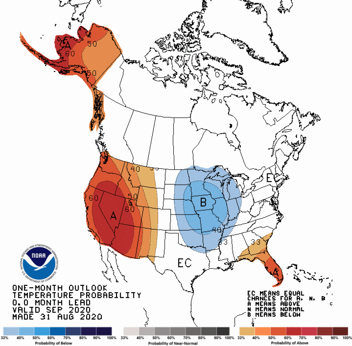
There is a moderate increase in chances for above-average temperatures across all of Arizona (darker orange areas on map). A slight increase in chances for above-average temperatures exists for the western two-thirds of New Mexico (lighter orange areas on map), whereas equal chances for below-, near-, or above-average temperatures cover the eastern third of the state (white area on map). In September 2019, temperatures were within 2°F of normal for southern and western Arizona and 2°F to 6°F above normal for much of the rest of the region.
2020-sep-temp-outlook-noaa-cpc.gif
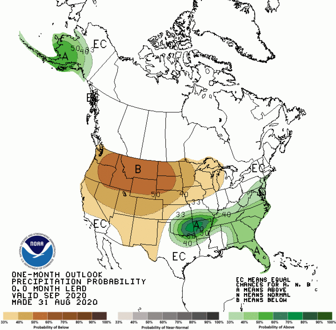
A slight increase in chances for below-normal precipitation exists for the entire region (tan area on map), except for southwestern Arizona where there are equal chances for below-, near-, or above-normal precipitation (white area on map). Monthly precipitation totals in September 2019 were more than 150% of normal across the southern half of Arizona and the ‘bootheel’ area of New Mexico due to moisture from Hurricane Lorena. Most of the rest of the region saw below-average amounts.
2020-sep-prcp-outlook-noaa-cpc.gif
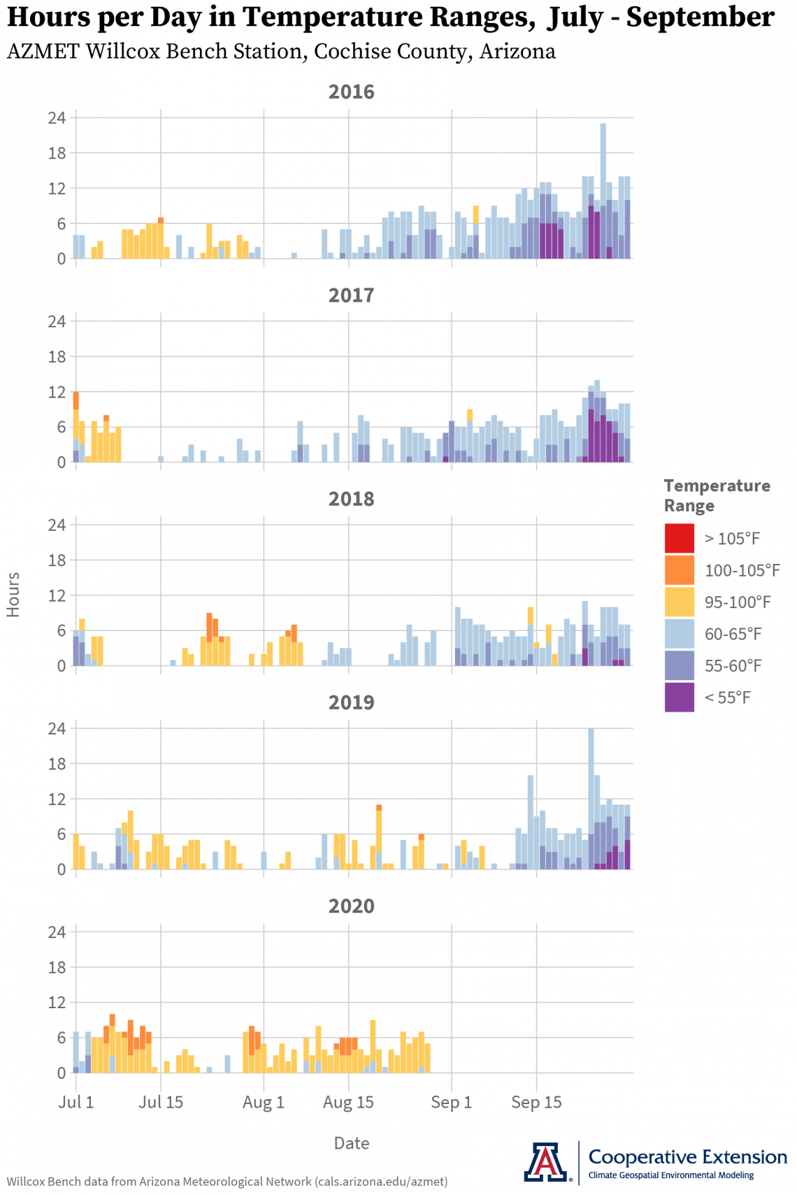
Temperature Ranges and the Ripening Period
As noted last month, high temperatures affect fruit quality through both afternoon maximums and early morning minimums. Recent grower observations from California suggest that warmer-than-average conditions additionally can shorten the time between veraison and harvest, something that could also depend on varieties, soil properties and moisture levels, and management approaches. At the AZMET Willcox Bench station, the number of hours above 95°F (orange and red bars on graph) during the ripening period this year is greater than that of the previous four years. Hours below 65°F (blue and purple bars on graph) are similar to those in 2019, and fewer than those in 2018, 2017, and 2016. Please let us know if you would like us to run this analysis with hourly temperature data from your vineyard.
summer-chill-heat-azmet-willcox-bench-2020-09-01.png
The latest forecast for ENSO (El Niño Southern Oscillation) – parts of the atmosphere and ocean across the tropical Pacific Ocean that cause El Niño and La Niña events – continues to put roughly equal chances on neutral or La Niña conditions happening this fall and winter. These conditions favor near- or below-normal hurricane activity to the west of Mexico and Central America, which may reduce our early-autumn precipitation.
Isaac Mpanga, Area Associate Agent with Cooperative Extension in the Verde Valley, is leading a monthly series of remote meetings for commercial horticulture and small-scale farmers to share science-based information on topics like pests, diseases, marketing, and food safety. The goal is to help improve farm productivity, profitability, sustainability, and food security. Please email yavapaipres@cals.arizona.edu to register. The next meeting is September 14.
Estimates of winegrape water use for southeastern Arizona from AZMET are back in production after a brief hiatus. Please contact us to sign up for a weekly email that forwards this information.
For those of you in southeastern Arizona, Cooperative Extension manages an email listserv in coordination with the Tucson forecast office of the National Weather Service to provide information in the days leading up to agriculturally important events, like record-high temperatures and incoming moisture from tropical cyclones. Please contact us if you'd like to sign up.
Please feel free to give us feedback on this issue of the Climate Viticulture Newsletter, suggestions on what to include more or less often, and ideas for new topics.
Did someone forward you this newsletter? Please contact us to subscribe.
Have a wonderful September!
With support from: