
Establishment
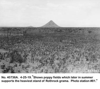
1919 04 25 40736A Poppies & Huerfano Butte.jpg
The Establishment of the Santa Rita Experimental Range (adapted from Medina 1996)
The Santa Rita Experimental Range (SRER) was originally contained within the Santa Rita Forest Reserve, as established by Presidential Executive Order of April 11, 1902, by President Theodore Roosevelt. President Mckinley also signed an Executive Order on October 10, 1900, setting aside sections 26, 27, 34, and 35 in T.14S., R.14E, which were included in the 1902 transfer. During this time, forest reserves were administered by the Department of the Interior. In 1905, the forest reserves were transferred to the Department of Agriculture and consolidated with the Bureau of Forestry to form the Forest Service. In 1901, Dr. David Griffiths of the Bureau of Plant Industry and Dr. R. H. Forbes, and Dr. J. J. Thornber, with the Agriculture Experiment Station at the University of Arizona in Tucson, began making observations and some investigations on SRER and at the Arizona Experiment Station (Griffiths 1904).
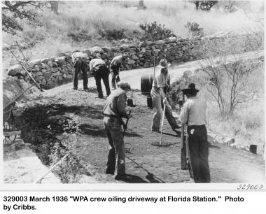
1936 03 xx 329003 Florida roads WPA crew.jpg
On July 1, 1910, Executive Order 1222 transferred lands then known as the Santa Rita Range Reserve to the Bureau of Plant Industry, which was subsequently transferred to the Forest Service, Branch of Research, in 1915. Henceforth, SRER was administered as a Forest Service research area with no national forest system designation, until transfer to the State of Arizona in 1987. That transfer did not include the Florida Station Headquarters.
On July 1, 1910, President Taft set aside 41,911.76 acres, which consisted of most of the present size of SRER. Two other Executive Orders (4261 of July 3, 1925, and 4602 of March 2, 1927) provided for the addition of 12,120 acres. These latter Orders were revoked by Public Land Order No. 1363, November 15, 1956. But, an addition of about 711 acres, formerly described in the Secretary of Agriculture's Regulation "U-4" of January 15, 1941, included the site occupied by the experimental range headquarters, resulting in the present size of 53,159 acres.
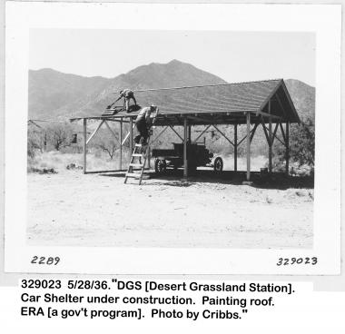
1936 05 28 des grs sta car shelter & car.jpg
References
Gillespie, William B. 2003. Early Years of the Santa Rita Experimental Range and Florida Station. Pima County GIS Library Contents - Metadata
Griffiths, David. 1904. Range investigations in Arizona. Bureau of Plant Industry Bulletin No. 67 (10 plates). Washington, DC: U.S. Department of Agriculture. 62 p.
Medina, Alvin L. 1996. The Santa Rita Experimental Range: History and Annotated Bibliography (1903-1988). General Technical Report RM-GTR-276 Rocky Mountain Forest and Range Experiment Station Forest Service U.S. Department of Agriculture. 67 p.