Examples of Current Research Projects
Between 2013 and 2021, more than 120 research projects have been conducted on the Santa Rita Experimental Range (SRER) by researchers from
the University of Arizona, the Southwest Watershed Research Center of the US Department of Agriculture (ARS-USDA), the National Ecological Observatory Network (NEON), and by other universities, research centers, museums, associations, and US Departments from all over the United States, Canada, and Europe, that visited the SRER to collect data for their projects. Examples of these extended partnerships include the universities of California, Iowa, Michigan, New Mexico, Oklahoma, Utah, and Wyoming, the Audubon Society, the Arizona Game and Fish Department, the Chicago John Murphy Herps Field Museum, the universities of Bristol (United Kingdom), and of Quebec (Canada), and the Max Planck Institute (Germany).
In addition, there are many on-going repeated measurements activities being performed on the SRER by the University of Arizona to maintain the SRER Data Resources (e.g. precipitation data collection, vegetation measurements, repeat photography) or plan cattle grazing (e.g. pre- and post-utilization transects) as well as the regular observations made by the ARS-USDA https://www.tucson.ars.ag.gov/dap/ and by NEON at the NEON SRER field site.
Some examples of the projects conducted on the SRER are provided below.
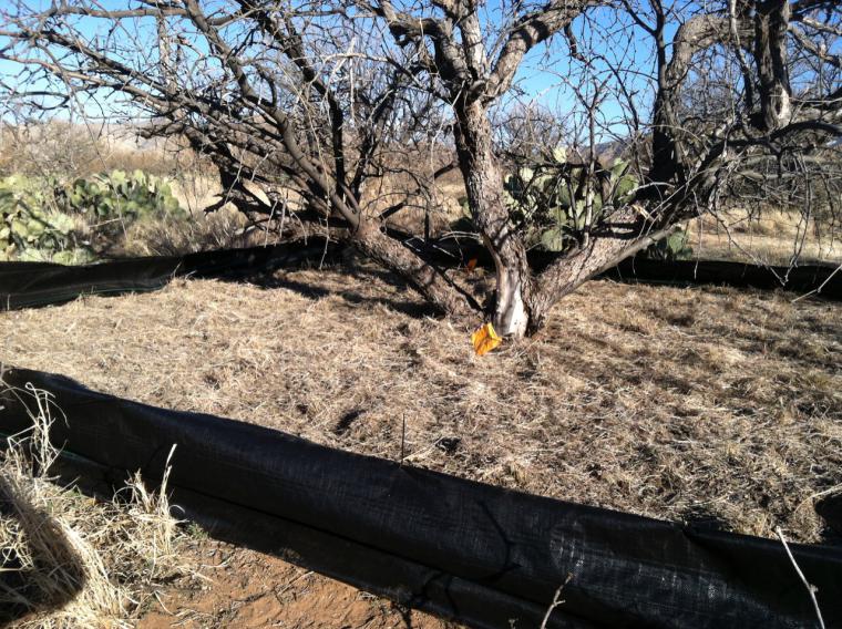
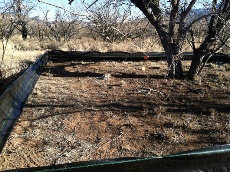
The DIRT (Detrital Input and Removal Treatments) were started in 1956 at the University of Wisconsin Arboretum by soil scientist Dr. Francis Hole. DIRT assesses how the source and rates of litter inputs affect the long-term stability, accumulation, and chemical composition of carbon in soils over decadal time scales. Soil organic carbon is critical to portion of the global carbon cycle, but controls over the soil organic carbon balance remain poorly understood. The DIRT network was established in forested ecosystems, but these questions are also important in shrub-encroached ecosystems. The Santa Rita was the first site of the Dryland DIRT (‘D-DIRT’) sub-network. The D-DIRT sites include litter manipulations in plots with contrasting vegetation cover (grass and shrub canopies).
Link to the DIRT web page: https://dirtnet.wordpress.com/
Data from this research project are available at Additional Research Datasets.
Research_grass_litter_Throop.jpg
Research_grass_nolitter_Throop.jpg
Research_shrub_litter_Throop.jpg
Research_shrub_nolitter_Throop.jpg
Team Members
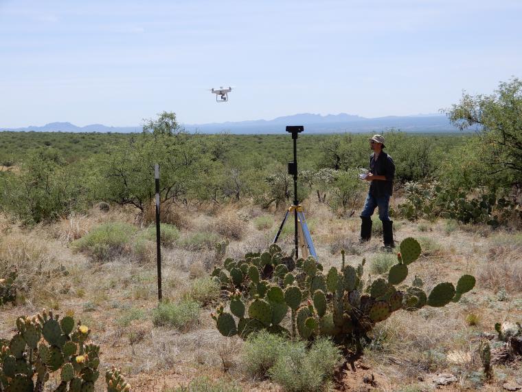
Jeffrey K. Gillan, Guillermo E. Ponce-Campos, Tyson L. Swetnam, Alessandra Gorlier, Philip Heilman, and Mitchel P. McClaran
Research Description
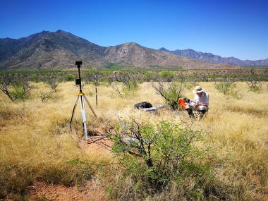
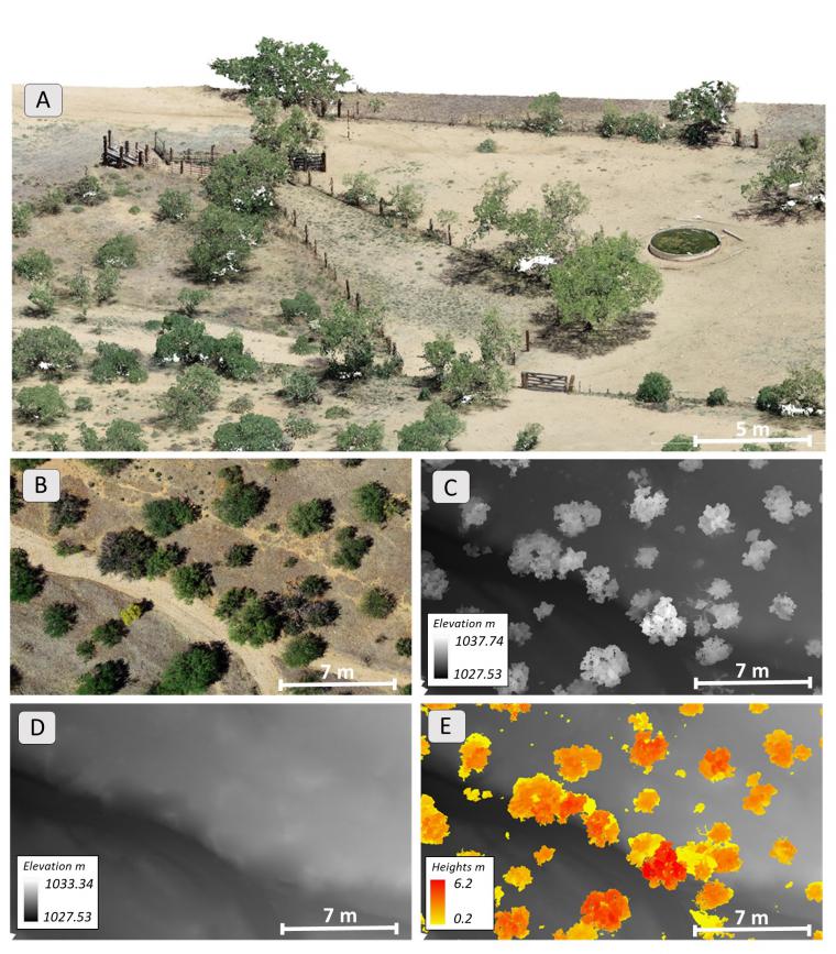
In adaptive management of rangelands, monitoring is the vital link that connects management actions with on-the-ground changes. Traditional field monitoring methods can provide detailed information for assessing the health of rangelands, but cost often limits monitoring locations to a few key areas or random plots. Remotely sensed imagery, and drone-based imagery in particular, can observe larger areas than field methods while retaining high enough spatial resolution to estimate many rangeland indicators of interest. However, the geographic extent of drone imagery products is often limited to a few hectares (for resolution ≤1 cm) due to image collection and processing constraints. Overcoming these limitations would allow for more extensive observations and more frequent monitoring. We developed a workflow to increase the extent and speed of acquiring, processing, and analyzing drone imagery for repeated monitoring of two common indicators of interest to rangeland managers: vegetation cover and vegetation heights. By incorporating a suite of existing technologies in drones (real-time kinematic GPS), data processing (automation with Python scripts, high-performance computing), and cloud-based analysis (Google Earth Engine), we greatly increased the efficiency of collecting, analyzing, and interpreting high volumes of drone imagery for rangeland monitoring. End-to-end, our workflow took 30 d, while a workflow without these innovations was estimated to require 141 d to complete. The technology around drones and image analysis is rapidly advancing which is making high-volume workflows easier to implement. Larger quantities of monitoring data will significantly improve our understanding of the impact management actions have on land processes and ecosystem traits.
References and Supplementary Material
Gillan, Jeffrey K.; Ponce-Campos, Guillermo E.; Swetnam, Tyson L.; Gorlier, Alessandra; Heilman Philip; McClaran, Mitchel P. 2021. Innovations to expand drone data collection and analysis for rangeland monitoring. Ecosphere 12(7):e03649. 10.1002/ ecs2.3649 https://esajournals.onlinelibrary.wiley.com/doi/full/10.1002/ecs2.3649
Data, including raw imagery, point clouds (.laz & Entwine Point Tiles), digital surface models, digital terrain models, VHMs, and orthomosaics, and software code are available in CyVerse Data Commons: https://doi.org/10.25739/1w46-n223
Jeffrey Gillan is archiving all of his drone imagery at GeoNadir.com: https://data.geonadir.com/social-profile/55
Research_Drone_Gillan.JPG
Research_Fig3_image_products_Gillan.jpg
Research_Drone_Image_JeffGillan_Rutherford.JPG
The proliferation of unpalatable woody weeds threatens the nation’s rangelands and their numerous services. Several management techniques have long been used to curtail shrub proliferation but are largely reactive and focused on areas where encroachment has progressed to advanced stages. There has been little investment in development of proactive prevention strategies during the early life cycle of invading shrubs that could arguably be more effective both ecologically and economically.
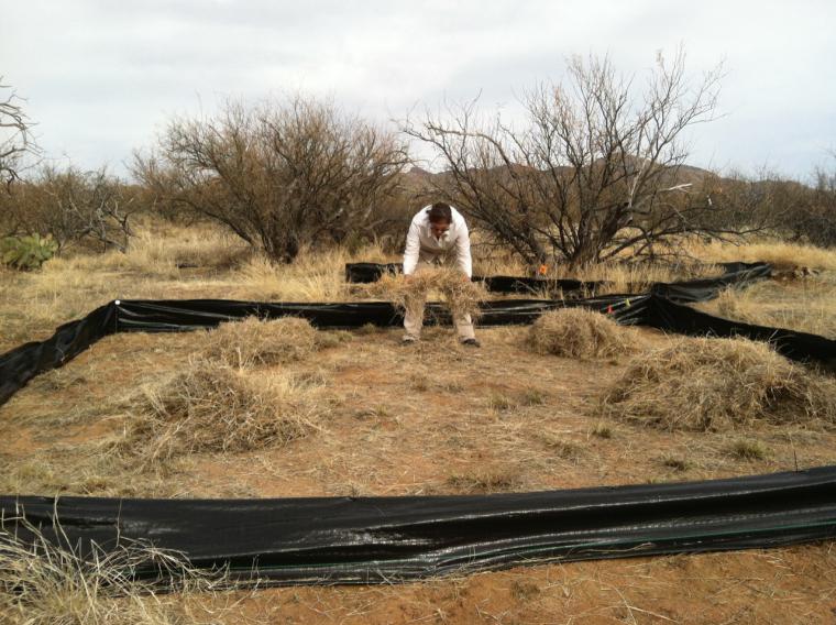
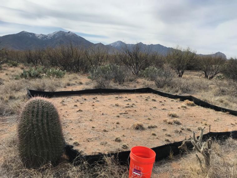
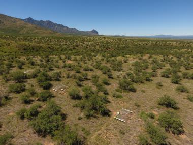
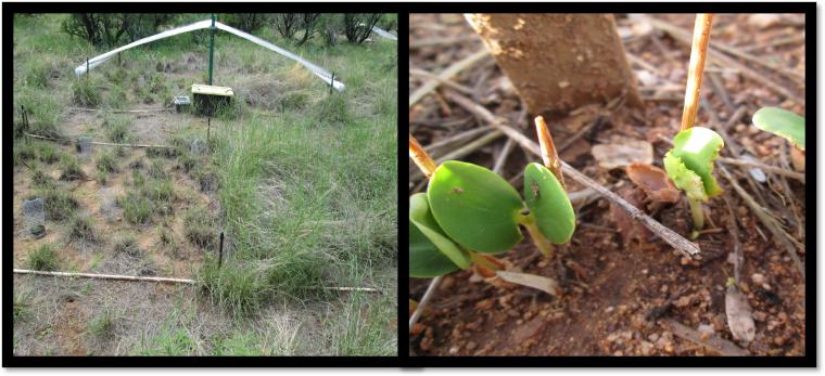
This research project focuses on the critical shrub establishment phase of velvet mesquite (Prosopis velutina) to ask, “How does herbivory by livestock, ants, and/or small mammals interact with precipitation to influence the probability of shrub seedling establishment in grasslands?” This question was addressed by University of Arizona graduate student Austin Rutherford and Professor Steve Archer with Arizona State University collaborators. Using a large-scale experiment from 2017 to 2019, precipitation was manipulated to simulate drought and wet years alongside ambient conditions. Each precipitation treatment was accompanied by additional manipulations to assess the interactive effects of livestock herbivory via simulated heavy grazing/grass defoliation and preferential exclusion of ants and/or small mammals. Shrub seedling recruitment was consistently higher in wet and ambient conditions compared to drought, with the highest in 2017. These interannual differences occurred despite all years having comparable rain days and total monsoon season rainfall amounts. However, the maximum number of consecutive rain days in 2017 (16 days) allowed for additional soil moisture accumulation compared to that in 2018 (8 days) and 2019 (4 days). Recruitment was reduced in areas accessible to small mammals/ants in every year. Contrary to expectations, grass defoliation had no effect in any year. This work suggests shrub recruitment in Sonoran grasslands is highly sensitive to intra-seasonal rainfall patterns, only modestly sensitive to small mammal/ant herbivory, and insensitive to herbaceous cover.
This project aims to help fill knowledge gaps in integrated weed management and state and transition models. Information from the study, coupled with a synthesis of literature on shrub proliferation in grasslands, is being used to develop an online toolkit and web application to (a) alert managers to critical times and locations for inventory and monitoring for shrub invasion, (b) identify windows of opportunity for early intervention, and (c) assist in prioritization of mitigation efforts.
References and Supplementary Material
Rutherford, William A.; Archer, Steven R. 2022. Trait responses of a grassland shrub invader to altered moisture regimes. Plant Soil. https://doi.org/10.1007/s11104-022-05678-w
Rutherford, William A.; Archer, Steven R.; Sala Osvaldo E. 2022. Is shrub recruitment in semi-arid grasslands episodic? (In Prep, Ecology).
Rutherford, William A.; Archer, Steven R.; van Leeuwen, Willem J.D. 2022. Proactive management of woody plant proliferation: a modeling and decision support framework. (In Prep, Ecological Applications).
CCAST StoryMap/overview of the research project
Data from this research project are available at Additional Research Datasets.
Research_ARMS_Seedling_Combo_Rutherford.jpg
Overview
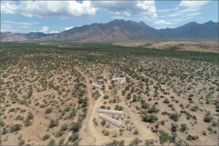
RainManSR is a collaborative field experimental research site investigating the effects of altered rainfall amounts and timing on the structure and function of Sonoran desert rangelands.
Experimental Design
The facility consists of 60 1.3 by 1.6 m plots distributed across five rainout shelters ('houses') which exclude 100% of natural rainfall. Rainfall is harvested onsite and applied manually to simulate various climate scenarios. Plots were trenched down to 1 m depth and isolated from surrounding soil. The existing ecosystem was left intact and consists of mixed annual and perennial grasses and forbs. Each plot was planted with 36 greenhouse-grown seedlings of Digitaria californica (Arizona cottontop) in October 2019.
The first experiment, begun in July 2020, examines impacts of temporal repackaging of a fixed amount of growing-season precipitation, from frequent, small events with shallow soil moisture infiltration to few, large events with deeper soil moisture infiltration but longer intervening dry periods. The second experiment, begun November 1, 2021, adds the element of winter drought (rainfall amount reduction), a common phenomenon regionally.
Timeline
Facility Construction
- October 2018 - February 2019: site soil and plant surveys
- 2019: Roads, fences, and culverts installed, plots trenched and instrumented, shelter frames built
- November 1, 2019: Arizona Cottontop bunchgrass transplants into all plots, well-watered through April 2020
- May 2020: Shelter roofs installed
Experiment 1: Temporal Repackaging of Summer Precipitation
- 2020 & 2021: temporal repackaging of Summer Precipitation from many/small to few/large (4 levels). Winter precipitation following historical average.
Experiment 2: Temporal Repackaging of Summer Precipitation Crossed with Winter Drought.
- 2022 & 2023: temporal repacking of Summer Precipitation crossed with 3 levels of winter precipitation amount (5th, 50th, 95th percentile).
References and Supplementary Material
Zhang, Fangyue; Biederman, Joel A.; Dannenberg, Matthew P.; Yan, Dong; Reed, Sasha C.; Smith, William K. 2021. Five Decades of Observed Daily Precipitation Reveal Longer and More Variable Drought Events Across Much of the Western United States. Geophysical Research Letters 48, 7, e2020GL092293. https://doi.org/10.1029/2020GL092293
Zhang, Fangyue; Biederman, Joel A.; Pierce, Nathan A., Potts, Daniel L.; Devine, Charles John, Hao, Yanbin; Smith, William K. 2022. Precipitation temporal repackaging into fewer, larger storms delayed seasonal timing of peak photosynthesis in a semi-arid grassland. Functional Ecology 36, 3: 646-658. https://doi.org/10.1111/1365-2435.13980
Research_RainMan_SiteView_Biederman.jpg
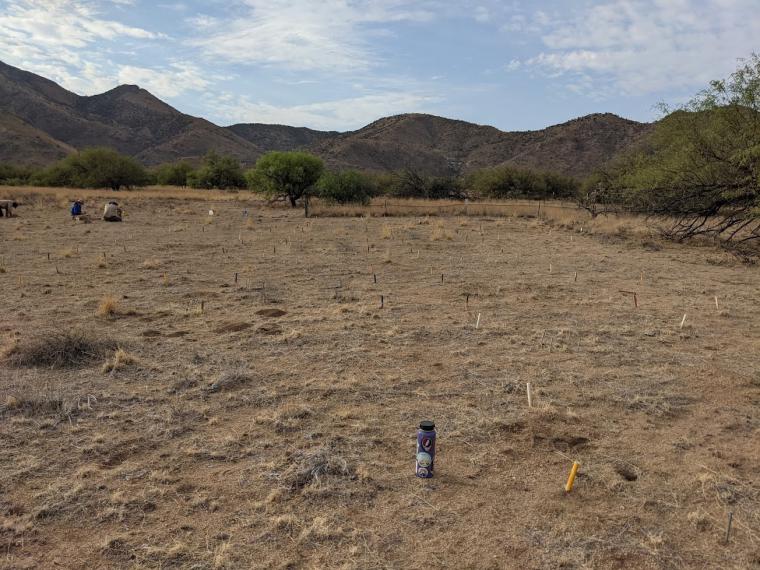
RestoreNet is a highly collaborative restoration field-trial network that provides testing and demonstration of ecological restoration strategies. RestoreNet is managed by the U.S. Geological Survey's Restoration Assessment and Monitoring Program for the Southwest (RAMPS). The network spans private and public lands across 7 major dryland ecoregions in the southwestern U.S. Testing the same restoration techniques across a range of environmental conditions is valuable for building guidance to improve restoration and seeding success across different landscapes. The goal is to provide landowners and resource managers in dryland regions with effective practices to improve the condition of their land. RestoreNet started in 2018 and has grown to currently include 25 sites throughout the southwestern US (AZ, NM, CO, UT, CA). At each site, we test how well seeding with different seed mixes in combination with mulch, soil pits, and ConMod nurse plant structures resulted in successful plant emergence and growth through time. At the RestoreNet site at the Santa Rita Experimental Range (SRER) we are finding that precipitation during the season the site was seeded is highly influential in determining seedling success at restoration sites. The SRER site was seeded during a particularly dry monsoon season (summer 2019), and even with the help of knocking back Lehmann Lovegrass, many species did not germinate or survive after seeding. At SRER, none of the treatments were particularly successful at increasing seeding success, since overall establishment was so low. Across RestoreNet sites, pits and mulch were the most successful for enhancing seedling establishment, and SRER seems to follow the same trends with it’s handful of seedlings.
Research_RestoreNet site2021_Gornish.jpg
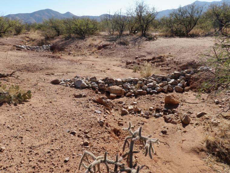
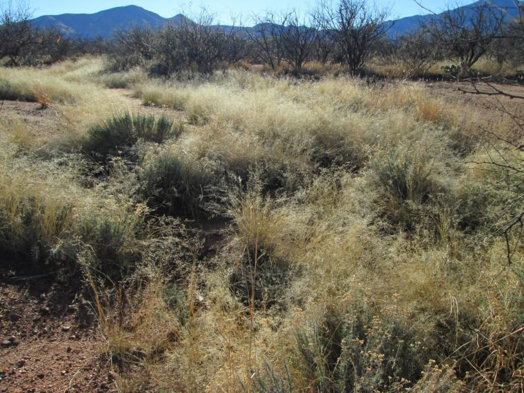
In 2008, two small (4.0 and 3.1 ha) instrumented watersheds located 300 m apart on an alluvial fan on the Santa Rita Experimental Range in southern Arizona were treated with 37 porous, loose rock check dams. The check dams were constructed with the help of student members of Tierra Seca, the University of Arizona chapter of the Society for Range Management.
Rainfall, runoff, and sediment have been measured on the treated watersheds since 1975 when they were instrumented by the USDA-Agricultural Research Service. Thus, excellent baseline data are available to interpret the impacts of the check dams on runoff and sediment.
Both watersheds experienced a change in runoff after check dam construction. However, the change was short-lived on one watershed and is persistent on the other watershed. In addition, the check dams are effective for stabilizing and controlling channel grade but have lesser impacts watershed outlet sediment concentration. This research documents variable response to check dams depending on site-specific characteristics of watershed soils, vegetative cover, and drainage network development.
Overall, with monitoring and maintenance, check dams can be an effective tool for grade stabilization, but watershed restoration requires coupling with additional practices to address degraded interfluve areas.
Sequential photos, scientific publications, and additional information can be found at:
Rangeland Restoration Research (arcgis.com)
Research_SRER_2009_Nichols.jpg
Research_SRER_2020_Nichols.jpg
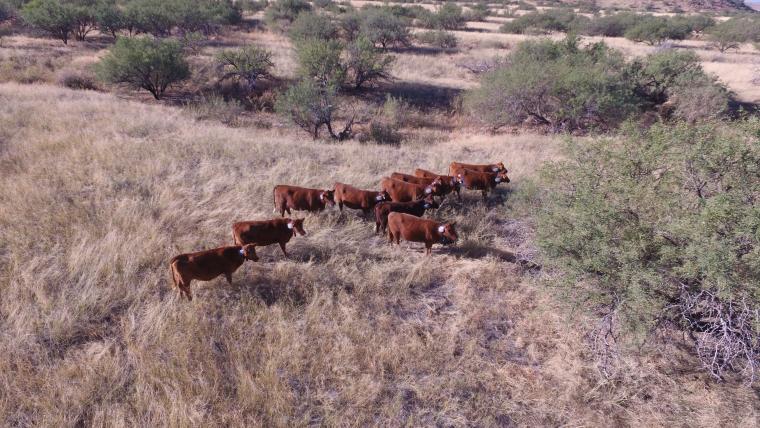
The Santa Rita Experimental Range (SRER) was founded in 1902 and serves as North America’s oldest experimental rangeland. Designated by President Theodore Roosevelt to examine ecological interactions and economics of livestock grazing and rangeland recovery, the SRER has since transformed into a broadscale open-air laboratory for semi-arid ecosystems. Today the SRER hosts an array of research initiatives from the soil to the atmosphere and all points in between. This multifaceted research approach, combined with technological innovation, has allowed for a continuous reexamination of livestock grazing principles on the SRER; all with the aim of maximizing beneficial outcomes for producers and the environment. To further these initiatives, we intend to deploy a virtual livestock fence network [Vence (Vence Corporation of San Diego, California, USA)] across the SRER in partnership with our collaborators at the Santa Rita Ranch (SRR).
This project aims to utilize the functions of Vence technology to explore multiple components of livestock grazing at a scale not previously attainable. The Vence system works by establishing a network of cattle collars (Riders) across each herd on the SRER. These collars are GPS enabled and communicate both via cellular network and satellite. Collars transmit spatiotemporal and biometric data associated with each individual or livestock herd in aggregate. Each collar is programmed remotely using the Herd Manager web-based application (app). Herd Manager enables the establishment of pasture boundaries, inclusion and exclusion zones as well as routine checks on animal location and wellbeing. In addition, collars can be used to manage individual and herd movements, facilitating cattle rotation from one pasture to the next. Collars rely on both an auditory and mild electric stimulus to direct herd movements and encourage livestock to avoid user specified areas such as roads and riparian zones. Communication between the collars and Herd Manager is enabled by multiple relay stations (Gateways) that facilitate data exchange via low-energy LoRa (long range) radio communication. All collar data is stored in the Cloud and typically formatted for use on within Herd Manager only. However, Vence Corp. has agreed to provide the University of Arizona with additional metadata in CSV format. This additional data includes both high resolution spatial and basic biometric outputs that can be used to develop fine scale metrics of grazing efficacy and ecological interaction.
This initiative will focus on three primary components related to the application of Vence technology in real world settings commonly experienced by livestock producers in the Southwest.
- Primary consideration will be given to general use, applicability, and effectiveness as a livestock management tool. All information regarding the use of the Vence technology will be disseminated through Arizona Cooperative Extension via meetings, bulletins, digital media, and related outputs. This technology has the potential to benefit many within the livestock industry and it is, in part, up to the University of Arizona to examine all functions of this technology as a management tool before advocating its use on a commercial scale.
- A general economic assessment will be conducted to examine the Vence technologies impact related to producer capital investment and returns (ROI).
- The metadata associated with this project will be parsed and utilized in a variety of hypothesis driven inquiries potentially including, but not limited to, a) use of targeted grazing in invasive species management, b) use of targeted grazing in fuel load/ biomass reduction, c) livestock resource and/or step selection functions, d) resource selection and animal behavior between drought and normal range conditions, e) animal behavior related to breeding, f) nursing and g) calving.
The impetus for agriculture producers to meet the needs of a burgeoning human population under dynamic climatic conditions has led to an increased global focus on adaptive grazing management and precision agricultural techniques. This research initiative aims to provide practical tools and novel methodologies that livestock producers can utilize to increase herd efficiency and better understand the ecological interactions and impacts of their livestock on a pasture-by-pasture level. If successful, virtual fence technology has the capacity and capability to revolutionize the way livestock is managed across the American West.
For further information, please, contact Andrew Antaya (aantaya@arizona.edu) and Brandon Mayer (buttterzs@arizona.edu). Principal Investigator: George Ruyle.
Research_Vence collared cows from drone.JPG