Description of Repeat Photography Archive
PS333.2-SEP19042.gif

The Santa Rita Experimental Range (SRER) database includes an archive of photographs taken repeatedly over the years from 124 sites throughout the range. The database also includes, for each picture, a text written by the photographers that describes the vegetation and other attributes of the scene, and for each Photo Station location, the UTM coordinates. Access to photographs and texts for a Photo Station location can be made by selecting the Photo Station number from a list or from a hyperlinked map of Photo Station locations on the SRER (Find Photos on a Map).
Mitchel McClaran recorded the UTM coordinates of Photo Stations with a Global Positioning receiver between 1998 and 2000. The coordinates are projected in the NAD83 datum using the GRS1980 spheroid. The images can be downloaded as tagged image format files (*.tif), as joint photographic experts group (*.jpg), or copied as images in the graphical interchange file format (*.gif).
PS333_2_2018_10_thb.jpg
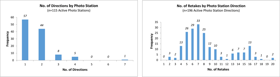
The images are accompanied by a Photo Archive number that identifies the location, direction, year, and month of the photograph. For example, the Photo Archive number 45.1.1948.06 identifies the image as being made at photo station 45 (or PS 45), looking in the direction that is closest to north and on the east side of north, in the year 1948, and the sixth month or June. The direction code ranges from 1 to 7: about half of the locations have photographs taken in only one direction, and about 40 percent have two directions. One location (PS 42) has seven directions that are arranged to provide a nearly 360-degree view. When more than one direction is included for a photo station, the value of 1 was assigned to the direction closest to north on the east side of north, and subsequent values increased in a clockwise direction.
The Retake History of the Photo Stations is summarized in the file below under “Photo Station Retake History Data and Figures". The file includes figures summarizing the Number of Photos taken per Year, the Number of Directions by Photo Station, and the Number of Retakes by Photo Station Direction. The figures are provided for preview below.
The earliest photographs were taken by David Griffiths (1904) between 1902 and 1905 at 16 different locations (PS 219, 220, 221, 222, 224, 228, 229, 230, 231, 233, 234, 251, 332, 333, 334, and 335). The average interval between photographs is approximately 15-20 years, but some locations have repeat photographs made twice a year for a period of up to eight years. Most Photo Stations have photos taken from one or two directions, but Site 042 has the most complete set of photos taken from 7 different directions.
References
McClaran, Mitchel P.; Angell, Deborah L.; Wissler, Craig. 2002. Santa Rita Experimental Range digital database: user’s guide. Gen. Tech. Rep. RMRS-GTR-100. Ogden, UT: U.S. Department of Agriculture, Forest Service, Rocky Mountain Research Station. 13 p.